
soil nitrogen
Type of resources
Available actions
Topics
Keywords
Contact for the resource
Provided by
Years
Formats
Representation types
-
GLORIA Master Site.The 3497m-peak Mount Schrankogel belongs to the highest mountains of the Austrian Alps. Its northern and eastern side is surrounded by glaciers and glacier forelands. Its southern to western faces, however, are not interrupted by glacier Established in 1994 as the first comprehensive alpine to nival long-term monitoring site for high-altitude vegetation in the Alps, with ca. 1000 permanent plots of 1x1m arranged in transects of 30x3m or smaller ranging from 2900m to 3450m. Main purpose is ecological climate impact research. In 2001 it became a master site of the GLORIA network: e.g. method development and testing for species recording in 1x1m plots for GLORIA was partly conducted on Schrankogel. The first major resurvey of plots was made in 2004, the second resurvey was conducted in 2014. Besides long-term monitoring, several other research approaches were/are carried out at the Schrankogel site, such as species and vegetation modeling, vegetation mapping, phenological studies of alpine and nival plants, exclosure studies for grazing impacts at the lower altitudes of the site, soil studies, snow pattern studies (two permanent snow cameras), surface and soil-temperature measurements. In 2014, the the scope was extended to other organism groups such as soil microbiota, soil mesofauna (Oribatida and Collembola in particular), and surface-dwelling arthropods. Site setup, resurveys, or other activities were/are supported by: the Austrian Academy of Sciences through a national grant of the International Geosphere–Biosphere and the UNESCO MaB Programmes, by the Austrian and through the Institute of Mountain Research (IGF) of the Academy; by the Austrian Federal Ministry of Science and Research; the Austrian Federal Ministry of Agriculture, Forestry, Environment and Water Management; the Swiss MAVA Foundation; the Government of Tyrol; the project ALARM (Assessing Large-Scale Risks for Biodiversity with Tested Methods; No. GOCE-CT-2003-506675) in the FP-6 of the EU; the Austrian Climate Research Programme (ACRP: GZ B368633 ACRP6 - SCHRANKOGEL_20YEARS - KR13AC6K11076). For further details on Schrankogel_GLORIA see: http://www.gloria.ac.at/?a=42&b=56
-
The Experimental Farm Groß Enzersdorf is a research and teaching facility of BOKU University of Natural Resources and Life Sciences, Vienna. It was founded in 1902 as a donation to the university by the Austrian emperor; it is a typical arable farm of 140 ha arable fields in Gross-Enzersdorf, Lower Austria. The farm is run in conventional agriculture, but 26 ha are converted to organic farming since more than 20 years. Another 35 ha acreage in Tulln, Lower Austria, plus 6 ha of experimental garden in the city of Vienna, 21. district, are additionally managed by the farm and available for experiments with arable crops, vegetables and fruit species. The experiments include two long-term field experiments that are descibed individually as related plots. These experiments are focussed on long term effects (i) of crop rotation and fertlization since 1906, and (ii) of soil tillage treatments since 1996. The whole farm beyond can be used for any kind of soil, plant or atmosphere observations in experimental settings, representing a typical Pannonian agricultural environment. It is equipped with complete sets of agricultural machinery for large scale farming operation as well as for small experimental plots. On the farm there is also a weather observation station installed by the Austrian Zentralanstalt für Meteorologie und Geodynamik (ZAMG).
-
Plynlimon is at the headwaters of the Rivers Severn and Wye. The infrastructure at Plynlimon consists of 10 instrumented research catchments representing different land use options on the same geological parent material. It is the UK’s Critical Zone Observatory, part of the EU and global network of CZOs and is an ExpeER site. The infrastructure records high temporal resolution river flow and meteorological data (40 year data record) and stream water and precipitation chemistry for cations, anions, trace metals, nutrients, pH and alkalinity (30 year data record) and some data for suspended sediment. The site has an extensive spatial data library including topography, digital terrain model (DTM), soils, geology and vegetation/land-use available, open access, through the Environmental Information Data Centre (https://catalogue.ceh.ac.uk/documents/91961a0f-3158-4d00-984d-91eb1e03e8bd). Sub sites in the catchments represent a range of upland management types: mature/clear cut/replanted conifer forest; acid grassland; eroding peatland; improved grassland.Samples analysed for a wide range of major, minor and trace components. Bulk precipitation and cloudwater chemistry is also measured at one location.
-
The "Istituto Scientifico Angelo Mosso" research site is located on the watershed between Piedmont and Valle d'Aosta (NW-Italy), in the Municipality of Alagna Valsesia (Monte Rosa massif). The Scientific Laboratories of the "Angelo Mosso Institute" at Col d’Olen (2901 m a.s.l.), the heart of this research site, were built between 1905 and 1907, when it became clear that the Capanna Regina Margherita on Monte Rosa (4554 m a.s.l.), as a high-elevation research centre, had become insufficient to the increasing number of requests for use by the international scientific community. From here the idea promoted by Angelo Mosso (1846-1910), professor of human physiology at the University of Turin, to add an additional structure to the Observatory of the Capanna Regina Margherita for make larger laboratories available to researchers and allow study stays at high elevation. This project soon became a reality thanks to the intervention of Queen Regina Margherita, Ministries of Education and Agriculture, the Italian Alpine Club and various personalities of the time. The research conducted at the Institute did not concern only human physiology, but also other disciplines, including alpine meteorology and glaciology, thanks also to the presence of the Meteorological Observatory that flanked the Institute, directed in the years 1925-40 by Umberto Monterin. It is now home to an automatic snow and weather station, managed by the Alpine Troops-Meteomont service. In addition to the University of Turin, the research groups that operate at the site and contribute to data collection and implementation are currently CNR-IRSA, Alpine Troops Command-Service Meteomont, Monterosa 2000 SpA and Monterosa SpA (Monterosa Ski), Protected areas of Valsesia, ARPA Piemonte, ARPA Valle d'Aosta and Sesia Val Grande Geopark. In addition to the valuable historical series of climate data, a series of research activities are devoted to the study of snow-soil-vegetation interactions, with particular reference to carbon dynamics e soil nitrogen (Magnani et al. 2017a,b; Freppaz et al. 2019). In addition, investigations are performed focusing on the chemical characteristics of high-elevation surface waters, fed by different cryospheric features such as rock glaciers, glaciers, and permafrost (Colombo et al. 2018a,b; 2019a,b; 2020; Vione et al., 2021). New research lines, aimed at investigating the most recent environmental challenges, have been added to the previous ones. For instance, investigations on sources and routes of atmospheric carbon and nitrogen species are ongoing. References: Colombo N. et al. (2018a), https://doi.org/10.1002/esp.4257. Colombo N. et al. (2018b), https://doi.org/10.1016/j.scitotenv.2018.05.098. Colombo N. et al. (2019a), https://doi.org/10.1016/j.scitotenv.2019.06.233. Colombo N. et al. (2019b), https://doi.org/10.1007/s00027-019-0670-z. Colombo N. et al. (2020), https://doi.org/10.1016/j.catena.2020.104700. Freppaz M. et al. (2019), https://doi.org/10.3897/natureconservation.34.30737. Magnani A. et al. (2017a), https://doi.org/10.1657/AAAR0016-037. Magnani A. et al. (2017b), https://doi.org/10.1016/j.catena.2017.03.007. Vione D. et al. (2021), https://doi.org/10.1016/j.scitotenv.2020.143464.
-
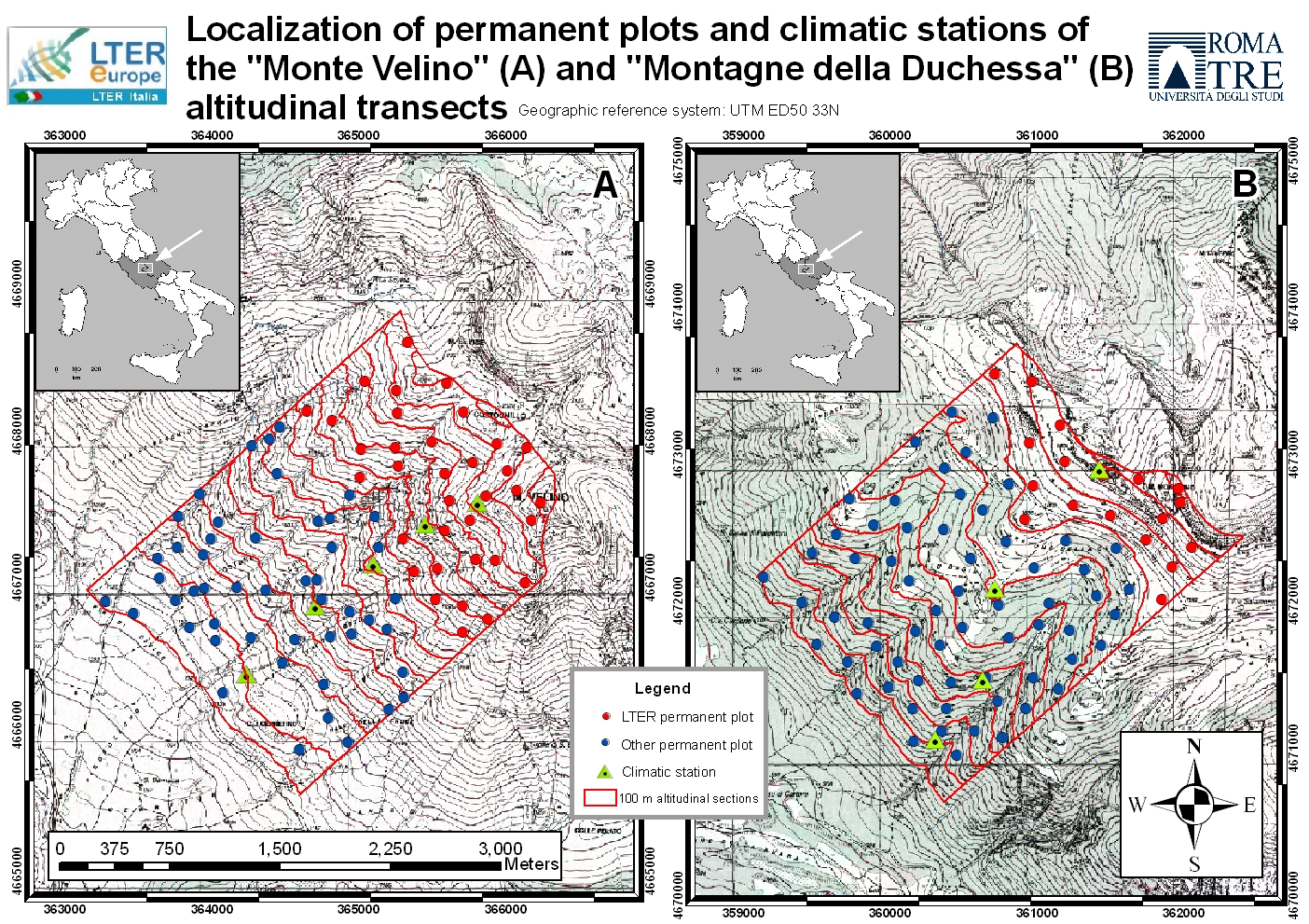
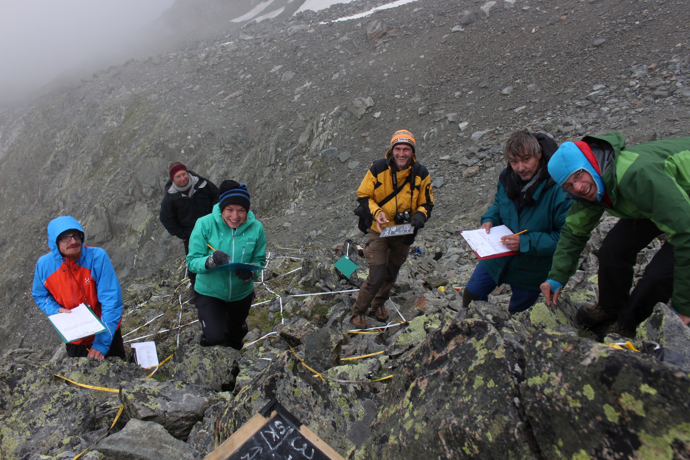
The site includes a large mountainous area in the Central Apennines, almost in the centre of the Italian peninsula and about 70 km west of Rome. It represents an “orographic island” in the Central Mediterranean basin, along the Apennines mountain range. Since 1993, the vegetation has been surveyed at six permanent high elevation plots (Mount Sevice research station, Mount Velino, 2125-2225 m a.s.l.) and (since 2005) at an additional 55 plots along two elevation transects (SW slope of Mount Velino and Mount Morrone), including primary and secondary grasslands, beech forests and alpine tundra. Since 2014, micro-climate data (GLORIA method) have been continuously recorded at the high elevation plots. Vegetation is surveyed yearly in the 6 high elevation plots (each 100 m2 in size) grouped in two cluster-plots (each of 3 plots). Structure and composition changes are studied in two ecologically opposite primary plant communities, both above the timberline: snow-bed grassland and alpine tundra, both characterized by extreme below zero temperatures all year round and frozen soil for 8 months per year, but with very different snow cover duration. Based on the first 30 years of observation, a clear trend toward a decrease of snow dependant species and a parallel increase in drought- and stress-tolerant species has been recognized, linked to a general process of climate change, more accelerated in Southern Europe.
-
This site is located on the territory of National Park “Rila”, Bulgaria. Parangalitsa has been a reserve since 1933. It is situated on part of the southwestern slopes of Rila mountain, covering 1,509 hectares. It contains some of the oldest pine tree forests in Europe with an average age of over 200 years. The site is a part of the network of bioecological stations of Forest Research Institute – BAS and research is focused on highly productive coniferous forests with unique biomass. In the main experimental plots, long-term complex studies were conducted during the period 1979 - 1998, a large-scale database was created and a number of significant scientific results were obtained. In the period 2000 - 2018, separate targeted studies were carried out - focused on some ecosystem processes, which allows the analysis and evaluation of the functioning of ecosystems to be don
-
Coniferous forests and mire.
-
The site consists of high elevation vegetation in central Mediterranean basin, along the Apennines mountain range: xerophitic primary grassland (Pediculari elegantis-Seslerietum tenuifoliae) and mesophitic primary grassland (Luzulo italiacae-Festucetum macratherae), with important resident and migratory bird communities. Six plots, each one 100 m2 large, grouped in two cluster-plots including each one three plots, representative of a larger area of 0,5 km2 ca., ranging from 2100 to 2300 m a.s.l. (alpic and Mediterranean high-mountain belts.
-
The total NPHK is currently (since 2020) about 12,000 ha, but the eLTER site corresponds to the former perimeter of the NPHK and represents an urbanised protected area of about 60km2 (or 6,000ha) located in the Province of Limburg in the East of Belgium. The NPHK (inaugurated in 2006 and extended from 6000ha to its current 12000ha in 2020), located in a former coal mining area is surrounded by 10 municipalities with more than 200,000 inhabitants, equivalent to a population density of 450/km2 . The park covers a rich variety of habitats, including heathlands, deciduous forest, coniferous forest and fens and evidently the corresponding diversity of fauna and flora. Several research groups from universities and institutes are monitoring and measuring abiotic and biotic parameters throughout the different ecosystems. Research on ecosystem services are also playing a major role, including tourism and mobility.
-
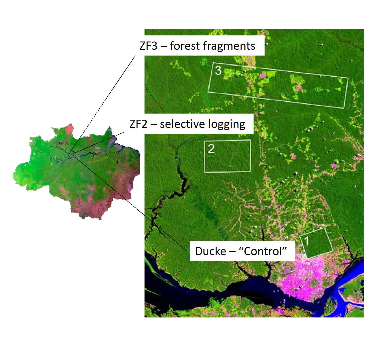
The LTER IAFA site has been running since 1999 and was the first long-term ecological research site in the Amazon. It is situated north of Manaus, central Amazon and includes three sub-sites, with undisturbed terra-firme forest (Reserva Ducke), selective logging (ZF-2 Forest Management Station), and forest fragmentation (Biological Dynamics of forest fragments – BDFFP sites) spread over around 30 x 30 km landscape. Both logging and fragmentation were carried out as controlled experiments to test their effects on biodiversity and ecosystem processes, and thus to outline recommendations for management. The 3 research areas together have 156 permanent monitoring plots, both terrestrial and aquatic, as well as grids of trails for large-scale process monitoring. The information produced has been stored on a public website (https://ppbio.inpa.gov.br/repositorio/dados) where anyone can search data and metadata about the research, as well as the list of publications and all the educational material ( books, identification guides, training course materials) for download.