
species presence
Type of resources
Available actions
Topics
Keywords
Contact for the resource
Provided by
Years
Formats
Representation types
-
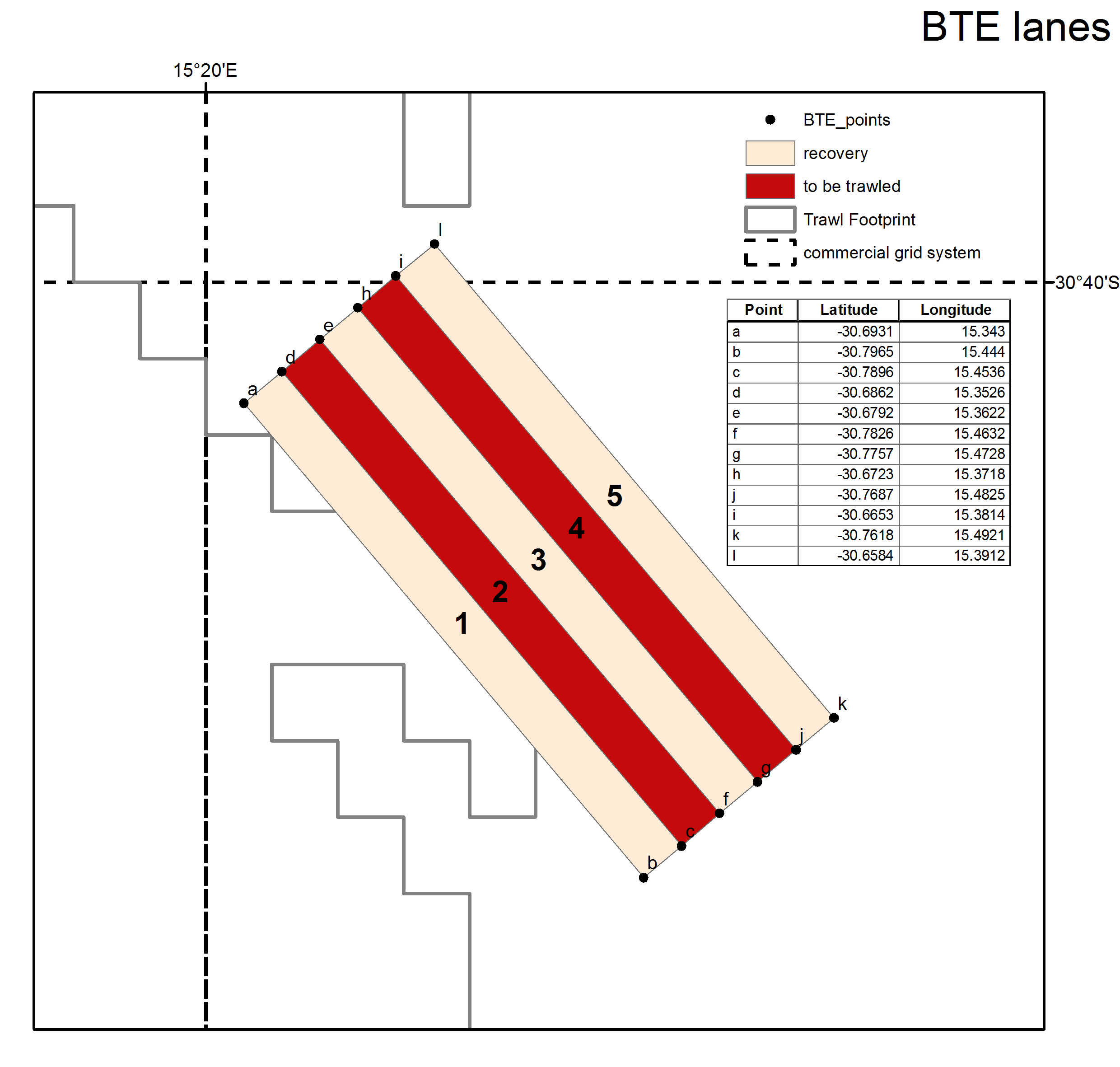
The experimental survey area lies west of Hondeklip Bay, off the west coast of South Africa, near the edge of the continental shelf at approximately 480 m depth. The site consists of 15 x 6 km trawl lanes.
-
Database built by volunteers from the Portuguese Society for the Study of Birds. Each row is a validated record of an observed species. The information on the number of individuals of that species is not reliable.
-
In Doñana both wild and domestic ungulates are present. Livestock (cows, horses, sheep) is controlled by the Park Management authority (Regional Ministry of Environment) through direct counts conducted each month and by sanitary control of cattle (tuberculosis) that is mandatory. EBD-CSIC collects data on wild ungulates (wild boar, red deer and fallow deer) through seasonal (winter, spring and late summer) line transect counts (distance sampling), done by car at the end of the day and beginning of the night. Twelve transects (15 km each) cover different areas of Doñana. Four transects located in the marshes can only be counted in the dry season (late summer). Apart from ungulates, also rabbits and hares are recorded. Park Management conducts additional counts of red deer and fallow deer (population counts) once a year during the mating season (late summer) dividing the National Park into 20 regions. Summaries are all published in annual reports of the Park.
-
The Northern Adriatic Sea is the northernmost basin of the Mediterranean Sea. It is characterized by a shallow depth and by a dominant cyclonic circulation. The oceanographic and meteorological parameters show a marked seasonal and interannual variability. The remarkable river inputs (along the italian coast), the istro-dalmatian current (bringing high salinity and oligotrophic waters from the southern basin), and the notable sea-level range (relatively to the Mediterranean area), represent major forcings of the system. Of ecological relevance are also the urban and industrial inputs and the hydrodynamic exchange between the Northern Adriatic Sea and the lagoons, located along the italian coast.
-
Avic, Mont Avic, (Champdepraz, Aosta), +390576 +5055915; Valle d'Aosta region
-
Data on bird presence and abundance in Doñana is available since the 50ties, even before its protection. EBD-CSIC started standardized monitoring by aerial counts in the 70ties, initially focused on wintering birds but since de early 80ties counts are conducted monthly, and up to 50 bird species are identified in 52 counting areas within the marshes. Terrestrial bird count of main bird concentrations of Doñana have been conducted at the same time (both EBD-CSIC and Park Management) but were not standardized until 2002 by EBD-CSIC. Since then, monthly surveys have been conducted covering about 87 water bodies of the marshes and from fixed observation points (up to 196 water bird species are included). Additionally, each month, a transect (30 km) count of birds (all non-passerine species and Corvus corax) present at the beach and sea shore is done by car. Furthermore, during spring, colonial water bird nests are located and chicks ringed when possible. Several colonies have been monitored since the 80ties. Non-colonial waterbird nests are located monthly during the breeding season using linear transects on horse in the marshes, totalling about 65 km. These transects data are being collected since 2003. Earlier data on non-colonial breeding waterbirds are more disperse, although ringing activities have been done since the 70ties on regular bases.
-
Helgoland Roads summary The Helgoland Roads time-series, located at the island of Helgoland in the German Bight, approximately 60 km off the German mainland (54°11'N 7°54'E), is one of the richest temporal marine datasets available. The time-series was initiated in 1962 at the Helgoland Roads site, which is located between the main island of Helgoland and a small sandy outcrop, the so-called 'dune'. The location near Helgoland is of particular interest because the site is essentially in a transitional zone between coastal and oceanic conditions, which is seen most clearly in the salinity patterns at Helgoland Roads. Initially, the sampling frequency was thrice weekly, but this was increased to daily in the early 1970s. Since then, the high sampling frequency has provided a unique opportunity to study long-term trends in abiotic and biotic parameters, but also ecological phenomena, such as seasonal interactions between different foodweb components, niche properties, and the dynamics and timing of the spring bloom (Grüner et al. 2011; Mieruch et al. 2010; Tian et al. 2008; Wiltshire et al. 2015; Wiltshire et al. 2010). The measured parameters comprise phytoplankton, temperature, salinity, and nutrient analyses. Inorganic nutrients. The taxon list now contains over 350 entities (with 230 distinct species). Both the phytoplankton and chemical dataseries are fully quality-controlled, based on original data sheets and metadata (Wiltshire and Dürselen, 2004; Raabe and Wiltshire, 2009). The phytoplankton time-series is augmented by the biological parameters zooplankton, rocky shore macroalgae, macro-zoobenthos, and bacteria, providing a unique opportunity to investigate longterm changes at an ecosystem scale. Some historic data sets are also available and have been archived in the online repository Pangaea, alongside all core phytoplankton and environmental data sets for Helgoland Roads (Kraberg et al. 2015). Analyses by Wiltshire et al. (2010) have demonstrated the statistical significance of these changes, with temperature since 1962 amounting to 1.7°C (Wiltshire et al., 2010). In tandem with the increases in temperature and salinity, nutrient dynamics at Helgoland Roads have also changed considerably, with phosphate concentrations having declined significantly since 1962. Long-term trends are also seen in the biota, with Diatoms in particular having exhibited an increase in abundance, with a concomitant increase in positive trend for total Dinoflagellates (see also (Wiltshire et al. 2008)). This was not a gradual change, but a rapid shift from negative to positive anomalies around 1998. The exact causes for this are still under investigation. Breaking this down to monthly trends, the swing seems to be largely driven by shifts in autumn and winter. There was also a significant shift in seasonal densities of individual Diatom species (Guinardia delicatula, Paralia sulcata) and in the numbers of large Diatoms (e.g. Cocinodiscus wailesii), which are difficult for copepods to graze. The large Diatom Mediopyxis helysia has recently been observed for the first time and now occurs almost throughout the year, with an intensive bloom in spring 2010 (Kraberg et al. 2012). Generally speaking, the spring Diatom bloom now appears to start later, if the preceding autumn was very warm (Wiltshire and Manly, 2004). It is worth noting that species introductions are also occurring in the zooplankton, with the ctenophore Mnemiopsis leidyi being the most obvious new species (Boersma et al. 2007). References Boersma M, Malzahn AM, Greve W, Javidpour J (2007) The first occurrence of the ctenophore Mnemiopsis leidyi in the North Sea Helgoland Marine Research Grüner N, Gebühr C, Boersma M, Feudel U, Wiltshire KH, Freund JA (2011) Reconstructin g the realized niche of phytopankton species from environmental data: fitness versus abundance approach Limnology and Oceanography methods 9:432-442 Kraberg A, Carstens K, Tilly K, Wiltshire KH (2012) The diatom Mediopyxis helysia at Helgoland Roads: a success story? Helgoland Marine Research 66:463-468 Kraberg AC, Rodriguez N, Salewski CR (2015) Historical phytoplankton data from Helgoland Roads: Can they be linked to modern time series data? Journal of Sea Research 101:51-58 Mieruch S, Freund JA, Feudel U, Boersma M, Janisch S, Wiltshire KH (2010) A new method for describing phytoplankton blooms: Examples from Helgoland Journal of Marine Systems 79:36-43 Tian Y, Kidokoro H, Watanabe T, Iguchi N (2008) The late 1980s regime shift in the ecosystem of Tsushima warm current in the Japan/ East Sea: Evidence from historical data and possible mechanisms Progress in Oceanography 77:127-145 Wiltshire KH, Boersma M, Carstens K, Kraberg AC, Peters S, Scharfe M (2015) Control of phytoplankton in a shelf sea: Determination of the main drivers based on the Helgoland Roads Time Series Journal of Sea Research 105:42-52 Wiltshire KH et al. (2010) Helgoland Roads: 45 years of change in the North Sea Estuaries and Coasts DOI 10.1007/s12237-009-9228-y Wiltshire KH et al. (2008) Resilience of North Sea phytoplankton spring bloom dynamics: An analysis of long-term data at Helgoland Roads Limnology and Oceanography 53:1294-1302
-
The introduction of non-indigenous species (NIS), also known as alien species, is a pressing issue throughout the world nowadays, mostly linked to globalization. Transitional environments are particularly exposed to this threat due to the importation of seafood for either aquaculture or sale. According to the most recent observations, the Mar Piccolo of Taranto hosts 36 NIS positively identified, divided in 13 invertebrates, 15 macroalgae, and 8 planktonic species. This basin ranks third among the Mediterranean hot spots for seaweed introduction, after the Thau Lagoon (southern France) and the Venice Lagoon. Continuous monitoring activities are carried out to early identify new introductions and follow the fate of those already introduced.
-
The Alimini Grande Lake has an elongate shape that develops almost parallel to the Adriatic coastline and overall its extension is 1,37 sqkm. It is linked to the Alimini Piccolo by a canal called Lu Strittu, 1300 metres long and from 10 up to 30 meters wide. The chemical-physical characteristics of the waters such as temperature, salinity and dissolved oxygen concentration have been studied for long time. The average salinity is 26.8 with a minimum of 2.7 in winter and a maximum of 41 in summer. Regarding the temperature, it shows the typical seasonal trend with the least minimum temperature recorded between December and January. The freshwater inflow from Traugnano, Strittu e Zuddeo canals descharges a load of nutrients collected from the catchment area surrounding Alimini Grande. Nevertheless on the basis of the measured nitrogen and phosphorus concentrations the lagoon can be considered mesotrophic, due to the water turnover and above all to the assimilation of nutrients by phytoplankton and bacteria. The lagoon is a nutrient trap, the rates of nitrogen and phosphorus salts in entrance are bigger than those exiting in the sea. For this reason, the lagoon has a relevant ecological function, confining and transferring the nutrients through the food webs within the area and acting as an ecological filter for the marine ecosystems. The Alimini Grande catchment basin has a surface of approximately 71 sqkm and almost 94% of the catchment basin (66 sqkm) is cultivated above all with olives and other sowing fields, requiring more than 300 tonnes per year of fertilizers (nitrogen and phosphorus total) and 3 tonnes of pesticide. The agricultural areas and the artificial surfaces as urban and industrial centers could have a potentially adverse impact on the lagoon because of the run-off waters inflowing through the hydrographic basin that provide high nutrient quantity, organic material and other pollutants. The lagoon is included in the Site of Community Importance (SCI) “Laghi Alimini” (CODE IT9150011) of the “Natura 2000 network”, according to the Habitat Directive 92/43/CEE. Some of the habitats of the lagoon are typical of the dune ecosystem and are of high naturalistic value, as the coastal dunes with junipers considered of priority interest, being present in less than 5% of the EU territory. The Alimini Lake biodiversity is so extraordinary that includes more than half of the vegetable species in Salento. The area is internationally known as located on the avifauna migratory route towards the northern Adriatic coast. In the last years the quantity and the diversity of wintering and migratory aquatic birds, such as the Mallard, Pochard, Coot and other Anatidae have been increasing.Currently the Alimini Lakes are subjects of study by the Department of Biological and Environmental Sciences and Technologies of the University of Salento aiming at the improvement of basic and applied ecological research activities on transitional waters.
-
Regular monitoring activities of the Park's fauna has so far comprised 3 bird species: the golden eagle, peregrine falcon and capercaillie, and 3 mammal species: the Tatra marmot, the chamois, and the brown bear. GIS data layers collected on marmot colonies, preferred areas of occurrence of the chamois (and its range above tree line), as well as roaming areas and occurrence of brown bears (as well as of bear-human conflict hotspots). For birds, spottings, areas of occurrence, number of nesting individuals were monitored. This monitoring will be continued and expanded (to include more species of Community Importance) in a new, currently implemented Park monitoring regime under the new Park Protection Plan (to enter into force soon, as of August 2016).