
stage height
Type of resources
Available actions
Topics
Keywords
Contact for the resource
Provided by
Years
Formats
Representation types
-
The data contain solar radiation, air temperature, temperature depression, wind velocity, wind direction and rainfall from Automatic Weather Stations (AWS) located at Moor House and Helbeck, Cumbria, UK. This data contain a mixture of hourly and daily readings. The data were collected between July 1974 and February 1987 at Moor House and between May 1974 and October 1983 at Helbeck.
-
This dataset contains daily water discharge data from Trout Beck in the Moor House-Upper Teesdale National Nature Reserve in the northern Pennines, Cumbria, UK. Data were automatically recorded at a gauging station located on a weir on the Trout Beck and collated by a variety of staff at the Moor House Research Station on behalf of the Wear and Tees River Board and the National Rivers Authority.
-
Stream water discharge data from the UK Environmental Change Network (ECN) terrestrial sites. The data (stage and discharge) are collected by loggers at ECN's terrestrial sites (where a stream is present) using a standard protocol. They represent continuous 15-minute records from 1993 to 2015. The sites at which these data are collected are: Glensaugh, Moor House - Upper Teesdale, Sourhope, Wytham and Y Wyddfa (Snowdon). ECN is the UK's long-term environmental monitoring programme. It is a multi-agency programme sponsored by a consortium of fourteen government departments and agencies. These organisations contribute to the programme through funding either site monitoring and/or network co-ordination activities. These organisations are: Agri-Food and Biosciences Institute, Biotechnology and Biological Sciences Research Council, Cyfoeth Naturiol Cymru - Natural Resources Wales, Defence Science & Technology Laboratory, Department for Environment, Food and Rural Affairs, Environment Agency, Forestry Commission, Llywodraeth Cymru - Welsh Government, Natural England, Natural Environment Research Council, Northern Ireland Environment Agency, Scottish Environment Protection Agency, Scottish Government and Scottish Natural Heritage.
-
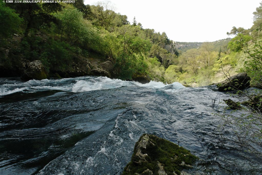
The Environmental Research Observatory Site of Fontaine de Vaucluse – LSBB is an observation and experimental site located in south-eastern France. Observation and experimentations are performed by UMR EMMAH (AU/INRAE) at two different scales: at catchment scale since 1981 (these observations and experiments are reported within the SNO KARST) and at micro-site scale since 2002 at the Low Noise Underground Laboratory (these measurements are reported within the SNO H+ network). Fontaine de Vaucluse is both outstanding and typical of the mediterranean context. This spring is one of the largest springs in Europe with an average discharge over 20 m3/s. It is the main outlet of a large limestone catchment (~ 1160 km2), that extends mainly over natural land, with thick unsaturated zone (800 m in average).
-
UK ECN site. The River Esk rises on the uplands of the North York Moors National Park and is the only major river in the county of Yorkshire that drains directly into the North Sea. The catchment is sparsely populated without the pressures of industrialisation and urbanisation affecting other rivers in the Region. Open moorland characterises much of the catchment and is an important habitat for a wide variety of wildlife. Within the Esk valley there are six Sites of Special Scientific Interest (SSSIs), two of which extend south and cross the boundary of the Derwent catchment. The source of the Esk is upstream of Westerdale, where a series of small streams (becks) known as the Esklets merge to form the River Esk. Many of these moorland streams are affected by natural "flushes" of acidity, as well as iron run-off from natural ironstone strata and old mineral workings, making some of these becks an ochreous-orange colour after periods of rainfall. The combination of the two factors restrict the invertebrate fauna in these head-streams. The majority of the River Esk downstream of the Esklets has very good water quality, with the diverse invertebrate fauna dominated by mayflies, stoneflies, caddisflies and other pollution sensitive groups. This good water quality is also very important in sustaining other species such as salmon, sea trout, dippers and otters. The ECN site is at Briggswath (NGR: NZ 868 081), approximately 2km upstream of the tidal limit. At this point the river is approximately 15m wide, and in normal summer flows the depths vary between 20cm and 30cm.
-
UK ECN site. The River Stinchar is situated in South Ayrshire. It rises close to Loch Doon and flows for 46km before entering the Firth of Clyde at Ballantrae. It has a catchment area of 340km2 and its average flow is 11.2 cumecs. The catchment is largely rural with only a few small and scattered communities. Farming is mostly dairy cattle and sheep rearing, and there have been some pollution problems associated with the latter in particular through spillages of sheep dip chemicals. The upper part of the catchment is extensively forested with conifers for commercial use. The granitic geology and the maturity of the trees have resulted in low pH values in the uppermost routine sampling point. Part of the flow of the upper reaches of the river is diverted by an aqueduct to feed water into the Loch Braden water supply reservoir. The ECN site is situated in the lowest reach of the river where the acidity has been buffered by the base cations in the lower part of the catchment.