
transpiration rate
Type of resources
Available actions
Topics
Keywords
Contact for the resource
Provided by
Years
Formats
Representation types
-
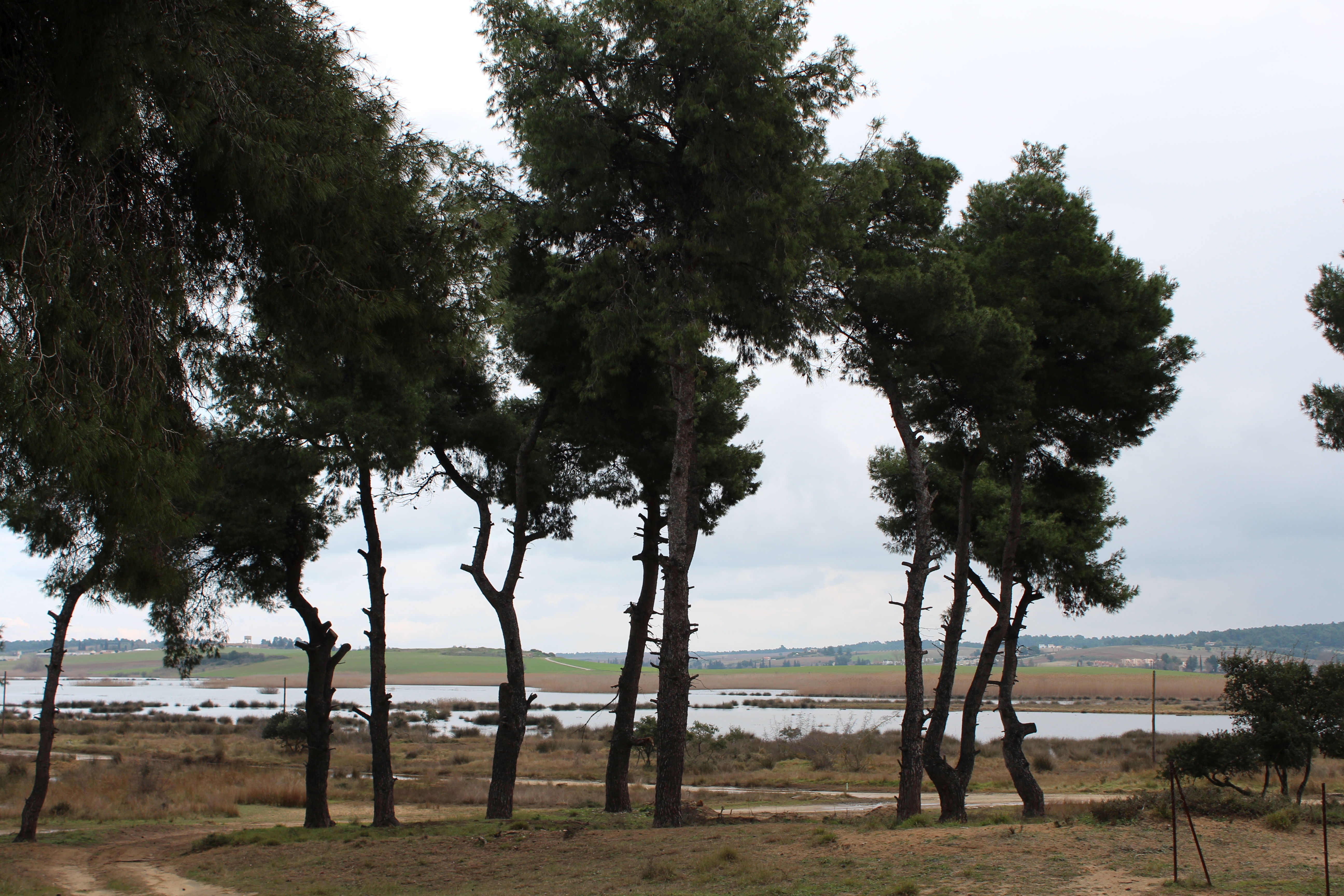
The Sani Environmental Observatory (S.E.O.) is located within a mature, near-coastal Aleppo pine (Pinus halepensis L.) ecosystem at the peninsula of Kassandra, in Chalkidiki, Greece. It is part of the Stavronikita forest, which comprises approximately 300 ha of land covered mainly by forests and to a lesser extend by shrubs and pastures. The Observatory aims primarily at the assessment of the carbon and water balance of this typical low-elevation forest ecosystem to the ongoing climatic shift. Such ecosystems may be prone to the intensified heat and drought events, as well as to the associated insects’ and pathogens’ outbreaks, which are increasingly occurring at the Mediterranean region and particularly at its eastern part. Although Aleppo pines, as well as other Mediterranean pines, are generally adapted to the region’s xerothermic conditions, the in-depth understanding of their ecophysiological and growth responses will allow us to predict the potential of such ecosystems to adapt to climate change. SEO also serves to assess the carbon stocks and fluxes and the contribution of these natural, old-growth ecosystems to carbon sequestration and, thus, to climate change mitigation. S.E.O. is developed by the Forest Research Institute (Lab of Forest Ecophysiology) of the Hellenic Agricultural Organization Dimitra with the support of Sani Resort SA, the owner of the studied forest ecosystem, presenting a nice example of collaboration between the research community and the private sector. Given that SEO is located at a region of high touristic and aesthetic value, close to a wetland and the sea, the Observatory also plans actions to familiarize people with environmental monitoring and the multiple functions and services of the studied Mediterranean ecosystem.
-
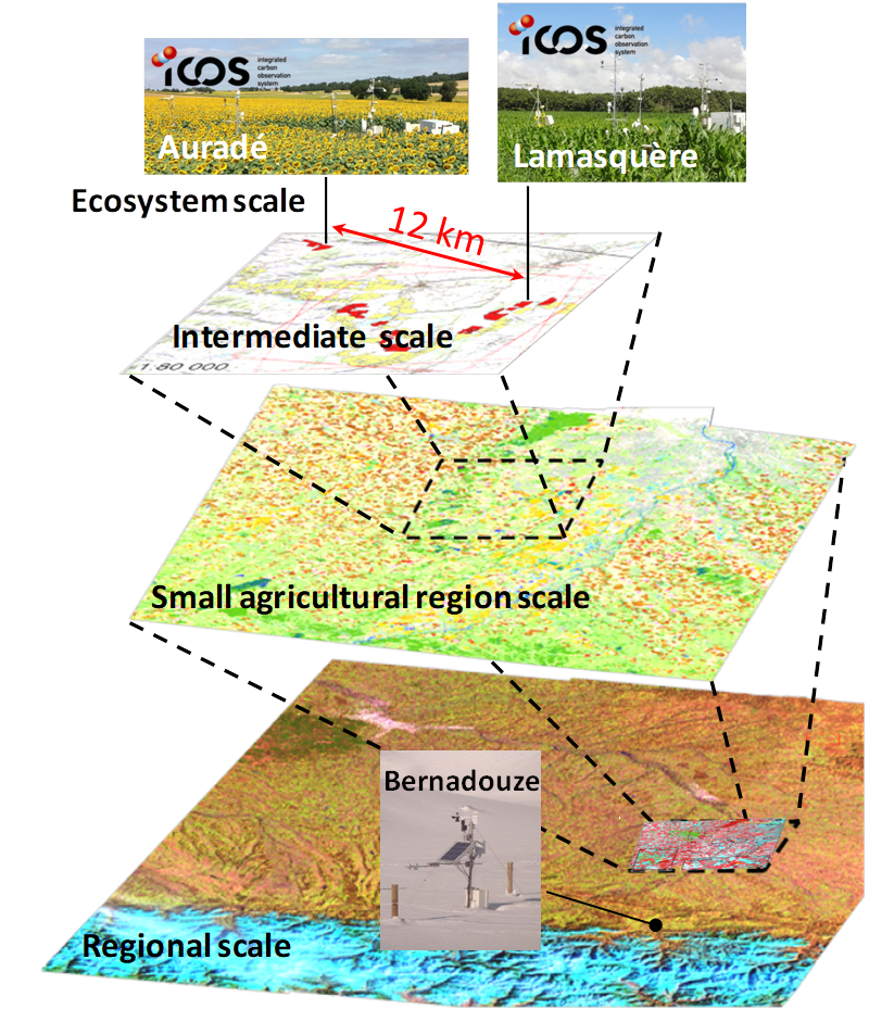
The Regional Spatial Observatory (OSR), labeled in 2007 by the National Institute of Sciences of the univers (INSU), is supported by the Center of Spatial Studies of the BIOSPHERE (CESBIO, OMP). The mission of the OSR aims at documenting on the long term the effects of the climate change and the increasing anthropogenic pressures on the hydrologic and agro-ecologic evolutions in the South-West of France near Toulouse, for various spatial and temporal scales.
-
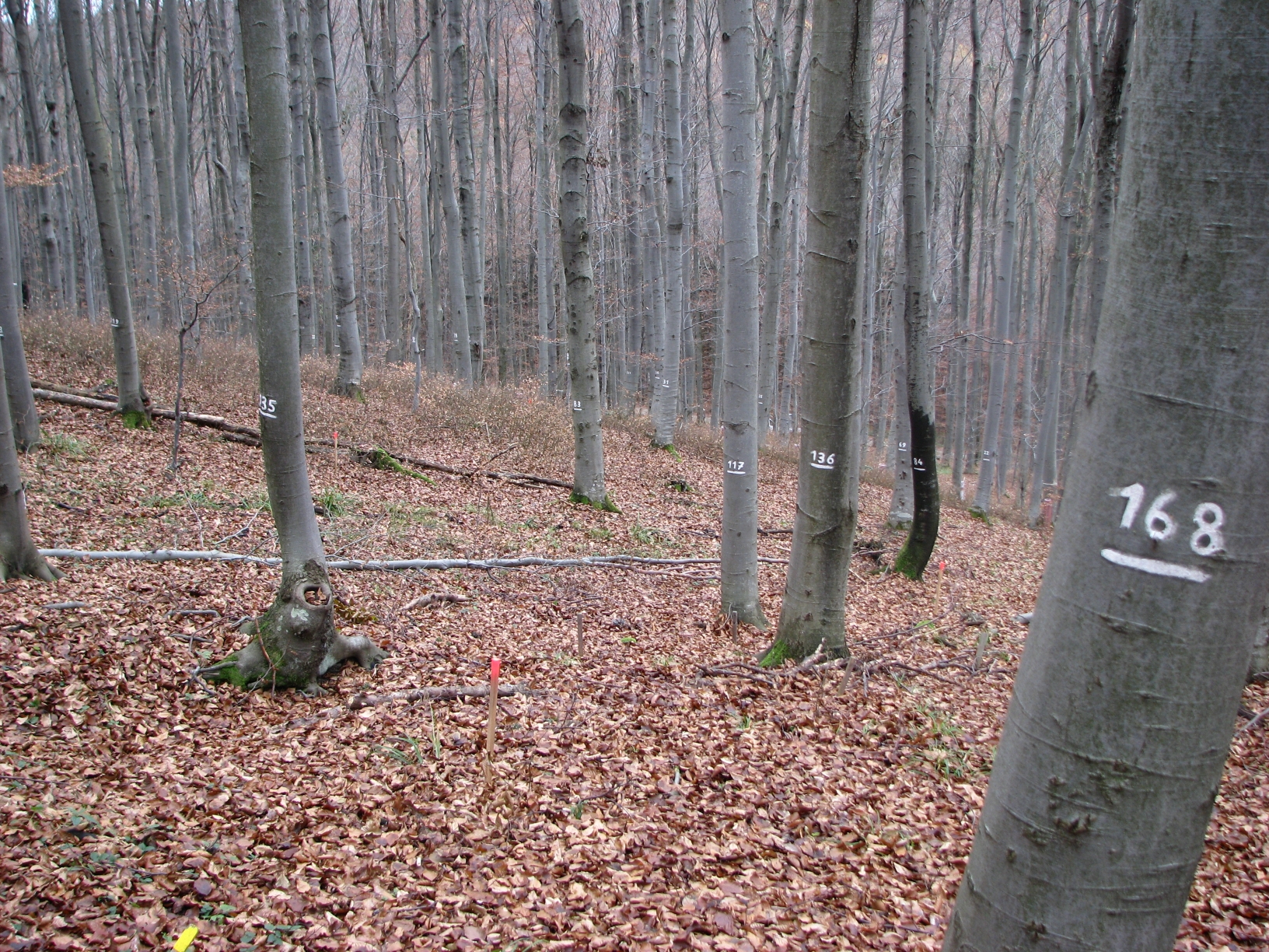
The site Klausen-Leopoldsdorf is part of the European Level II Forest Monitoring System in the frame of the International Co-operative Programme on Assessment and Monitoring of Air Pollution Effects on Forests (ICP Forests). The site was established in 1995 and is, since 2006, part of the LTER Austria network. It is situated in a homogenous 80 years-old managed beech stand about 20km west of Vienna. The LTER-CWN research area in Klausenleopoldsdorf is divided into 3 subplots: a measuring weir, a dendrometer/sapflow measuring facility and GHG-chambers for measuring the fluxes of CO2 and other relevant GHG´s. All 3 subplots were installed in 2019 to collect high-resolution data. The measuring weir is located at about 475m a.s.l and the other subplots (denrometer/sapflow, GHG measuring chambers) are located at about 510m a.s.l. The observed catchment of the measuring weir has an area of 46 hectares. The dominating soil types in the catchment are Planosoils and Stagnosols. The subplots are situated in the near vicinity of the ICP-forest plot.
-

Historically, the role of the Galapagos Islands has been considered critical due to the evolutionary diversification induced by natural and historical isolation. The Galapagos National Park was established in 1959, based on its historical importance associated with Charles Darwin's voyage and its rare and endemic biodiversity, composed of unique vertebrate and plant communities (Rozzi et al. 2010). In 1978, the Galapagos Islands were declared a UNESCO World Heritage Site, a critical factor associated with this national park (Rozzi et al. 2010). The Galapagos Islands are a pristine area with local and regional climates influenced by the interaction of ocean currents and winds driven by the Inter-Tropical Convergence Zone; ITCZ (Conroy et al. 2008, Trueman and d'Ozouville 2010). The long-term programme includes forty natural aquatic ecosystems (lakes, ponds, lagoons and swamps) that will be sampled on the islands of San Cristobal, Santa Cruz, Isabela and Floreana, where possible along a lowland-highland gradient. The number of sampling points will vary according to environmental heterogeneity and the presence of a littoral region, among other factors.
-

Monitoring stations in Aukštaitija NP started functioning in 1993. Aukstaitija station (LT01) was founded in strict reserve zone of Aukstaitija national park in Ažvinčių old forest, Versminis river closed basin. The area of the basin is 101.5 ha. The lowest place is at 159.5 m, the highest - 188.6 m above sea level. Geographical co-ordinates of the basin are: longitude - 26*03*20* - 26*04*50*, latitude - 55*26*00* - 55*26*53*. The climate is characterised as average cold with high humidity and abundant precipitation. The average air temperature is 5.8 C, average precipitation - 682 mm. Length of vegetation period - 189 days. Side glavioacvalic accumulation forms with sand, gravel and stones are typical for river basin and in the western part of the basin, with the decrease of surface altitude transfers into fliuvioglacial terrace delta plain with fine sand, and at the source- into marsh accumulation forms with organic sediments. At the eastern side of the basin, which has higher altitudes, the typical for this basin glavioacvalic accumulation forms transfer into gravel sand. Carbonates start foaming at 45 cm depth (Gulbinas et al., 1996). The saturation of the river water with the oxygen is very weak. The average yearly oxygen concentration equals to 2.9 mg/l (minimal allowable concentration – 6 mg/l). The pH value of the water fluctuates from 7.10-7.75 mg/l, which indicates the alkalisation of the water. Concentration of hydro-carbonate ions varies in the intervals of 148-224 mg/l. Concentrations of sulphates and chlorides are very small. Calcium and magnesium ions are dominating in the media of cations. Concentration of natrium ions is insignificant – 2 mg/l 9DLK=120 mg/l), concentration of kalium ions reaches only tenths of mg/l (DLK=50 mg/l). According to the size of mineralisation the river water could be described as having average mineralisation levels. Concentrations of nitrogen materials (ammonium nitrogen, nitrates) are small, compared to maximum allowable concentrations (DLK) set for surface waters. Concentrations of phosphates are small. Silicium concentrations fluctuate from 2 mg/l to 9 mg/l (Čeponienė, 1997). Main ecosystems Coniferous multi-layered forest stands are prevailing in the basin, which are mainly pine trees with a mixture of spruce. Those stands usually have a second and third tree layer with abundant under layer vegetation. Spruce stands are also of complicated structure. The second and third spruce layer with abundant under layer vegetation are common. Remarkable amounts of territory are occupied by mixed conifer-deciduous or mixed conifer forests. Pure birch stands in more wet habitats in the vicinity of Versminis river source can also be found. According to the forest stand age they are old pure overmature or with accompanying forest stands of several age classes. It is mainly multi-aged and multi-layered over mature pine and spruce stands. In addition The study was based on monitoring data on crown defoliation of more than 3000 Scots pine (Pinus sylvestris L.) trees from 20 permanent observation stands (POS) annually obtained between 1994 and 2009 in Aukstaitija national park (ANP), located in the eastern part of Lithuania (Fig. 1). Over 16yr period mean values of crown defoliation of every sample pine stand were computed annually. Therefore the total number of treatments made N=320. These stands were classified according to stand maturity: 4 sapling stands (45 to 50 years – Table 1, section “Stand maturity”, group 1), 5 middle aged stands (61 – 80 years – group 2), 4 premature stands (81-100 years – group 3), 3 mature stands (101-120 years – group 4) and 4 over mature stands (> 121 years – group 5). Main characteristics of the considered stands are compiled in table 1. All stands represent the prevailing in Lithuania Pinetum vaccinio-myrtilosum forest type.
-
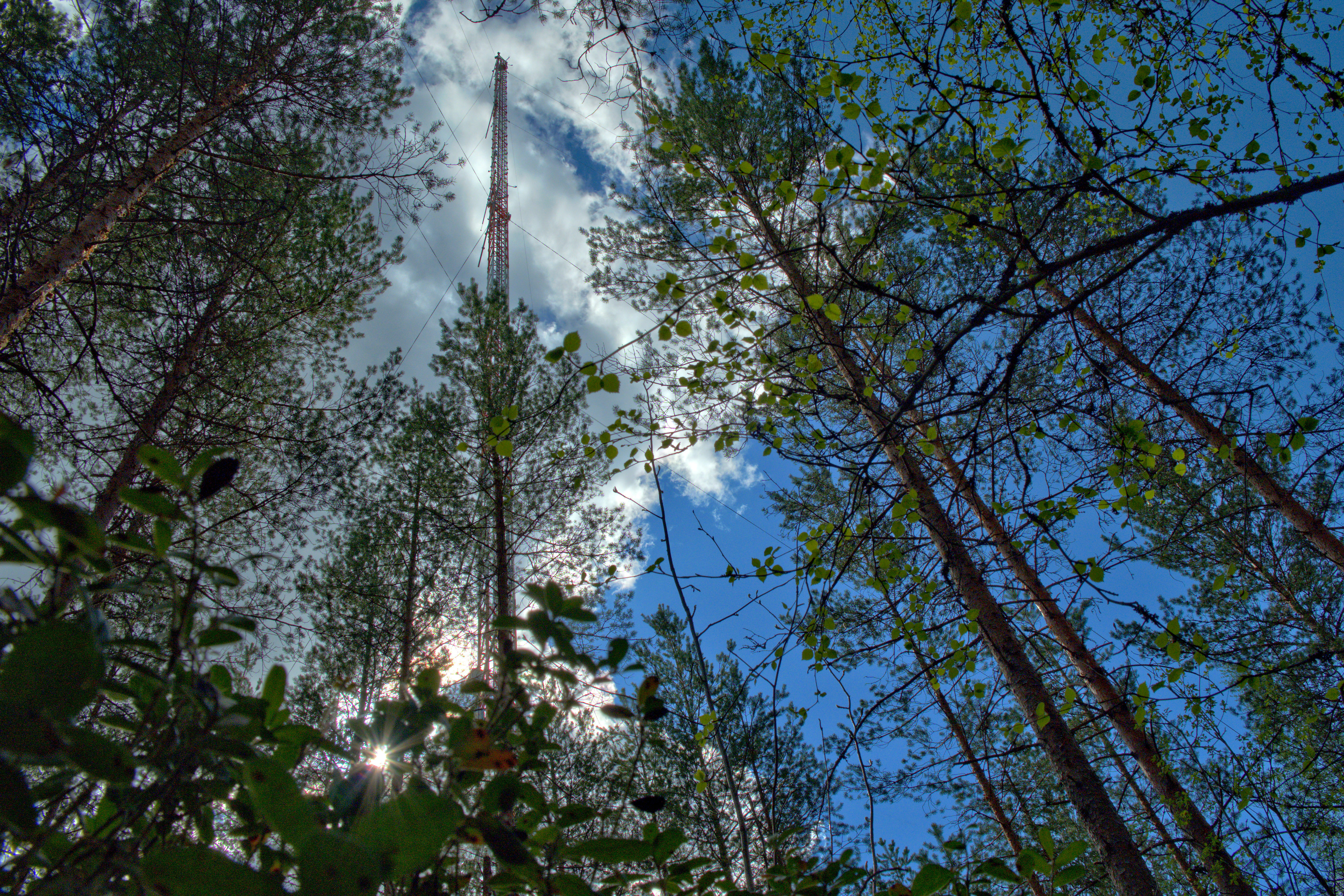
The Hyytiälä SMEAR II site (Station for Measuring Ecosystem-Atmosphere Relations) is situated in the Hyytiälä Forestry Field Station of the University of Helsinki. The site consists is a managed, 60-yr old Scots pine forest stand. The main idea of SMEAR type infrastructures is continuous, comprehensive measurements of fluxes, storages and concentrations in the land ecosystem–atmosphere continuum. The forest measurements are operated continuously since 1996, and include e.g. leaf, stand and ecosystem scale measurements of greenhouse gases, volatile organic compounds, pollutants (e.g. O3, SO2, NOx) and aerosols, in addition to full suite of meteorological measurements. The biogeochemical cycles and vegetation–soil–atmosphere interactions are studied both experimentally and with long-term observations. The site has full carbon, water and nitrogen budgets made over 10 years, and it is a full ICOS ecosystem and atmospheric station. Ecosystem and atmosphere measurements also exist nearby in two open oligotrophic fen sites and a humic lake with forested catchment. Most of the measured data can be retrieved from: https://smear.avaa.csc.fi/
-
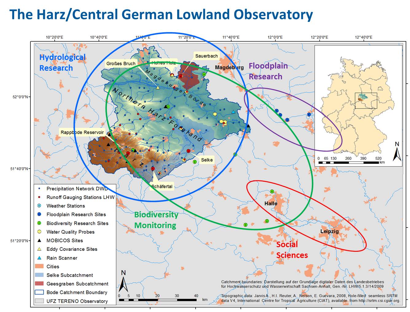
In the framework of TERENO "terrestrial observatories" are set up in selected German regions for climate and landuse change studies. The Harz/Central German Lowland Observatory is one of these observatories that are equipped with a combination of in situ measuring instruments and ground-based, airborne and satellite-borne remote sensing techniques. Additionally a network of biodiversity observation plots is installed. Within the Harz/Central German Lowland observatory the climate feedback experiment SoilCan using a lysimeter network will be realized. Soil monoliths with different vegetation are transplanted along the existing natural gradient in temperature and precipitation within the four TERENO observatories. Within the Harz/Central German Lowland observatory three main intensive test sites have been selected: Sauerbach, 27 ha, forest/agriculture, Schäferbach, 27 ha, agriculture, Selke Catchment, forest/agriculture. Instrumentation and surveys enable: Dense Soil Moisture Monitoring, Groundwater Monitoring, Runoff and Solute Monitoring, Eddy covariance tower (CO2, NO2, CH4, available end 2011), Geophysical Monitoring (ERT, GPR, EM), Airborne Monitoring using Hyperspectrum Imagery (flight campaigns), Soil Respiration Monitoring (available end 2011), Climate station, Deposition station (available end 2011), Biodiversity Assessment, DTS-observation of groundwater-surface water interactions (Distributed Temperature Sensing, using fiberoptics and temperaturprobes), Vadose Zone Monitoring System (in-situ soil water budget observation), Rainscanner (small weather radar, available end 2011). At the GCEF in Bad Lauchstädt opportunities will be given to manipulate climate change and land environment, from which visiting scientists may benefit. This infrastructure is available since 2013. The monitoring, observation, and research activities within the Harz/Central German Lowland Observatory are organized in four main platforms: 1. Hydrological Platform: catchment of the river Bode (shape on the map) 2. Biodiversity Platform (green dots on the map) 3. Floodplain Platform (pink dots on the map) 4. Urban Platform: the city of Leipzig as focus area
-
The Zöbelboden was established in 1992 as the only Integrated Monitoring station in Austria under the UN Convention on long-range transboundary air pollution (CLRTAP). In 2006 it became part of LTER Austria. The Zöbelboden covers a small forested catchment (90 ha) of a karstic mountain range (500 to 950 m above sea level) in the Kalkalpen National Park. Monitoring and research is focussing on climate change effects on forest ecosystems, the forest carbon and nitrogen cycle, biodiversity, and air pollution effects on forested catchments. The Zöbelboden represents one of the best known karst catchments in Europe with long-term data series of the major components of its ecosystems. The site is part of many national and international monitoring and research networks (ICP Integrated Monitoring, EMEP, LTER, forestREplot, SoilTemp, LifePlan, IG-L, EU NEC-D, etc.). The Zöbelboden is managed by the Environment Agency Austria with technical support of the Kalkalpen National Park and the Austrian Federal Forests.