
vapor pressure
Type of resources
Available actions
Topics
Keywords
Contact for the resource
Provided by
Years
Formats
Representation types
-
Vapor pressure of meteorological Station Rudolfshütte
-
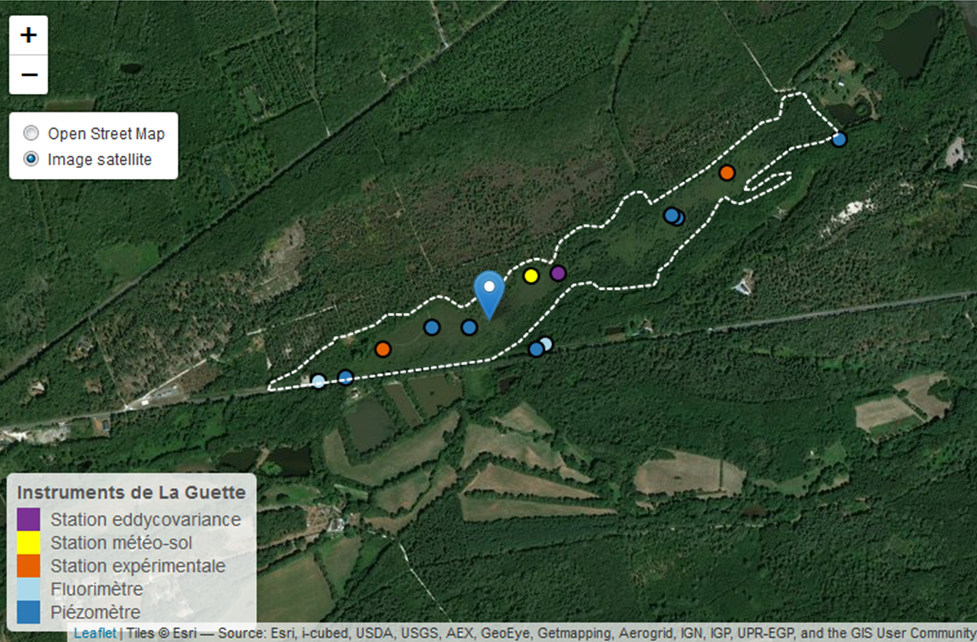
This is a peatland located in Sologne, 80 km south of Orléans. La Guette peatland is one of the four sites of the SNO Tourbières (CNRS). All the sites of the SNO Tourbières are part of OZCAR (French Observatory on the critical zone). The site was hydrologicaly disturbed. Restoration works took place in 2014. A labeling procedure has began to become associated site of ICOS.
-
The SAEON Maputaland Coastal Plain site, Umhlabuyalingana Local Municipality, is a Long term hydro-ecological research platform focused on understanding the relative impacts of climate and land use land cover change on ecosystems services This is a groundwater driven system (sandy unconsolidated aquifer), forming part of the Zululand Aquifer Strategic Groundwater Source Area. There are no surface rivers importing water into the system hence is is dependent on local rainfall for recharge, making it sensitive to changes in rainfall patterns. The site incorporates lake Sibaya, South Africa's largest freshwater lake, which falls within the iSimangaliso Wetland Park, World heritage site and is a RAMSAR site. The region is typified by impoverished and vulnerable communities , with few sources of income. SAEON has instrumented the ground water catchment and its boundaries with raingauges, weather stations, surface renewal systems and an eddy covariance tower. We are also monitoring ground water levels in a number of established monitoring wells. Using a social ecological systems approached, and focused on co-learning, we have developed strong relations with three local communities within the area. The intention is to attract collaborators wishing to co locate instruments as well as perform multidisciplinary work or simply collaborate. We welcome diverse fields of expertise from earth systems science, biodiversity to social and economics sciences.
-
The site is located next to Wettingen in the canton of Aargau, within a natural, mixed forest stand which mainly consists of 150 year-old beech (Fagus sylvatica) and 120-170 year-old spruce (Picea abies) trees. Among others, the site is equipped with two meteorological measurement stations; one is located within the forest stand, the second is co-located in the nearby open-field, allowing to measure the forest stand effect on micro-climate. The following parameters are being measured since 2013: Soil solution chemistry (lysimeters), TREENET, atmospheric deposition (throughfall and bulk deposition), circular vegetation plots, crown condition assessment, diameter and height measurements, foliar analyses, leaf area index (LAI), litterfall, manual circumference band measurements, Ozone visible injury assessment, permanent vegetation quadrats, phenological observations, sapflow measurements, soil matrix chemistry, tree core sampling, automated point dendrometer measurements, automatic circumference band measurements.
-
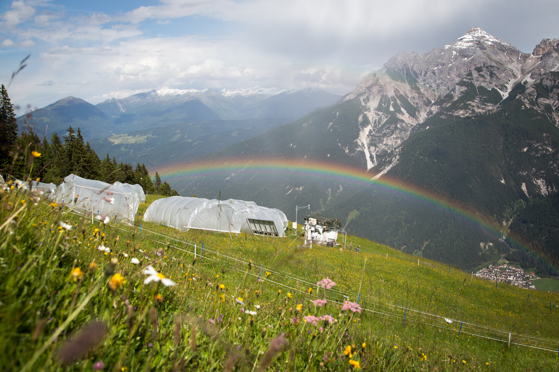
'Tyrolean Mountain Grassland and -Forest' currently consits of 'Stubai - combination of Neustift meadows and Kaserstattalm' (DEIMS.iD: https://deims.org/324f92a3-5940-4790-9738-5aa21992511c). Additional forested research locations may be added in the future.
-
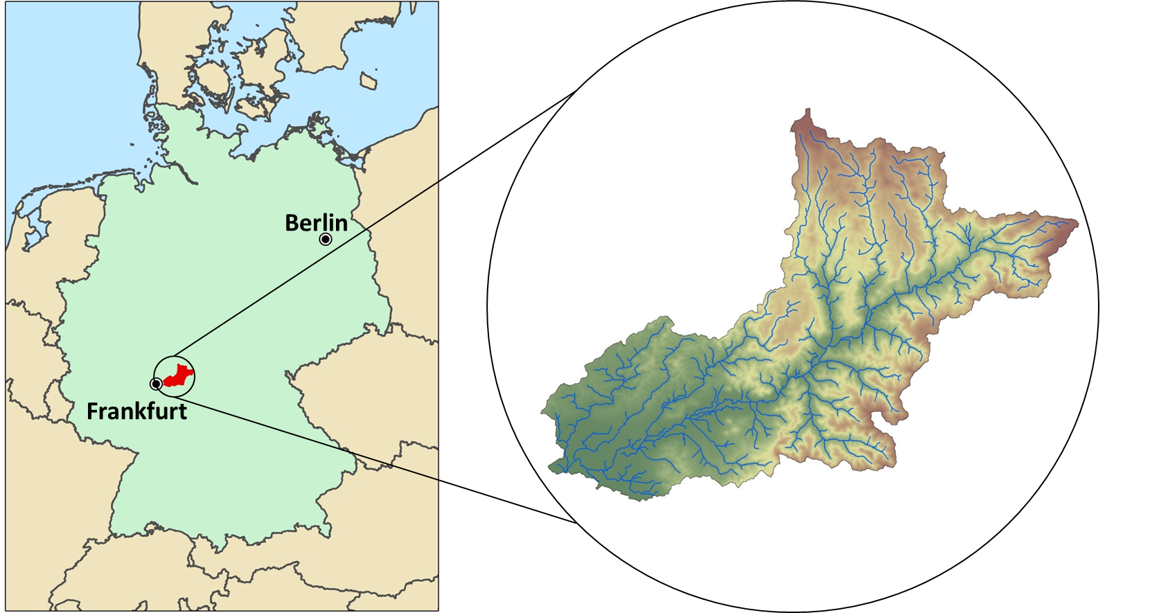
The Rhine-Main-Observatory (RMO) covers the drainage basin of the Kinzig River in Hesse, Germany (~1060km²). Situated at the fringe of the Rhine-Main area, the second largest metropolitan area in Germany, the Kinzig River divides three lower mountain ranges (Rhön, Vogelsberg, Spessart). Therefore, the Rhine-Main-Observatory includes both densely populated areas on the outskirts of the Rhine-Main metropolitan region as well as natural landscapes with little anthropogenic disturbance. This creates a highly diverse mosaic of land uses along a wide gradient of exploitation activities, from vibrant city centers to dense industrial areas; and from intensively and extensively used agricultural land, to heavily managed forests and natural reserves. The RMO was started officially in 2007, however many of the data series started much earlier. The scientific focus of the work in the RMO lies in understanding the role of land use and (micro-) climate in shaping meta-community structures in a fragmented river-floodplain ecosystem. The monitoring comprises a broad variety of permanent biotic and abiotic monitoring sites, as well as additional context-dependent monitoring schemes.
-
Lake Beyşehir, the largest freshwater lake in Turkey as well as in the Mediterranean basin, has a surface area of approximately 650 km2 and mean and max depth of 5–6 and 8–9 m, respectively. The catchment is situated in a semidry Mediterranean climate having an average temperature of 11 °C and an annual total precipitation of 490 mm during 1960–2012. In this period, precipitation values fluctuated between 317 and 716 mm (Beyşehir meteorology station, www.mgm.gov.tr), and the lowest annual average temperature was recorded in 1992 (8.5 °C) the highest in 2010 (13.1 °C). The catchment area of the lake is 4704 km2. The northern and eastern parts of the catchment are flat and intensively used for crop farming, while the western part of the catchment is dominated by mountains covered with forests and small areas of low-intensity agriculture. Nearly half of the catchment (42.7%) is covered by range-brush, 25.5% by agricultural land, and 13.5% by water (including Lake Beyşehir, the inflows, and wetlands), while forested areas (evergreen and deciduous forests) constitute 11.2%. The elevation ranges between 1027 and 2958 m.a.s.l., with an average elevation of 1370 m.
-
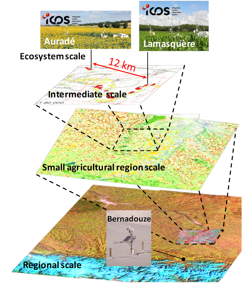
The Regional Spatial Observatory (OSR), labeled in 2007 by the National Institute of Sciences of the univers (INSU), is supported by the Center of Spatial Studies of the BIOSPHERE (CESBIO, OMP). The mission of the OSR aims at documenting on the long term the effects of the climate change and the increasing anthropogenic pressures on the hydrologic and agro-ecologic evolutions in the South-West of France near Toulouse, for various spatial and temporal scales.
-
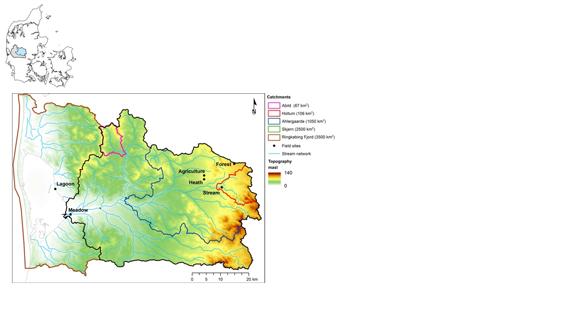
The HOBE experimental catchment is located in the western part of Denmark. The topography of the catchment is relatively flat. The surface elevations in the eastern part of the catchment are about 125 m above sea level at the Jutland ridge and gently decreasing to sea level elevations towards the coast. Alluvial outwash deposits in the form of sand and gravel dominate the central part of the catchment. Towards east, glacial deposits of moraine till are present with a higher content of clay. Also the remnants from the Saale glaciation have higher clay content and the dominant sediment type at these locations is clayey sand. Overall the top sediments are highly permeable with little water retention capability and the stream flow is therefore dominated by groundwater inflow. Based on a classification of the topsoil four soil classes can be identified in the catchment. The by far most dominating soil type is fine/coarse sandy soil. The Quaternary deposits have a thickness less than 50 m in the eastern and central part of the area increasing up to 250 m towards west. The Quaternary deposits are underlain by Miocene sediments in the form of alternating layers of marine, lacustrine and fluvial deposits forming layers of clay, silt, sand and gravel. Further below thick layers of Paleogene clay are found with little permeability and thus acting as a lower impermeable boundary for the aquifer systems. The sand and gravel layers from the Quaternary and Miocene periods form interconnected aquifer systems. The land surface of the catchment is predominantly agriculture and due to the sandy soil characteristics extensive irrigation of the agricultural crops takes place. Based on satellite data the land-use distribution is estimated as follows: grain and corn (55%), grass (30%), forest (7%), heath (5%), urban (2%) and other (1%). The climate of the observatory is of maritime origin and influenced by weather systems coming from the Atlantic Ocean. The weather conditions are variable with frequent precipitation. The prevailing winds from west lead to relatively mild winters and cool summers. The mean annual precipitation is about 1050 mm/year. It varies over the season with highest amounts in the months of October-December and lowest in the months of April-May. The mean annual temperature is 8.20C. The highest mean monthly temperature is in August (16.50C) and the lowest in January (1.40C). Precipitation in the form of snow is highly variable from year to year; in some years, no snowfall occurs and in others, it may stay on the ground for months.
-
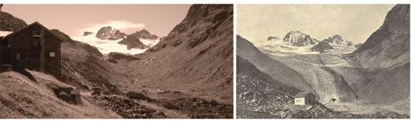
The site is located at the main Alpine ridge in Silvretta group right at the border between Austria and Switzerland. Jamtalferner glacier and it's forefield is subject to scientific reseach for more than 100 years. Current monitoring includes climate, hydrology, glacier mass balance, permafrost, paleoglaciology, society and biotic succession in the periglacial area. In addition to that, several short time research projects are carried out, e.g. concerning glacier albedo. The site inlcudes the are from the highest peaks at 3384 m a.s.l. and the valley further down to the communities of Galtür and Ischgl (1263 m a.s.l.). More information can be found at the website of the environmental education program Jamtal www.umweltbildung-jamtal.info.