
water content
Type of resources
Available actions
Topics
Keywords
Contact for the resource
Provided by
Years
Formats
Representation types
-
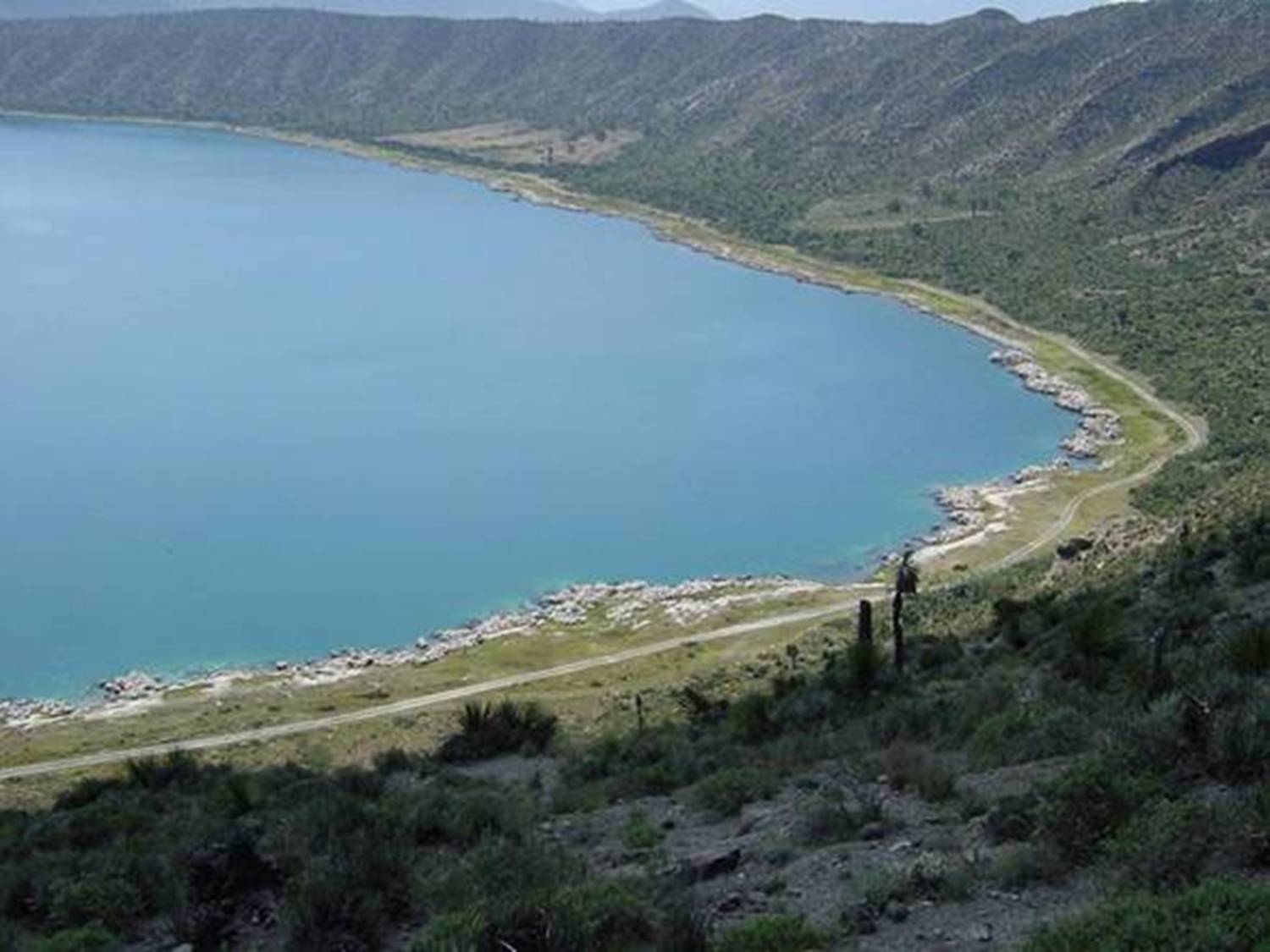
Lago Alchichica se localiza a una elevación de 2300 msnm con una profundidad 62 m y es de agua salobre.Habitan organismos endémicos y se encuentran rocas calizas de particular interés por los microorganismos que viven en ellas. Se encuentra en la Cuenca Oriental de Puebla.
-
The Pinios Hydrologic Observatory (PHO) covers an area of 53 sq.km and is situated within a complex geological/geomorphological environment with forest and agricultural landscapes dominating. PHO was established in year 2015 with the joint efforts of Agrosphere Institute (IBG-3) of Forschungszentrum Jülich (Germany) and Soil & Water Resources Institute of Hellenic Agricultural Organization “DEMETER” (Greece), aiming primarily at developing deep knowledge of water balance at the river basin scale and to improve understanding of the major hydrodynamic mechanisms, thus to improve hydrological modeling and ultimately sustainable water resources management. Moreover, and since agriculture constitutes the major economic activity in PHO, agro-hydrology constitutes one of its top-priority research topics. PHO is located in the River Pinios basin (RPB), which is one of the most productive basins in Greece having a spatial extent of about 11,000 sq.km. RPB is facing a wide range of problems related to water resources management including groundwater overexploitation and quality deterioration triggered by prolonged droughts and poor management practices in the mid-1980s, which affect and jeopardize the regional socio-economic stability and growth. PHO is envisaging to investigate and address critical scientific questions on how to effectively preserve water and soil resources of the basin and to efficiently manage water availability on the basis of natural recharge occurrence.
-
LTER Fulophaza is a high diversity site, both in terms of habitats and species, in the Kiskunság Sand Ridge. It harbors some of the central facilities of the KISKUN LTER, such as the meteorological station and the field research station with accommodation opportunities, as well as highly equipped experimental sites, and a couple of long term monitoring sites and field experiments.
-
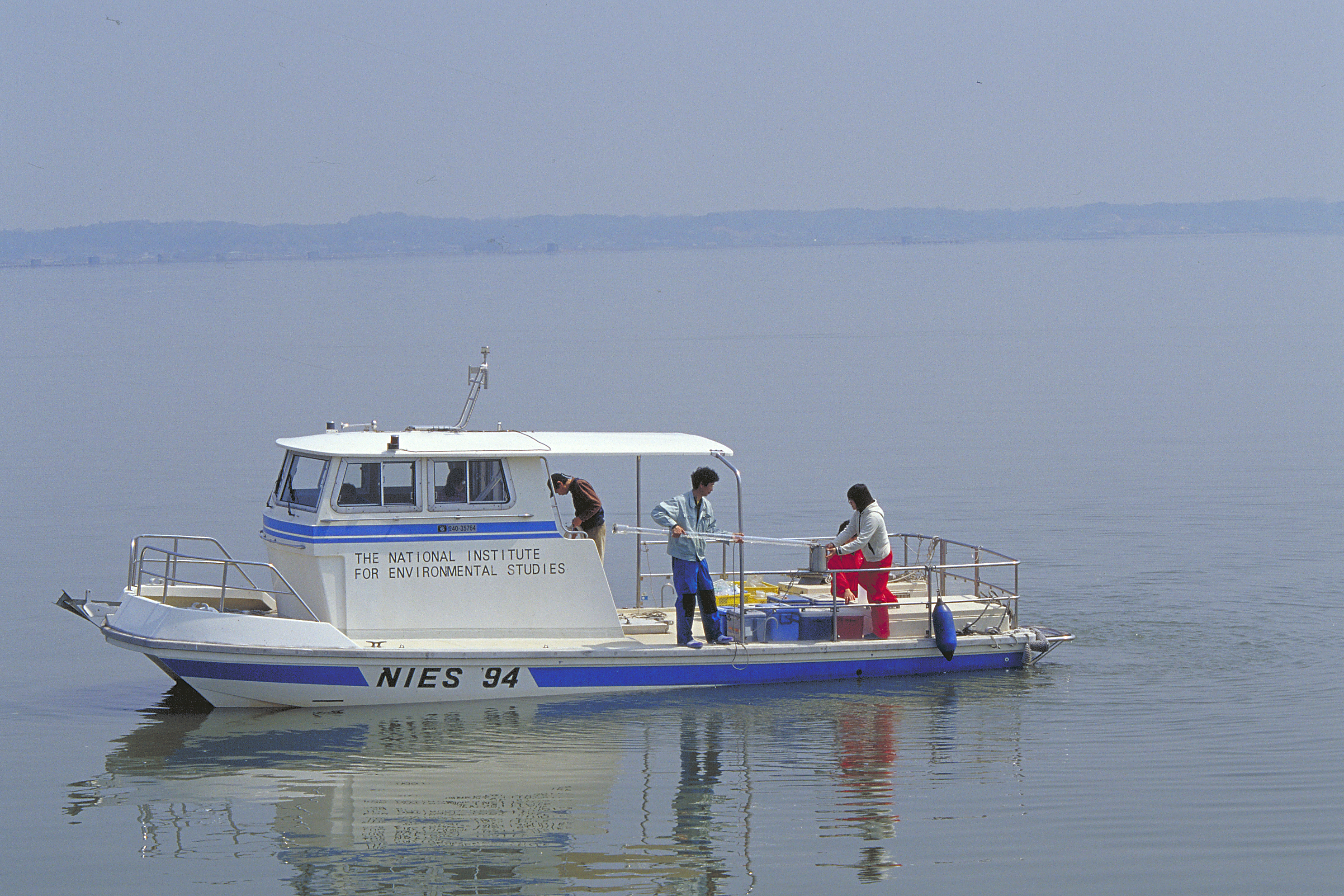
We have been monitoring Lake Kasumigaura, the second largest lake in Japan, monthly for nearly four decades. We have monitored not only environmental variables, water quality, nutrients, and heavy metals, but also plankton (e.g., bacteria, heterotrophic nanoflagellates, ciliates, picoplankton, phytoplankton, zooplankton, mysids), primary production, benthos (chironomids and oligochetes), and fish. To increase data availability and the numbers of data users, we created an English web database (http://db.cger.nies.go.jp/gem/moni-e/inter/GEMS/database/kasumi/index.html) in this research period, and strengthened our relationships with international observational networks. We also provided monitoring data to the Japan Long-Term Ecological Research Network (JaLTER; http://www.jalter.org/index.php?ml_lang=en) and published two data papers in the international journal Ecological Research (Takamura et al. 2012 a, b). We have also started to register fish monitoring data in the Global Biodiversity Information Facility (GBIF) (http://www.gbif.org/dataset/f648085b-8e1c-4a79-bc8d-f45d36296564) .
-

Hydrometeorological observations within 6 embedded catchments (from 0.3 to 3.9 km2). Mediterranean climate with heavy rainfall and flash floods in automn. The geology is mainly granite. The land use is mainly forest. This site is typical of the Cévennes region. More information at http://www.ohmcv.fr
-
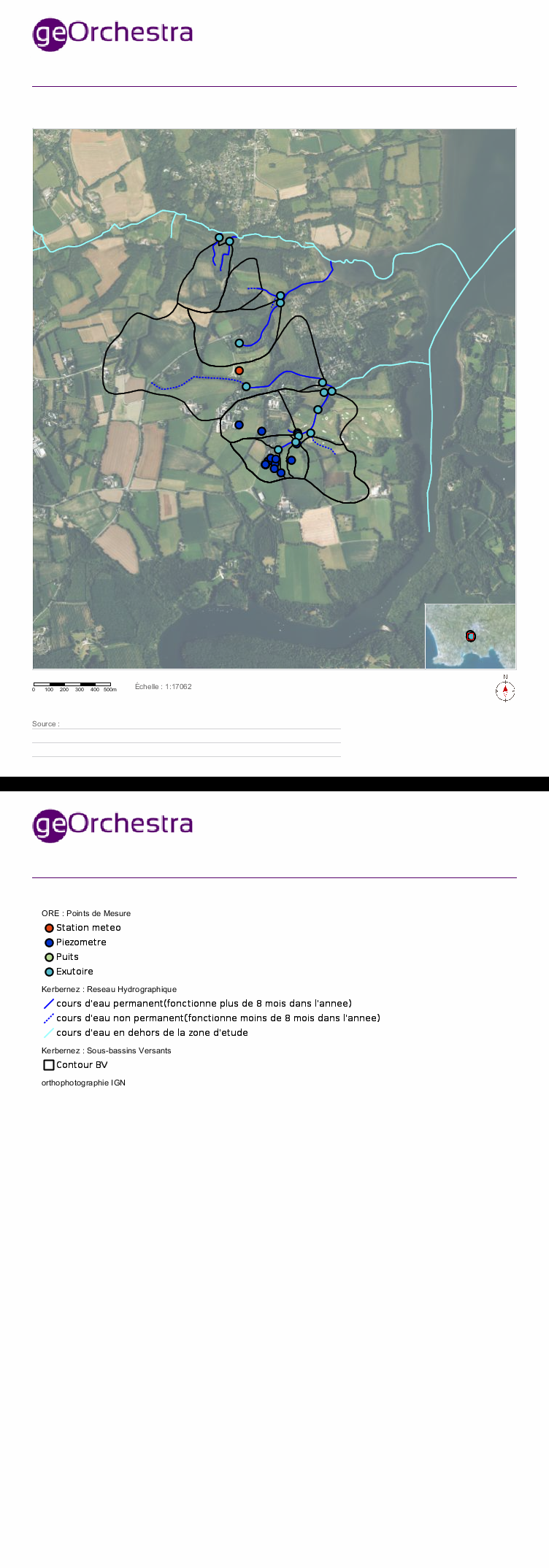
Located in South West of Brittany, western France, the elementary catchments of Kerbernez are underlain by old bedrock and is characterised by a oceanic, humid and temperate climate and by an intensive agriculture. In every catchment, the hydrology is controlled by a shallow aquifer made of the unconsolidated weathered bedrock. The water table in the aquifer is close to the soil surface in bottom land areas of catchment. During storm event, surface runoff occurs mainly over the saturated soils of bottom lands. The Environmental Research Observatory (ERO) AgrHyS focuses on the response times of changing Agro-Hydro-Systems (defined as a catchment influenced by agricultural activity) for hydro-chemical fluxes.
-
The Belgian part of the North Sea (BPNS) covers the most south-western part of the North Sea and is bordered by the English Channel to the south-west and by the central part of the North Sea to the north-east. The BPNS is mainly influenced by water from the ‘channel’ and from freshwater inputs from the Yzer and Scheldt. Long term data series are being collected for this site at different locations, making use of Thornthon Buoy, Simon Stevin Research vessel and an operational Marine Observatory that includes monthly surveys on the BPNS and an array of sensor networks.
-
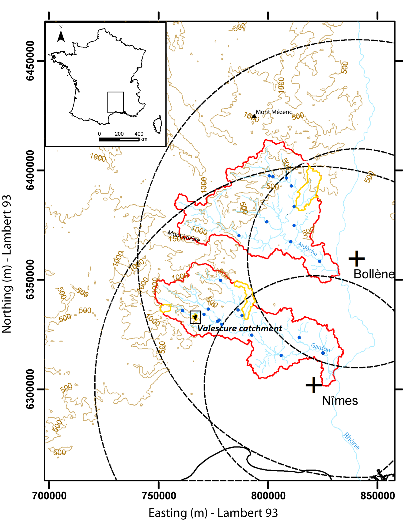
Hydrometeorological observations within 3 embedded catchments (0.9, 2.6 and 14.5 km2). Mediterranean climate with heavy rainfall and flash floods in automn. The geology is mainly shale. The land use is mainly forest. This site is typical of the Cévennes region. More information at http://www.ohmcv.fr
-
Mt. Jumbongsan site has housed the KLTER(Korea Long Term Ecological Research) station run by Ministry of Environment and National Institute of Ecology since 2004. Mt. Jumbongsan is located between Mt. Soraksan and Mt. Bangtaesan and stretches over Gangwon-do, Baekdudaegan in the Korean Peninsula. The well-preserved old-growth hardwood forest represents the vegetation of Mt. Jumbongsan within the core of Mt. Soraksan Biosphere Reserve designated by UNESCO in 1982. Qurecus mongolica and Lindera obtusiloba are the dominant species in the tree and shrub layer, respectively. Research equipment in the site consists of a flux tower, soil respiration measuring system and a V-notch weir. The flux tower is set for measuring the flow of CO2 and the photosynthesis rate and microclimate of the canopy layer in the area, and the soil respiration measurement system for studying correlation between the amount of CO2 from soil microbes and roots of plants and the soil temperature, and lastly the V-notch weir for measuring the portion material flow running through a mountain valley and hydrological studies. Altogether, we are conducting the study of interactions among various taxa using information produced from the equipment.
-
The Lehrforst Rosalia (Rosalia University forest) is about 1000 ha, covered with all major tree species and forest types in Austria (Norway spruce, Fir, Larch, Scots pine, Beech, Oak, etc). The forest area is located in the Rosalia Mountains near the Lower Austria/Burgenland border. The Demonstration Forest (950 ha) was set up in 1972 with an agreement between the Austrian Federal Forests (Österreichische Bundesforste, ÖBf, https://www.bundesforste.at/english.html) and BOKU. Nevertheless, the University is active in this area since 1875; considerable documentation regarding forest description and planning was elaborated by that time. It is located on the western slope of the mountainous ridge called „Rosaliengebirge“ in the southeastern part of Lower Austria (LAT 47°42’N, LON 16°17’ E). Elevation is between 300 and 720 m a.s.l, annual mean temperature of 6.5 deg C and 800 mm annual precipitation. The forest is mainly composed of beech associations (Fagetums) , peripheral also spruce-fir-beech forest association (Abieti-Fagetum). The Key task of the Forest Demonstration Centre ist supporting the educational and research work of the University of Natural Resources and Life Sciences. Accordingly, accommodation, work and teaching facilities are provided. The research focus lies on following areas: · Collection and hold ready of area-based and environmental Data · Establishing and monitoring of sample plots especially for beech growth and treatment related questions · Characterization of local and microclimate · Environmental impacts to forest ecosystems · Monitoring and modelling of small forested watersheds Essential research and educational infrastructure are: · 4 Weather monitoring stations · 2 scaffolding towers for measuring (35m) with instrument cabin · 4 Measuring weirs for runoff monitoring (Watershed 230 ha) · radio linked data collection and on-line hosting · Surveying and Mapping equipments (terrestric and GPS) · Long-term experiment simulating drying and rewetting of forest soils (DRAIN Station) · IT-Room with different Software-packages (GIS, Planning Tools etc.) · Laboratories and work rooms · Lecture Rooms · Accommodation for > 40 people The available data range from base data (GIS-Data), meterological and hydrological time series (since 1990), inventory data of growing stock, data of different plots to measuring data related to numerous projects.