
water reflectance
Type of resources
Available actions
Topics
Keywords
Contact for the resource
Provided by
Years
Formats
Representation types
-
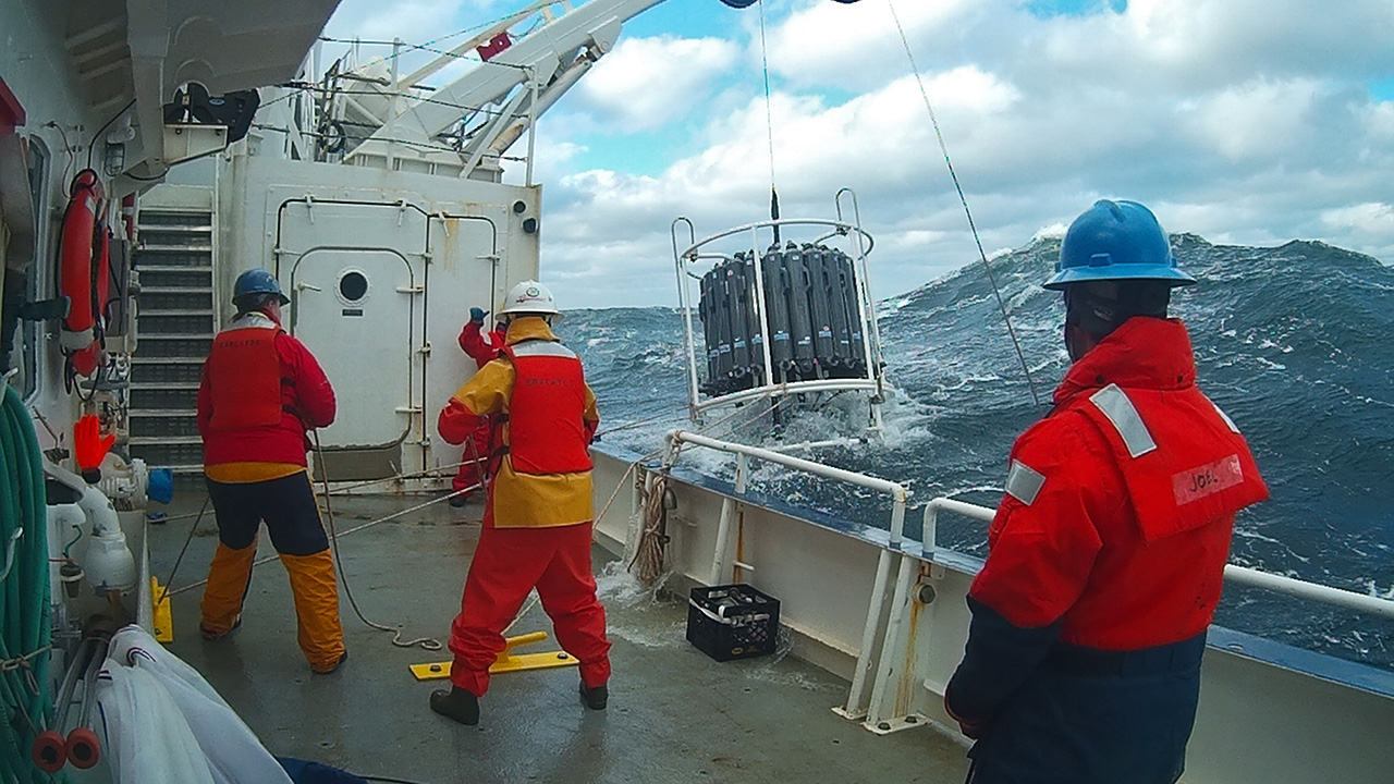
HYBAM observatory runs a network of 17 stations for hydrological, sediment and geochemistry sampling in the Amazon basin. The infrastructure is shared between the partners in each country including France, Brazil, Peru, Bolivia, Colombia and Ecuador. ADCPs are used for river water flow measurements. Samples are processed in different laboratories at Manaus and Brasilia University (Brazil), Lima University (Peru) and Toulouse University (GET laboratory in France). For comparisons with other large tropical rivers, one stations is maintained along the Orinoco River (Venezuela) and Congo River (Congo) HYBAM data are used in a large variety of programs in relation to hydrology, geomorphology, geochemistry, climatology, climate change, carbon cycle, remote sensing and isotopic tracers. The data produced by the HYBAM observatory are made available online on its website (www.ore-hybam.org) to provide to the research community long term assessments on the hydrology of world largest basin.
-
The Northeast US Shelf (NES) ecosystem spans the Middle Atlantic Bight and Gulf of Maine, is a large portion of the NW Atlantic Shelves Province, and is in a coastal biome. The waters over the NES provide an array of ecosystem services including fishing, energy development, shipping, waste disposal, recreation, and conservation. The NES ecosystem, like other productive temperate shelf ecosystems, is characterized by strong seasonality along with high levels of variability in physical forcing at timescales from days to decades, including climate impacts.
-
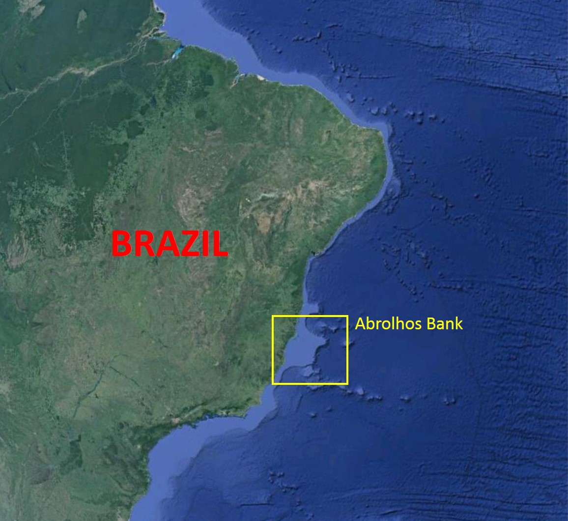
The Abrolhos Bank is located along the eastern Brazilian coast and is characterized by an enlargement of the Brazilian shelf (~46.000 km2), reaching approximately 200 km in width. The Abrolhos Bank encompasses three main megahabitats and a complex bathymetry. Rhodolith beds comprise the largest megahabitat, with 20,904 km² (43% of the mapped area), followed by unconsolidated sediments' megahabitat covering 19,151 km2 (39%) and by the reefal megahabitat with 8844 km2 (18%). Rhodolith beds and unconsolidated sediments are topographically less complex and form larger continuous extensions when compared to the reefal megahabitat, which is structurally complex and more patchily configured, even when examined at the regional scale.
-
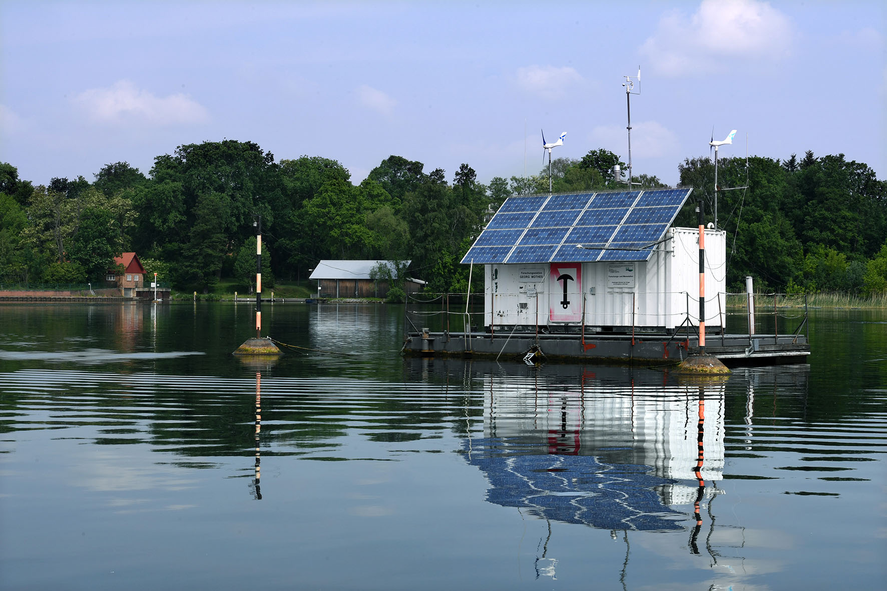
Lake Müggelsee is a shallow (mean depth 4.9 m, max depth 8 m), eutrophic lake situated southeast of the city of Berlin (Germany, 52° 26’ N, 13° 39’ E). The lake is polymictic and usually fully mixed due to the wind fetch of its relatively large surface area of ~750 ha. The River Spree enters the lake from south-east and the outflow is situated in the north-west of the lake. The lake has an average retention time of about 6-8 weeks. Due to its location in a transition zone from a maritime to a more continentally characterized climate, the lake experiences large annual and inter-annual variability in local weather conditions. Data availability spans the time period from 1979-ongoing. Sampling intervals are weekly and biweekly during the winter months. We monitor phytoplankton, zooplankton, and major nutrients and abiotic variables at at weekly temporal scales at 5 different locations across the lake. Fish, macrophytes, MZB, periphyton are sampled yearly. Additionally, we run an automatic lake station (https://www.igb-berlin.de/messstation-mueggelsee) continuously recording water temperature, pH, oxygen, conductivity, fluorescence in -situ in real time. Moreover, the station is equipped with a meteorological station monitoring air temperature, wind, humidity, precipitation, global radiation. Müggelsee is a GLEON (Global Lakes Observatory Network http://www.gleon.org/ ) and an LTER -D site.
-
Processing of time series of satellite and airborne images, with different spatial and spectral resolution, in order to derive water quality maps based on physically based algorithms parametrised with specific optical properties of lake Garda. Generation of spatial and temporal information of different water quality parameters of surface water column and coastal zone. Dedicated actives of calibration and validation of satellite images, algorithms and products.
-
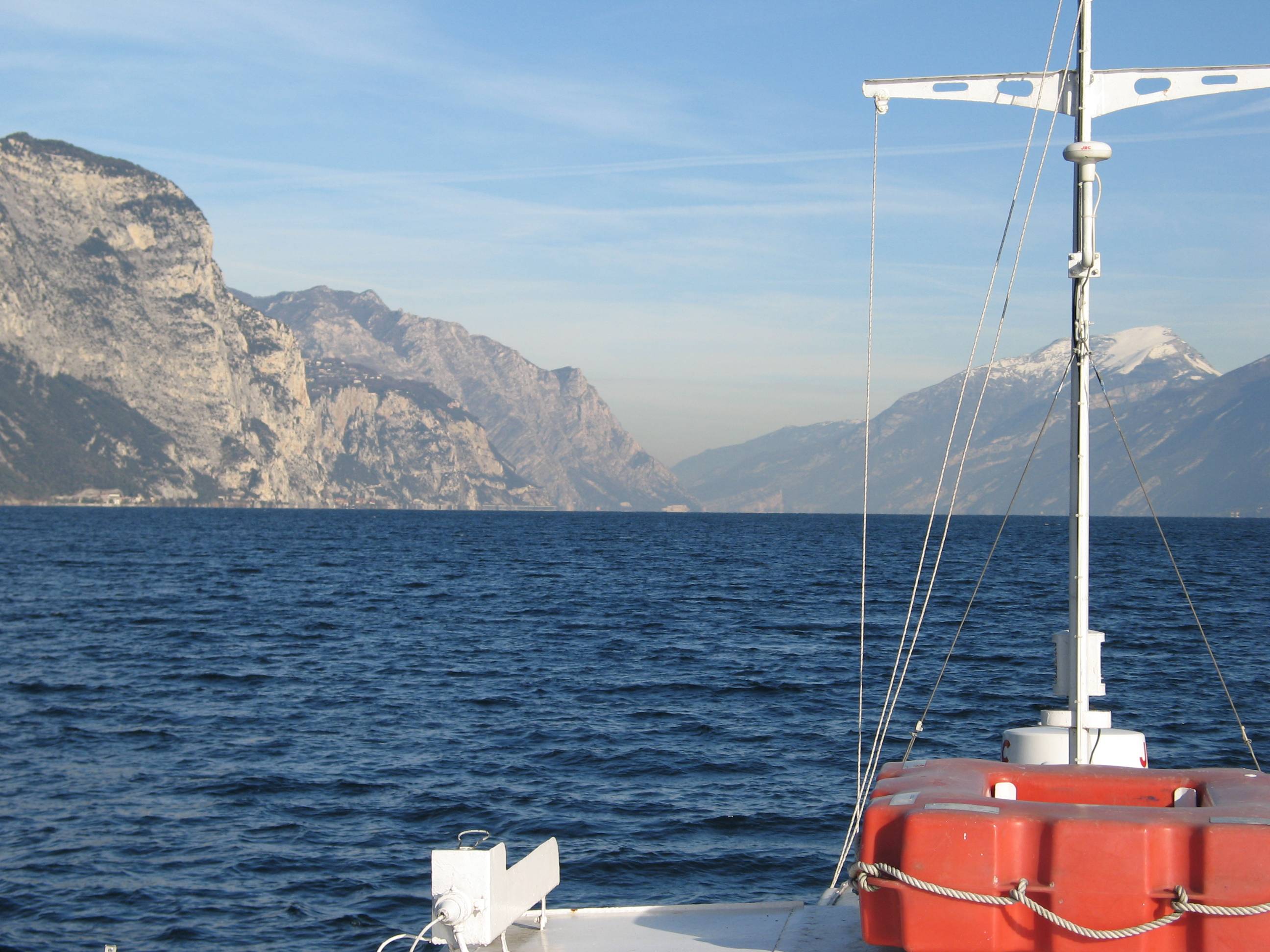
Lake Garda has the largest volume (49 billions of cubic meters) and the most extensive area (368 km2) of Italian lakes. Along with lakes Orta, Maggiore, Lugano, Como, Iseo and Idro, it forms part of the group of deep lakes located south of the Alps in one of the most densely populated and highly productive area of Italy. With a total volume of over 124 billions of cubic meters, these lakes constitute one of the largest freshwater supplies in Europe. Their waters are used for agriculture, industry, fishery and drinking. Moreover, they are an important resource for recreation and tourism thanks to both attractive landscape and water quality. In Lake Garda, sporadic studies were carried out irregularly by various Institutions up to the end of the 1980s. Since the beginning of the 1990s, continuous monthly samplings and measurements were carried out by the Department of Biology of the Padova University (Responsible, Nico Salmaso), with the collaboration of ARPAV. Since 2005 the whole limnological research is performed by the Limnological research group of the Agrarian Institute of S. Michele all’Adige – E. Mach Foundation (S. Michele all’Adige, Trento; coordinator, Nico Salmaso). Since the 1970s, Lake Garda showed an increase in the trophic status, with mean annual concentrations of total phosphorus in the whole water column increasing from ca. 10 µg P/L to 20 µg P/L. In the last 4-5 years of observations, TP showed a stabilisation of the concentrations, around 18 µg P/L. At the community level, annual phytoplankton cycles underwent a unidirectional and slow shift mainly due to changes in the species more affected by the nutrient enrichment of the lake. After a first and long period of dominance by conjugatophytes (Mougeotia) and diatoms (Fragilaria), phytoplankton biomass in recent years was sustained by cyanobacteria (Planktothrix). Other important modifications in the development of phytoplankton were superimposed on this pattern due to the effects of annual climate fluctuations principally mediated by the deep mixing events at spring overturn. Main specific research objectives in this LTER station include: -Changes in the physical, chemical and biological variables at different temporal scales, from months to decades and centuries (paleoecology). Update of the time series of hydrological, climatological and limnological data, whith special attention to lake evolution and effects on biotic communities in relation to ongoing climatic changes. Definition of predictive models. - Identification of the environmental and biotic mechanisms favouring the development of cyanobacteria (including the recent appearence of blooms and new species). Identification of the factors selecting for the development of toxic strains, the production and concentrations of epato- and neurotoxins, and their impact on trophic webs and water usability. The limnological field facilities of the limnological research group include 2 rubber dinghies, 2 multi-parameter probes, a fluoroprobe, a FlowTracker Handheld ADV Sonntek, underwater Quantum sensors, a Kajak corer and an Eckman dredge for sediment sampling. The unit also has several laboratories. These include the hydrobiology and microscopy laboratory, equipped for analyses of basic limnological variables (photosynthetic pigments, dry weight, dissolved oxygen, water turbidity, macrophytes) and of phytoplankton, picoplankton and periphyton samples (microscopes, invertoscopes, fluorescent microscopy, image analysis). The analytical and environmental chemistry laboratory is equipped for analysis of the major ions and nutrients (phosphorus, nitrogen and silica), as well as organic molecules (with focus on cyanotoxins) by means of spectrophotometry, ion chromatography and Liquid Chromatography-Mass Spectrometry (LC-MS). We have access to genetic laboratories equipped with the principal analytical tools, i.e. PCR, electrophoresis, and sequencing. The data collected at monthly frequency since 1991 includes water temperature and oxygen. Phytoplankton was collected since 1993, while complete data recording (including chemistry and zooplankton) begun in 1995.
-
The LTSER Zone Antarctique belongs to LTER-France network and is located in Antarctica (Adelie Land), French sub-Antarctic Islands (Crozet archipelago, Kerguelen Islands, Saint-Paul et Amsterdam Islands) and southern ocean. General information below concerns Kerguelen Islands. The ZATA measures the impacts of climate change and human activities on antarctic and sub-antarctic ecosystems.
-
Sanjiang Plain Marsh Ecological Experimental Station (SJM) is located in one of the largest marshes distribution areas, Sanjiang Plain, which is a low plain formed by the Heilongjiang River, Songhua River, Wusuli River. The station (133°31′E,47°35′N) has an altitude of ~56 m.a.s.l, belongs to the temperate continental monsoon climate zone, with the mean annual temperature of 1.9℃, and annual rainfall of ~600 mm. The area has an annual frost-free period of 125 d and is a typical seasonal frozen area with the freezing and thawing period from early November until the middle of June in the next year. The dominated vegetation composition are Carex lasiocapa, Carex pseudocuraica, Carex meyeriana, Glyceria spiculosa, Deyeuxia angustifolia, and the soil types are mainly meadow bog soil, humus bog soil and gley white paper clay, white pulp meadow soil, etc.The main crops are soybeans and rice in this area.
-
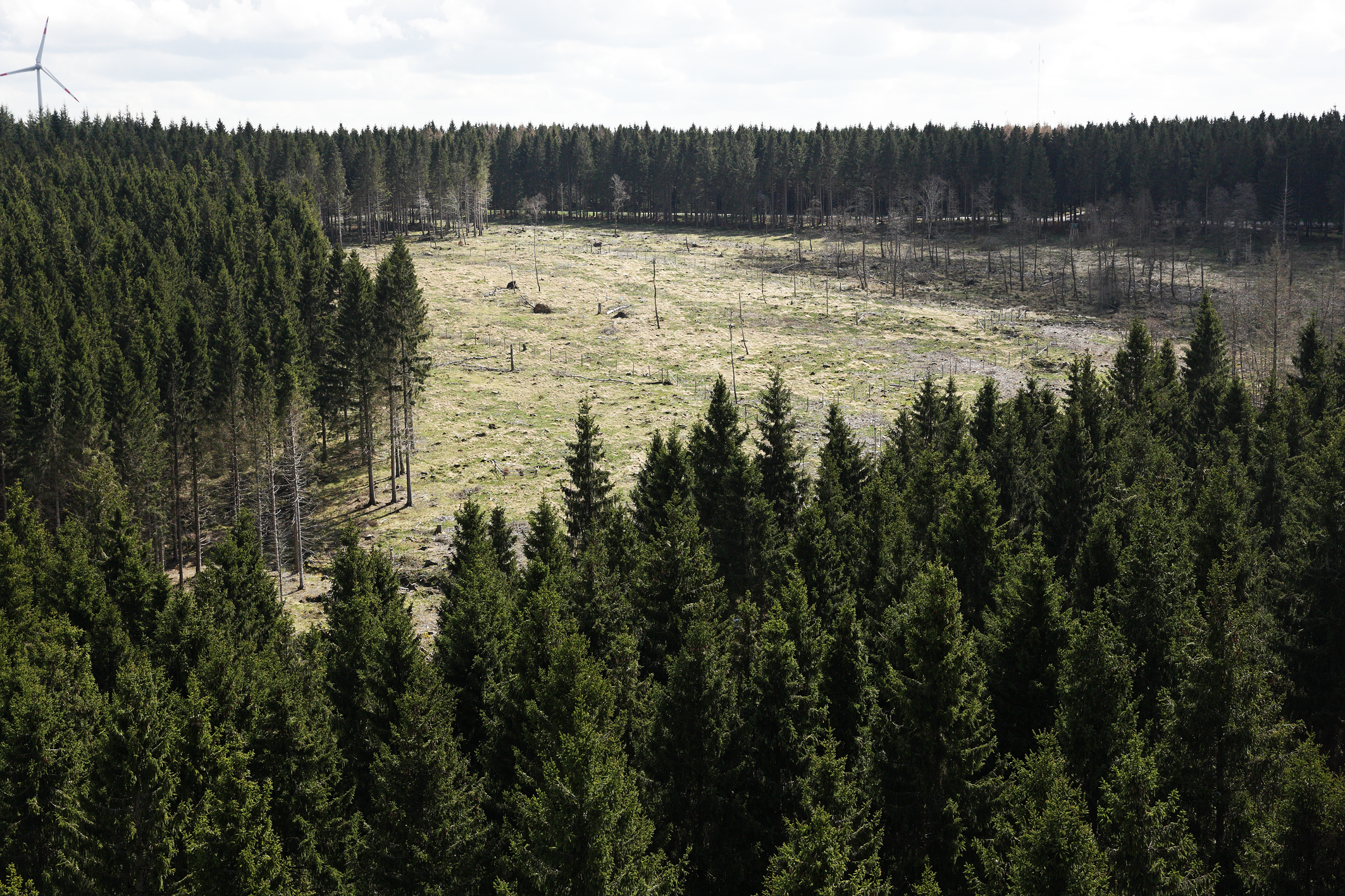
The Wüstebach catchment is located in the Eifel National Park and covers an area of 38.5 ha, with mean altitude of about 610 m. The geology is dominated by Devonian shale, which is covered by a periglacial solifluction layer of about 1–2 m thickness. Cambisols and Planosols have developed on the hillslopes, whereas Gleysols and Histosols have formed in the valley. The main soil texture is silty clay loam and the litter layer has a thickness between 0.5 and 14 cm. The mean annual precipitation is about 1200 mm. Norway Spruce planted in 1946 is the prevailing vegetation type. During late summer/early autumn of 2013, trees were almost completely removed in an area of 9 ha by the national park forest management in order to promote the natural regeneration of near-natural deciduous forest from spruce monoculture forest.
-
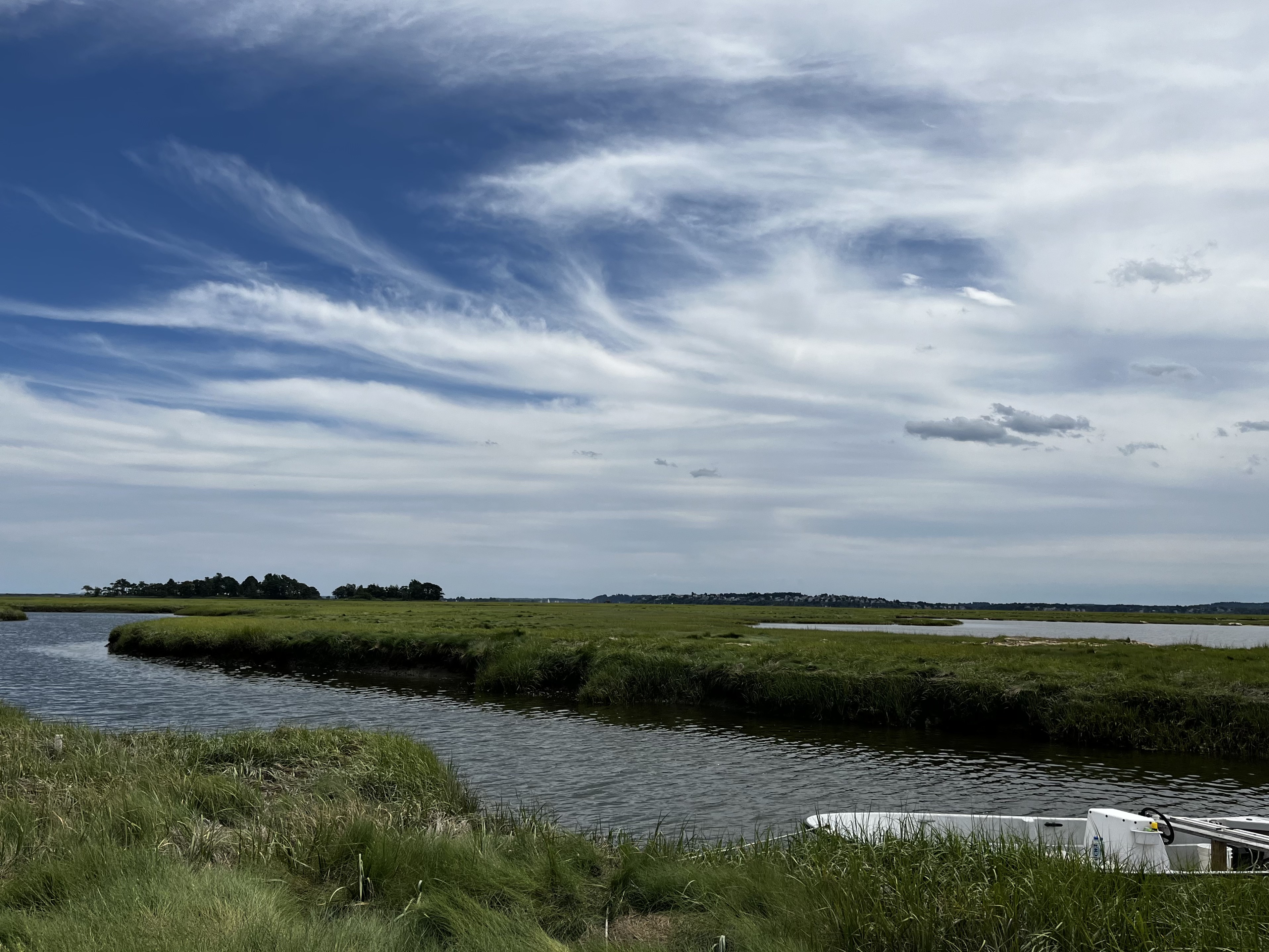
The Plum Island Ecosystems (PIE) LTER research site consists of coupled watersheds and estuaries in northeastern Massachusetts, USA. The Ipswich River (400km2), Parker River (161km2), and Rowley River (39km2) basins make up the watersheds of the system. The watersheds lie within the Boston Metropolitan region. Population density is about 250 people per km2. The 25 km long (16 miles) macrotidal Plum Island Sound estuary contains salt marsh, dominated by marsh hay (Spartina patens) and smooth cordgrass (Spartina alterniflora), fresh marsh, dominated by cattail (Typha), intertidal flats, and open water tidal creeks and bays. This is the largest wetland dominated estuary in New England and it supports extremely productive commercial and recreational soft-shell clam and striped bass fisheries. We have been investigating the ecology of Plum Island Sound estuary since the late 1980s with support primarily from the National Science Foundation. (NSF) We were part of NSF Land Margin Ecosystems Research program in the early 90’s. The site became part of the NSF's Long Term Ecological Research (LTER) Network in 1998. The Plum Island project is one of only 4 LTER sites that studies the effects of human activities in watersheds on estuaries. The PIE LTER has developed an extensive database open to the public via the Internet that includes our results from long-term field observations and experiments in the Ipswich, Parker and Rowley River watersheds and the Plum Island Sound estuary.