
water volume
Type of resources
Available actions
Topics
Keywords
Contact for the resource
Provided by
Years
Formats
Representation types
-
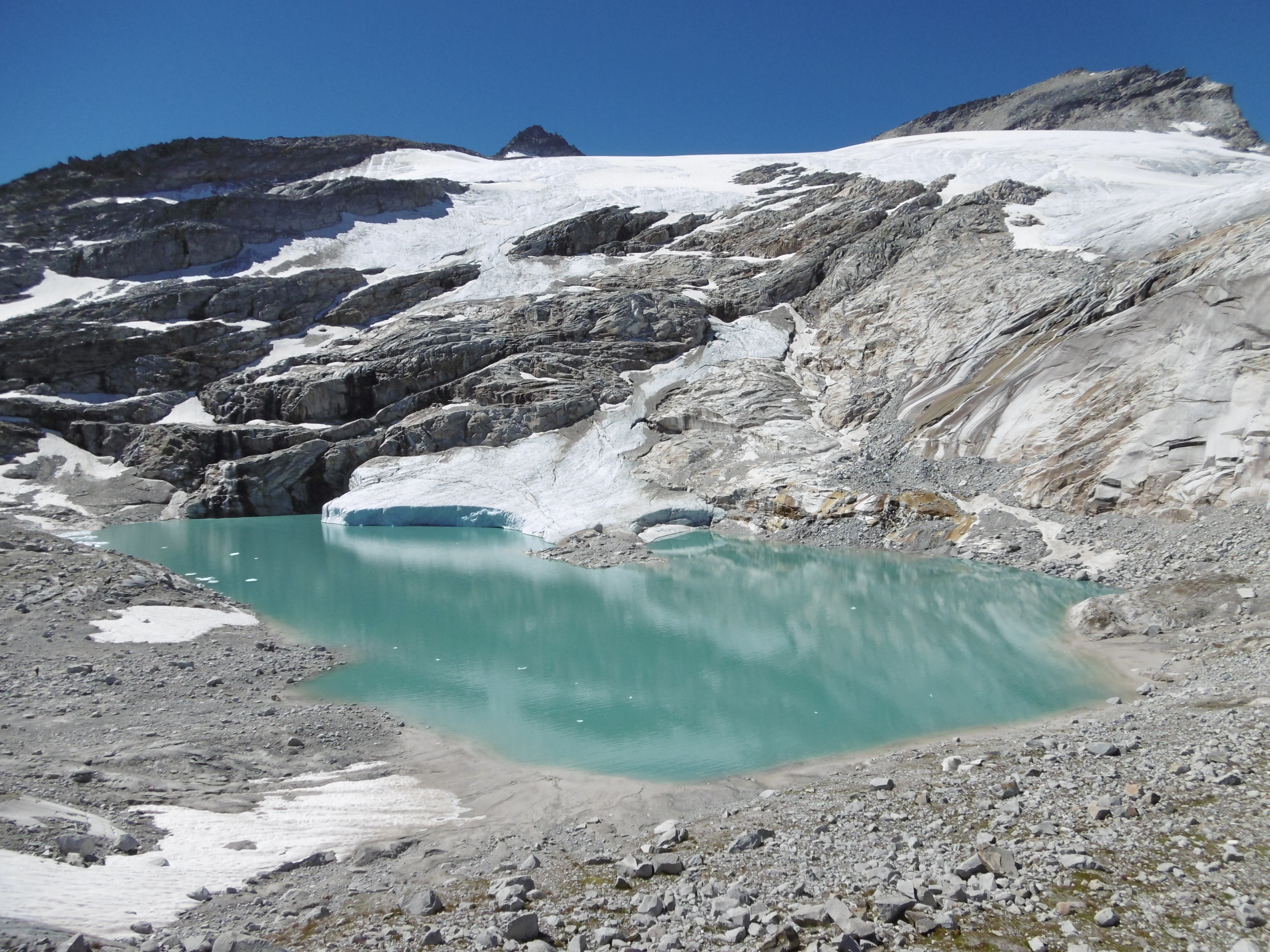
Stubacher Sonnblickkees (SSK) is located in the Hohe Tauern Range (Eastern Alps) in the south of Salzburg Province (Austria) in the region of Oberpinzgau in the upper Stubach Valley. The glacier is situated at the main Alpine crest and faces east, starting at elevations close to 3050 m and in the 1980s terminated at 2500 m a.s.l. It had an area of 1.7 km² at that time, compared with 1 km² in 2013. The glacier type can be classified as a slope glacier, i.e. the relief is covered by a relatively thin ice sheet and there is no regular glacier tongue. The rough subglacial topography makes for a complex shape in the surface topography, with various concave and convex patterns. Direct yearly mass balance measurements were started in 1963, first for 3 years as part of a thesis project. In 1965 the project was incorporated into the Austrian glacier measurement sites within the International Hydrological Decade (IHD) 1965 - 1974 and was afterwards extended via the International Hydrological Program (IHP) 1975 - 1981. During both periods the main financial support came from the Hydrological Survey of Austria. After 1981 funds were provided by the Hydrological Service of the Federal Government of Salzburg. The research was conducted from 1965 onwards by Heinz Slupetzky from the (former) Department of Geography of the University of Salzburg. Along with the mass balance measurement lenght variations and volumen changes where conducted repeatetly. The SSK was mapped several times on a scale of 1:5000 to 1:10000. Length variations have been measured since 1960 within the OeAV glacier length measurement programme. In recent years, the glacier has disintegrated faster, forced by the formation of a periglacial lake at the glacier terminus and also by the outcrops of rocks (typical for the slope glacier type), which have accelerated the meltdown. The formation of this lake is well documented. The glacier has retreated by some 600 m since 1981. - Since August 2002, a runoff gauge installed by the Hydrographical Service of Salzburg has recorded the discharge of the main part of SSK at the outlet of the new Unterer Eisboden See.
-
GIS thematic layers on the Park's hydrography: mountain lakes/ponds, streams. Bathymetric data, boundary of catchments, waterfalls, water resources, water uptake points, etc. Also available spatial hydrogeology data (springs).
-
Øvre Heimdalen is located by Valdresflya in the eastern part of Jotunheimen on the border between the municipalities of Øystre Slidre and Vågå. The valley floor, which is oriented east-west, is at an altitude of 1,100 metres. The surrounding mountains reach over 1,800 m above sea level. Birch forest grows on the south-facing valley side, but the rest of the area is above the tree line. Research activity in Øvre Heimdalen began in 1957 with documentation of the trout population in Øvre Heimdalsvatn, and how the biomass, growth rate and age composition of the population were affected by environmental conditions.
-
National Network Name : rbv_czo Nested watersheds in humid tropical forest of Cameroon from the Mengong experimental watershed (0.6 km2) to the Nyong River at Olama (18500 km2) Granitoid bedrock secondary forest low anthropogenic pressure Monitoring initiated in 1994 for some parameters more details at : https://mtropics.obs-mip.fr/
-
Piburger See is a small mountain lake in the Eastern Alps (Austria) and was part of the OECD study on eutrophication (OECD, 1980). This lake experienced cultural eutrophication during several decades in the 20th century. In the 1950s and 1960s, recreational activities increased with a concurrent rise in tourism, and increasing amounts of fertilisers were used on nearby fields (Pechlaner, 1968). This resulted in enhanced primary production and rising hypolimnetic oxygen depletion in the lake (Pechlaner, 1979). Lake restoration started in 1970 by exporting anoxic and nutrient-rich hypolimnetic waters with an Olszewski tube (Pechlaner, 1971, 1979). External nutrient loading was reduced by altering fertiliser application and by diverting sewage from a public bath (Psenner, Pechlaner & Rott, 1984). After the installation of the Olszewski tube in June 1970, phytoplankton biomass increased, accompanied by an increase in chlorophyll "a" and total phosphorus (TP) (Rott, 1983; Tolotti & Thies, 2002). The period from 1970 until 1988 was characterised by a marked increase in the filamentous cyanobacterium Oscillatoria limosa C.A. Agardh, which became the dominant algal taxon in the lake and contributed up to 40% to the mean annual phytoplankton biovolume (Rott, 1976; Wolf, 1991). The response of phytoplankton biovolume to lake restoration was delayed by two decades and re-oligotrophication of Piburger See began during the late-1980s (Pechlaner, 1979; Rott, 1983; Pipp & Rott, 1995). At present, Piburger See is oligomesotrophic (Tolotti & Thies, 2002). Since the early 2000s, chlorophyll "a" and phytoplankton biovolume values suggest a reversing trend in lake trophic status with a rising contribution of diatoms including blooms of Asterionella formosa (Tolotti et al., 2005; Tolotti net al. 2012, Thies et al. 2012). Monitoring of lake water quality, control of deep water siphoning discharge and operation of gauges are current activities at this site. A rowing boat for lake water sampling is available. A smaller part of the lake has the status of a research area. During summer, tourism is an important factor at this site (public bath, rowing boats, angling, swimming, walking).
-
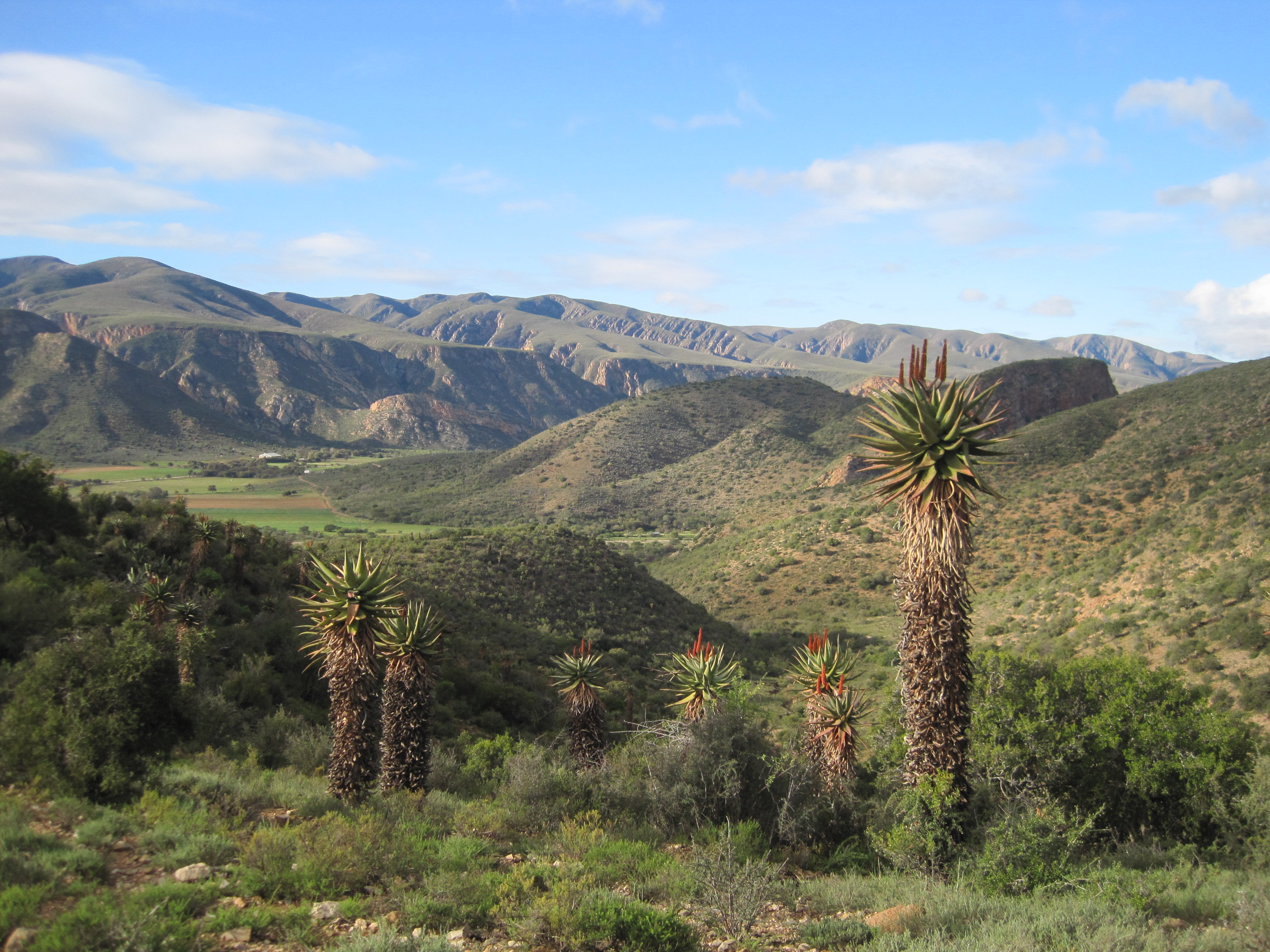
This site covers the catchment area of the Baviaanskloof River and surrounding Baviaanskloof Mega-Reserve area, where ecological, agricultural and social systems are managed collaboratively in order to promote sustainable use of the landscape.
-
"Chornohirskiy geographical station" (CHGS) by Ivan Franko National University of Lviv (LNU) is located at the upper part of the Prut river basin, at 17 km from the town Vorokhta, Ivano-Frankivsk region and is within Carpathian National Nature Park (48˚10̍ .45 N; 24˚34̍.32 E). The station was founded in 1978 and is in operation by now.
-
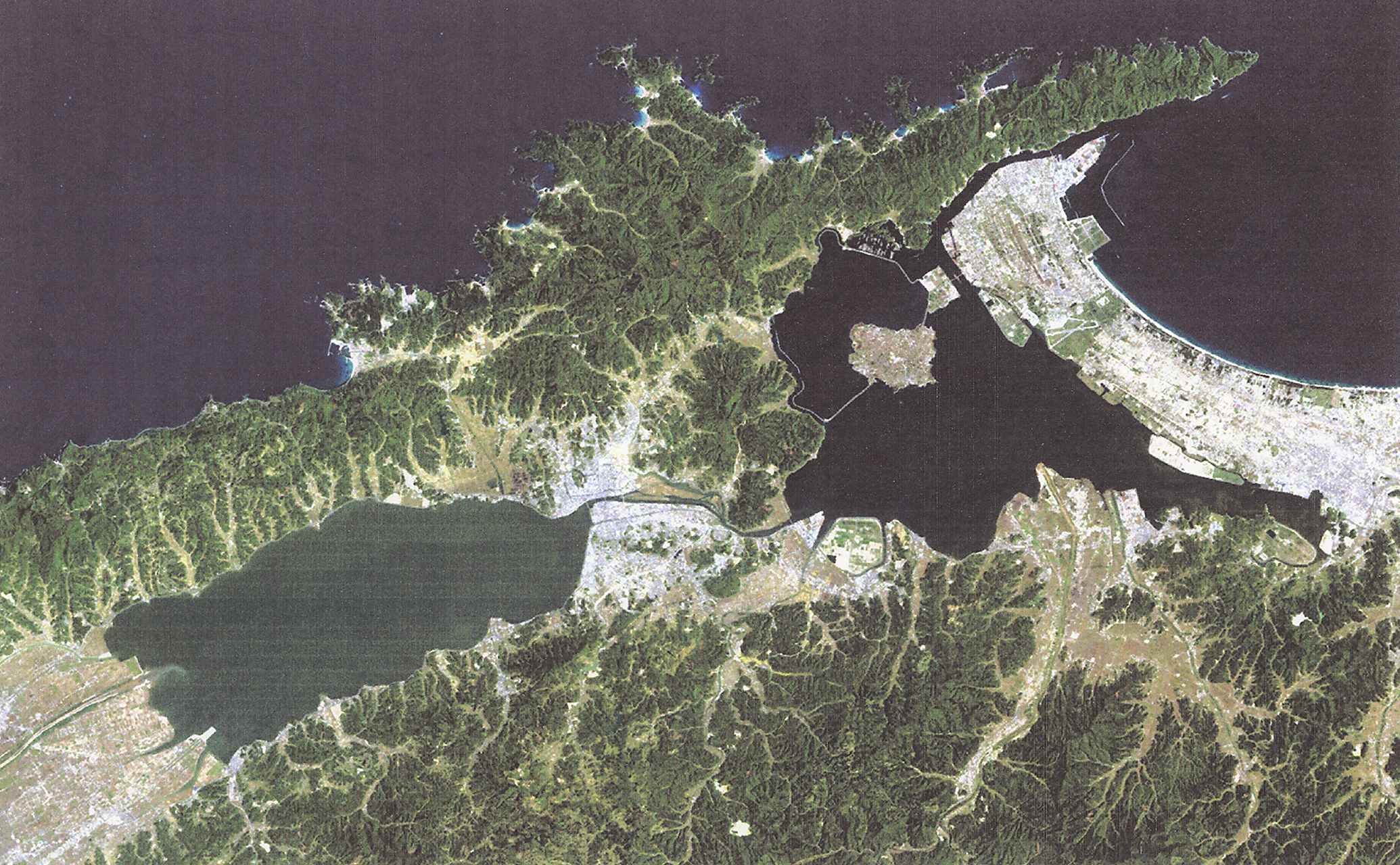
Lake Shinji and Lake nakaumi are coupled coastal lagoon lake systems in Japan, and these lakes have suffered detrimental efects by human activities, especially during the last 40 years, because of the big national projects aiming at desalination and reclamation of these lakes. In the year 2000, however, the land reclamation project in Lake Nakaumi was officially discontinued, leaving Honjou area unreclaimed. Shortly thereafter, desalination project was also terminated. This was the end of a large and expensive series of public works projects, and in 2005, these two lakes were included in the list of wetlands of international importance, and the efforts to restore the lakes are undergone.
-
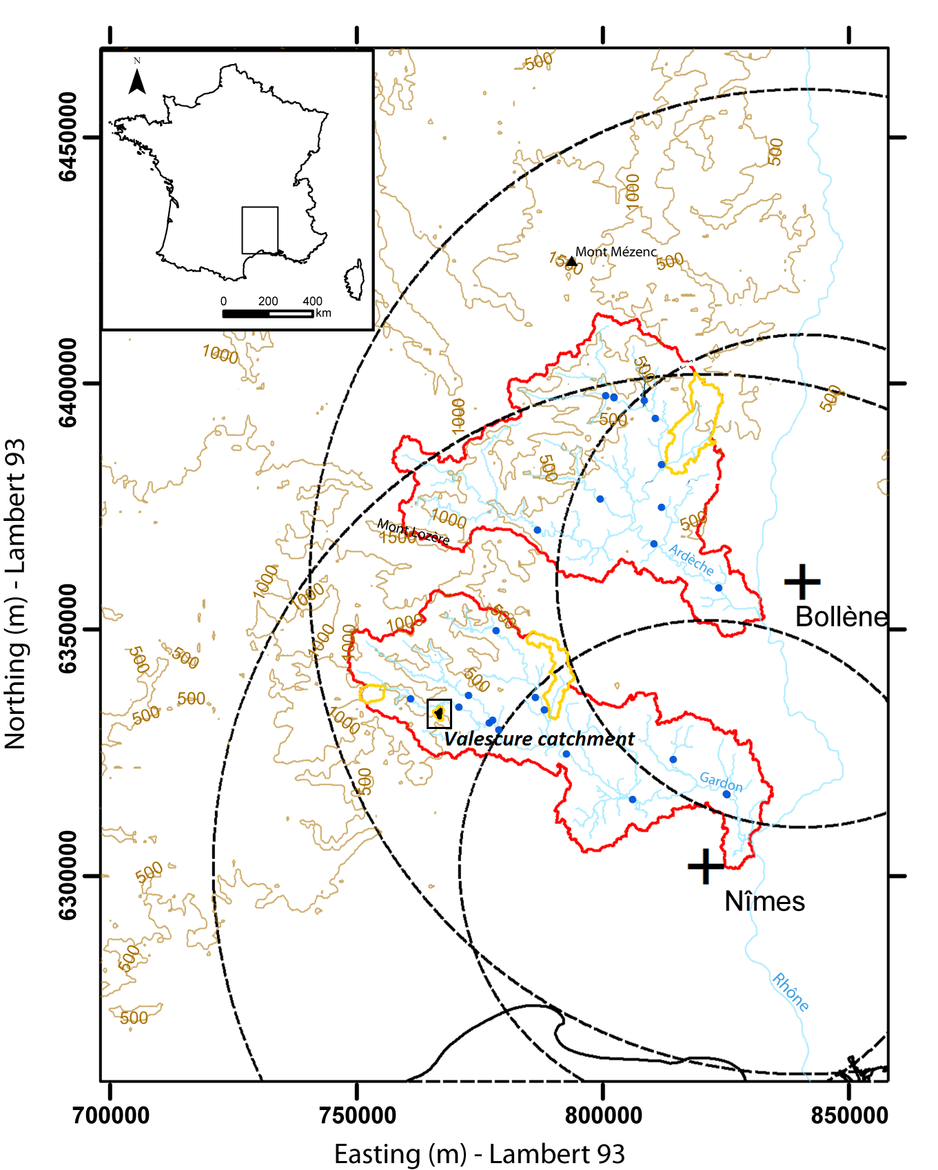
Hydrometeorological observations within 6 embedded catchments (from 0.3 to 3.9 km2). Mediterranean climate with heavy rainfall and flash floods in automn. The geology is mainly granite. The land use is mainly forest. This site is typical of the Cévennes region. More information at http://www.ohmcv.fr
-
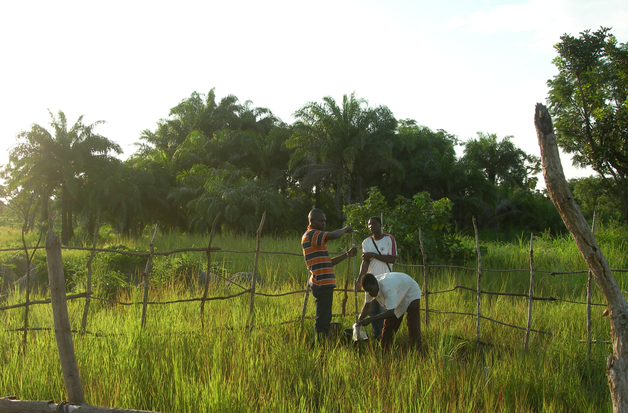
The Oueme mesoscale site (Benin) is part of the AMMA-CATCH observation network. Its characteristics are as follows a 14000 km² basin in sudanian climate on a crystaline basement. The studies focus on the hydrological cycle, the water budget and the hydrological processes.