
CNR - Institute of Ecosystem Study (ISE)
Type of resources
Available actions
Topics
Keywords
Contact for the resource
Provided by
Years
Formats
Representation types
-
This dataset includes Chlorophyll a concentration in μg/L. Measurements of Chl a were made on discrete water samples collected monthly in the upper 20 meters layer at sampling station Ghiffa (45°58’30’’N; 8°39’09’’E) from January 1984 to December 2018. Chl a measurements derived by spectrophotometric technique in the period from January 1984 to December 2009, while from January 2010 to December 2018 measurements derived from vertical profiling instrument (FluoroProbe).
-
The dataset contains monthly data of transparency measured as Secchi depth at the Ghiffa station (deepest point) during 1988-2018
-
Monthly bulk deposition of SO4, NO3, NH4, P-PO4, major cations (Ca, Mg, Na, K) in kg ha-1 at the sampling station of Pallanza, in Lake Maggiore watershed. Data are volume weighted monthly average values calculated from weekly data.
-
The dataset contains monthly data, volume weighted average values for epilimnion (0-25 m) and hypolimnion (25-360 m), for the period 1988-2018 and 2019-2021 for the following variables: water temperature, pH, conductivity, Ntot, NH4N, NO3N, Ptot, PO4P, cation and anion concentrations
-
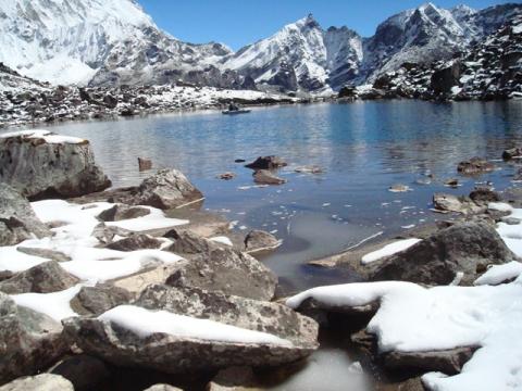
The site include two high altitude oligomictic lakes located in the Himalayas (Khumbu Valley, Mt. Everest). Those ecosystem lies at ca. 5000 m a.s.l. and have similar characteristic to other high altitude sites, e.g. Alpine lakes, but they are characterized by a tropical climate being under the influence of monsoon activity.
-

The lake is located in the Khumbu Valley, Sagarmatha National Park (SNP), Nepal. SNP is situated in the Solu-Khumbu district, in the north-eastern region of Nepal and represents the northernmost part of the Dudh Koshi River Basin, which is part of the Koshi River Basin (or SaptaKoshi Basin), one of the seven major hydrographic basins into which Nepal is subdivided. The SNP covers an area of 1141 km2 and is surrounded on all sides by the highest mountain ranges on Earth. The terrain is extremely irregular, with altitudes that reach 8848 m. The lower topographic limit of permanent snow cover is located at an altitude of 5500–5600 m. The climate of the SNP is driven by the Asian monsoon. The lake bedrock is mainly Late Tertiary Granites, with a primarily quartz–silicate composition and a low weathering rate. Soils are absent or very thin in most of the catchments. Vegetation cover is restricted to small areas of alpine meadow. The lake surface area is 0.009 km2. The lake lies above 5000 m a.s.l., the tree line limit. The lake is fed by a small glacier located in the catchment. The lake is ice-covered for ca. 9–10 months every year (from October–November to June–July). Chlorophyll a concentrations are below 1 lg l-1 and are probably controlled by strong grazing pressure from a large pigmented (keto-carotenoid of astaxanthin type) zooplankton community. Total phosphorus concentrations (mean values) are about 2 µg P l-1, whereas total nitrate concentrations are about 120 µg N l-1. Concentrations of particulate organic carbon (POC) and dissolved organic carbon (DOC) are very low.