
Ministry of Education, Youth and Sports of the Czech Republic
Type of resources
Available actions
Topics
Keywords
Contact for the resource
Provided by
Years
Formats
Representation types
-
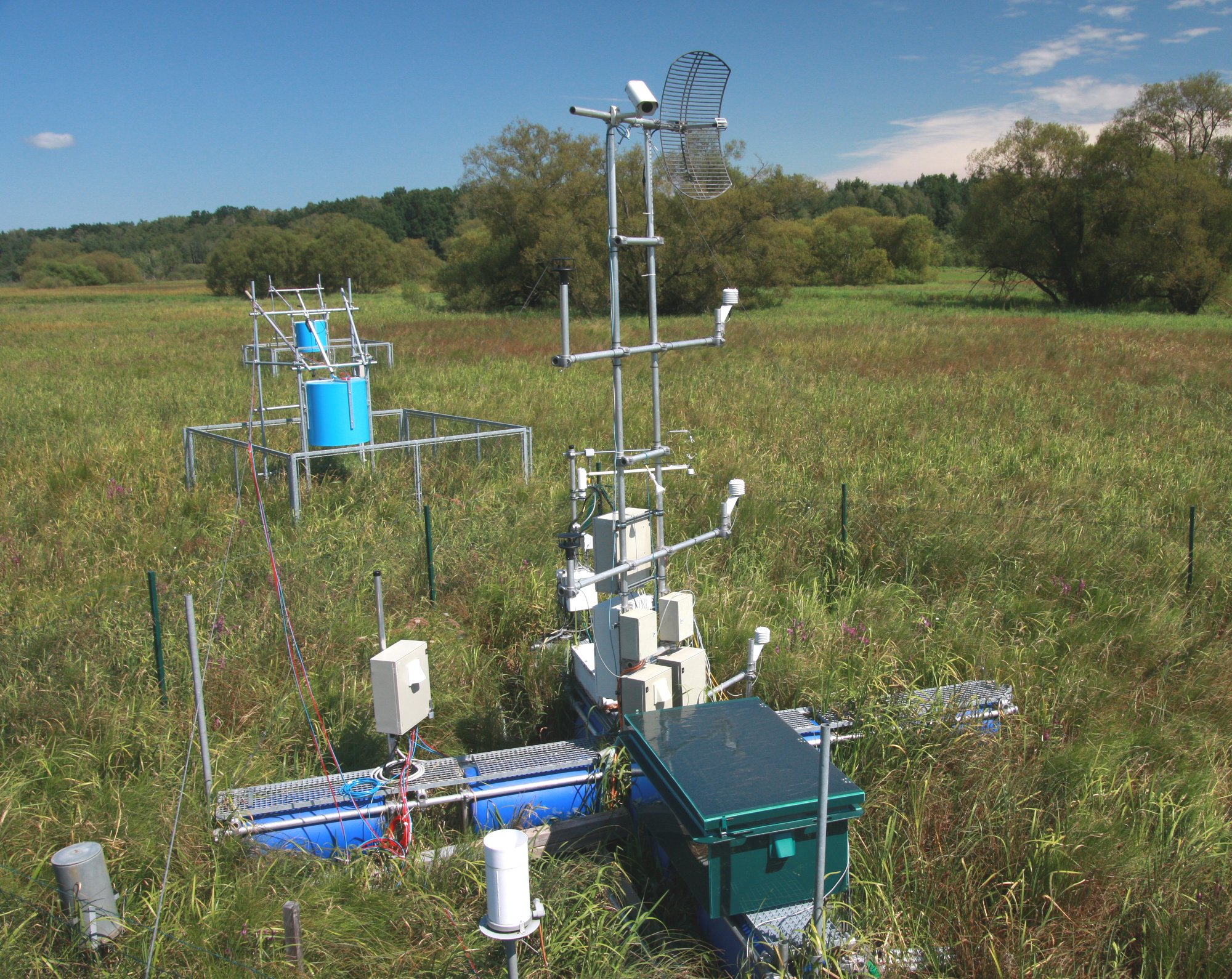
The Třeboň Wet Meadows is an LTER site of a 1 hectare area. It is a part of a wetland with the total area of 450 hectares situated in the inundation area of a large human-made reservoir (Rožmberk fishpond, 5 km2). The Wet Meadows are a predominantly herbaceous wetland with an up to several meters thick layer of organic sediment, which is superimposed on quaternary alluvial sands and clays. The vegetation cover is formed mainly by tall sedges (Carex acuta, C. vesicaria) and reed Canarygrass (Phalaris arundinacea). During the last 50 years, after cessation of mowing, a distinct stand structure of hummocks and hollows has developed. The hummocks are formed by tussocks of Carex acuta. On the site, wide water level fluctuations are recorded in some years. The relatively regular spring floods and irregular summer floods occur as a consequence of snow melting and summer rains in the catchment area, respectively. Extreme floods occurred in the summer of 2002 and both spring and summer of 2006, when the water level culminated at 2 m above the soil surface. The most frequently recorded position of the water level is at about −0.1 m. From 1977 to 2006, meteorological measurements were executed in a meteorological screen. Starting from 2006, the measurements have been executed with electronic sensors connected to data-loggers. Since that time, the site has been equipped for measuring carbon exchange and fluxes of CO2 and H2O (eddy covariance system, Licor). Since the spring of 2011, the site has been equipped for measuring methane and CO2 emissions from the sedges (automatic static flow chamber with a laser gas analyzer, LGR).The Wet Meadows are included in the integrated carbon observation system (ICOS) as a wetland ecosystem station.
-
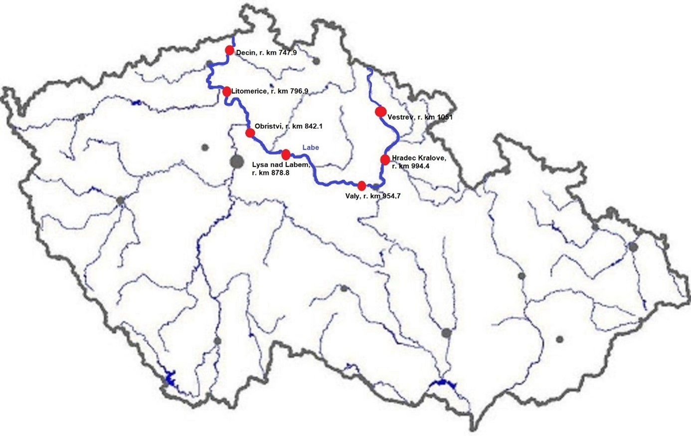
The Elbe River is one of the major rivers in Central Europe. It springs at an altitude of about 1,400 meters in the Giant Mountains in the north of the Czech Republic. It flows through eastern, middle, and northern Bohemia, and its catchment area includes most of Bohemia. The Elbe traverses the northeastern part of Germany and flows into the North Sea. The total river length is 1,094 km. In the Czech Republic, the monitored river length is 371 km and the catchment area includes 49,933 km2. The average flow at the Czech-German borders is 311 m3 s-1. Many weirs dam the watercourse of Elbe River in the Czech Republic. This artificial intervention is crucial for the characteristics of the riverbed, its width, depth, and bottom substrate. The width of the riverbed in the monitored area ranges from approx. 10 m on the upper course to approx. 150 m on the lower course and river sections above the weirs. The depth of the river varies from 0.5 m in the upper parts and below the weirs to more than 5 m in the lower course and above the weirs. The bottom substrate varies from the stony, gravelly, and sandy fractions in shallow and fast-running sections to muddy/silty fractions in slow-running sections above the weirs. The main tributaries of the Elbe in Bohemia are Metuje, Orlice, Jizera, Ploučnice, Vltava, Ohře and Bílina rivers. The catchment area is densely populated. The river is exposed to various sources of pollution (organic, agricultural, and industrial) and hydromorphological pressures (straightening, shortening, regulation of meanders, and fragmentation of river continuity). There are seven permanent monitoring sites on the Elbe River in the Czech Republic: Děčín (river kilometer 747.9), Litoměřice (796.9), Obříství (842.1), Lysá nad Labem (878.8), Valy (954.7), Hradec Králové (994.4) and Vestřev (1051). The Elbe basin long term environmental research has been organised by the Ministry of Environment of the Czech Republic and cooperation institutions since 1993. More than 600 physicochemical parameters, including sensory properties of water, are regularly monitored in at least nine different types of matrices (water, sediment, periphyton, floats, sedimentable floats, benthos, fish tissues, fish fry, and Dreissena polymorpha tissue) and using passive samplers. Among the main monitored characteristics belong balances of macroelements (carbon, nitrogen, oxygen, phosphorus), concentrations of inorganic salts, heavy metals and various organic pollutants such as pesticides, personal care products (including drugs) and other anthropogenic substances in the environment. Characteristics such as abundance and species composition are regularly monitored in fish, macrophytes, macrozoobenthos, phytobenthos and plankton.