
Observatoire des Sciences de l'Univers de Grenoble (OSUG)
Type of resources
Available actions
Topics
Keywords
Contact for the resource
Provided by
Years
Formats
Representation types
-
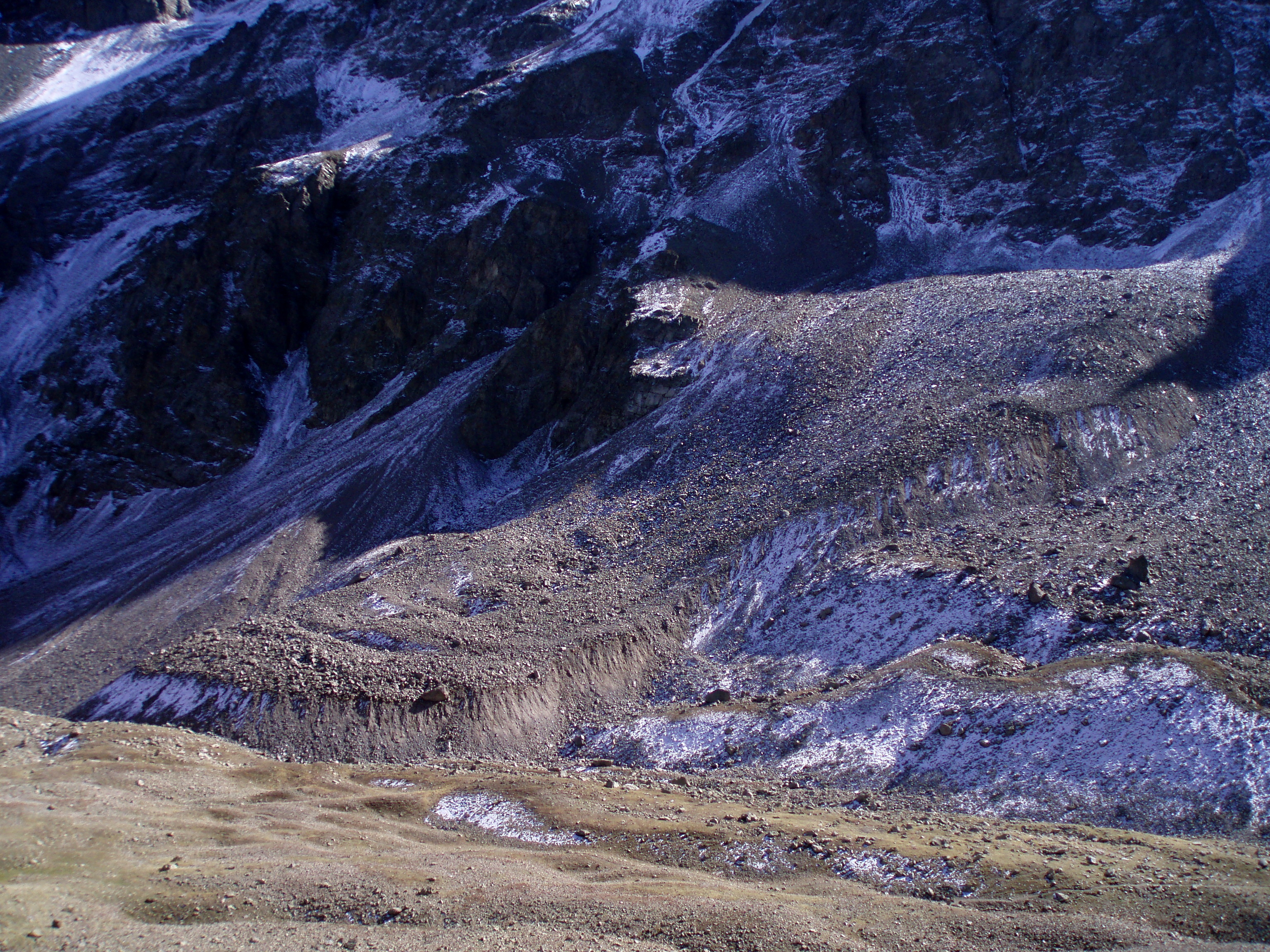
An active rock glacier in the French Alps, at the climatic boundary between Mediterranean and Oceanic climatic zones, near the Col du Lautaret (45°N). Located between 2650 and 2450 m asl, this ice-rich permafrost landforms, typical of high mountain periglacial environments, is studied since the late 70' and has the longest series of monitoring. Its displacements are measured using geodetic methods (total station, GPS, terrestrial LiDAR and photogrammetry). Monitoring of the Laurichard rock glacier aims at understanding the responses of mountain permafrost to Climate and Global change.
-
The Derochoir rockglacier is situated above the village of Les Houches, in the western part of the Mont Blanc massif (France). It is one the very few rockglaciers in the Mont Banc massif. It is a small rockglacier with a suspended front, overhanging the torrential catchment of the Arandellys torrent, which flows through the village of Les Houches and eventually caused flooding of parts of the village.
-
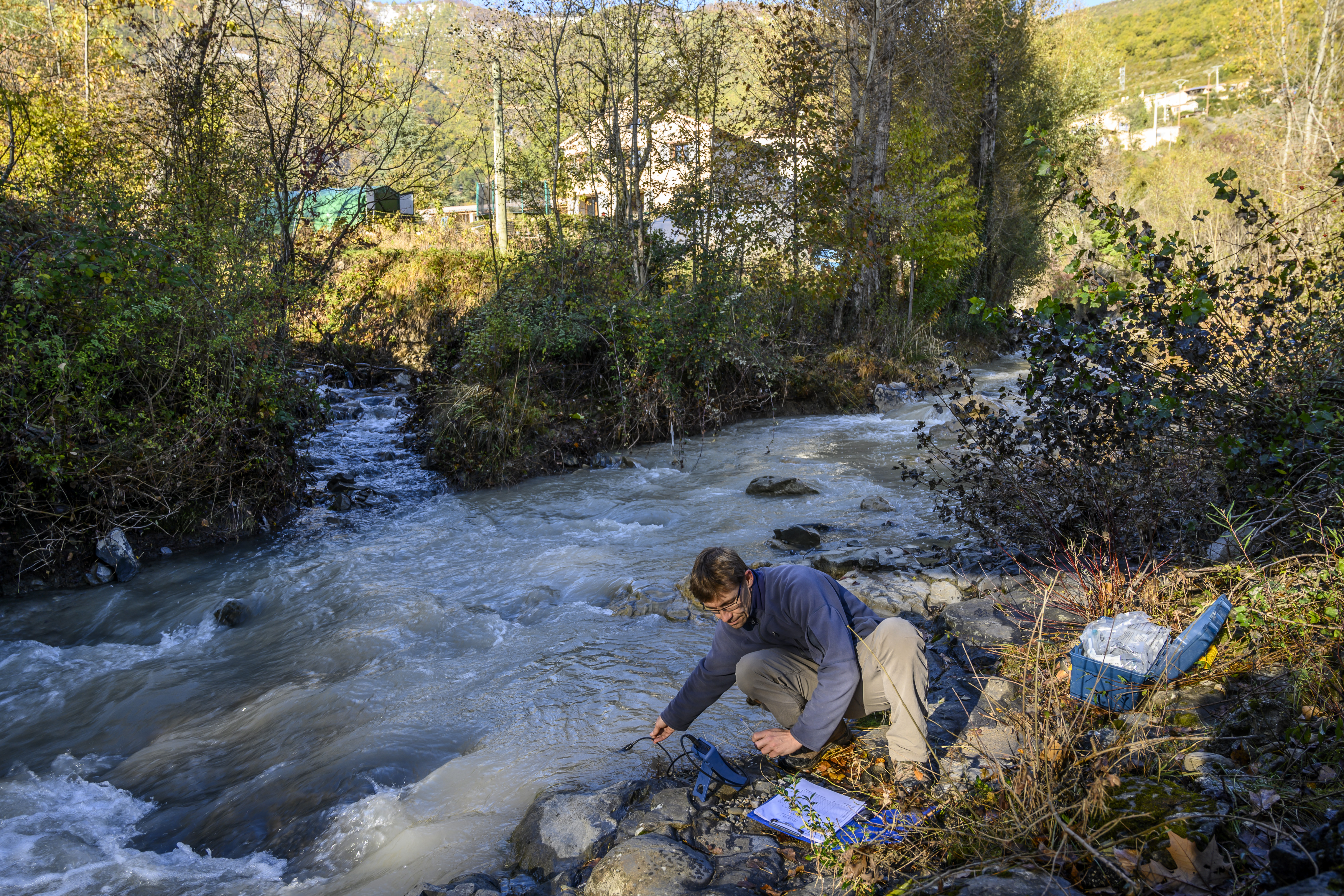
The Galabre site is part of Draix-Bleone observatory, located in the French South Alps, upstream of Digne, on the right side of the Bleone river. The hydrosedimentary station of La Robine-sur-Galabre was created in 2008 to measure water of sediment fluxes from the Galabre catchment, 20 km2. This catchment integrates a diversity of lithologies and land use that are characteristic of the Pre-Alps. The climate is mountainous and Mediterranean. The site is characterized by intense erosion and intermittent sediment fluxes. The variables that are monitored on the long-term include rainfall and meteorology, high-frequency water discharge and suspended sediment concentration (10 minutes), some physico-chemical properties of stream water and sediments.
-
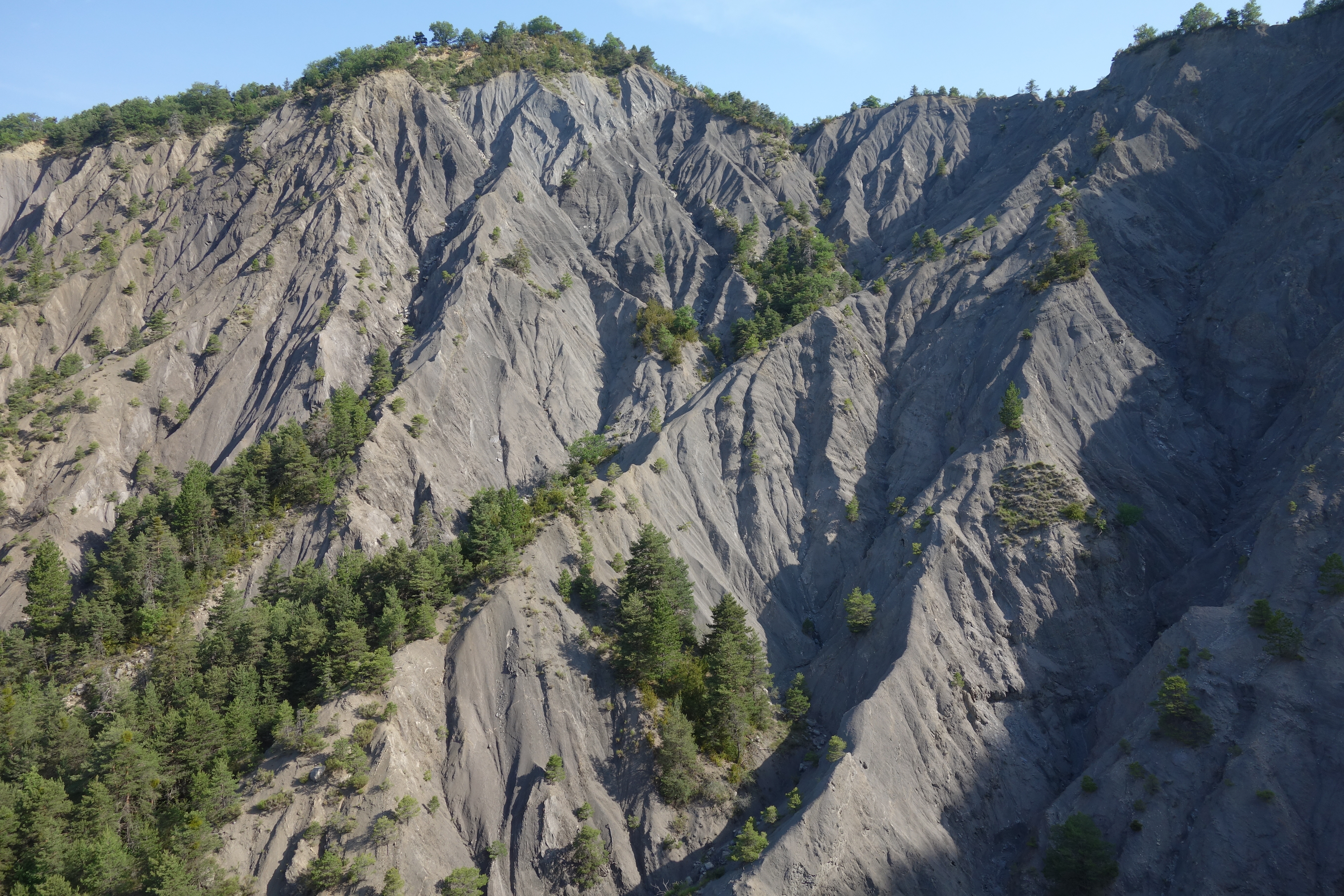
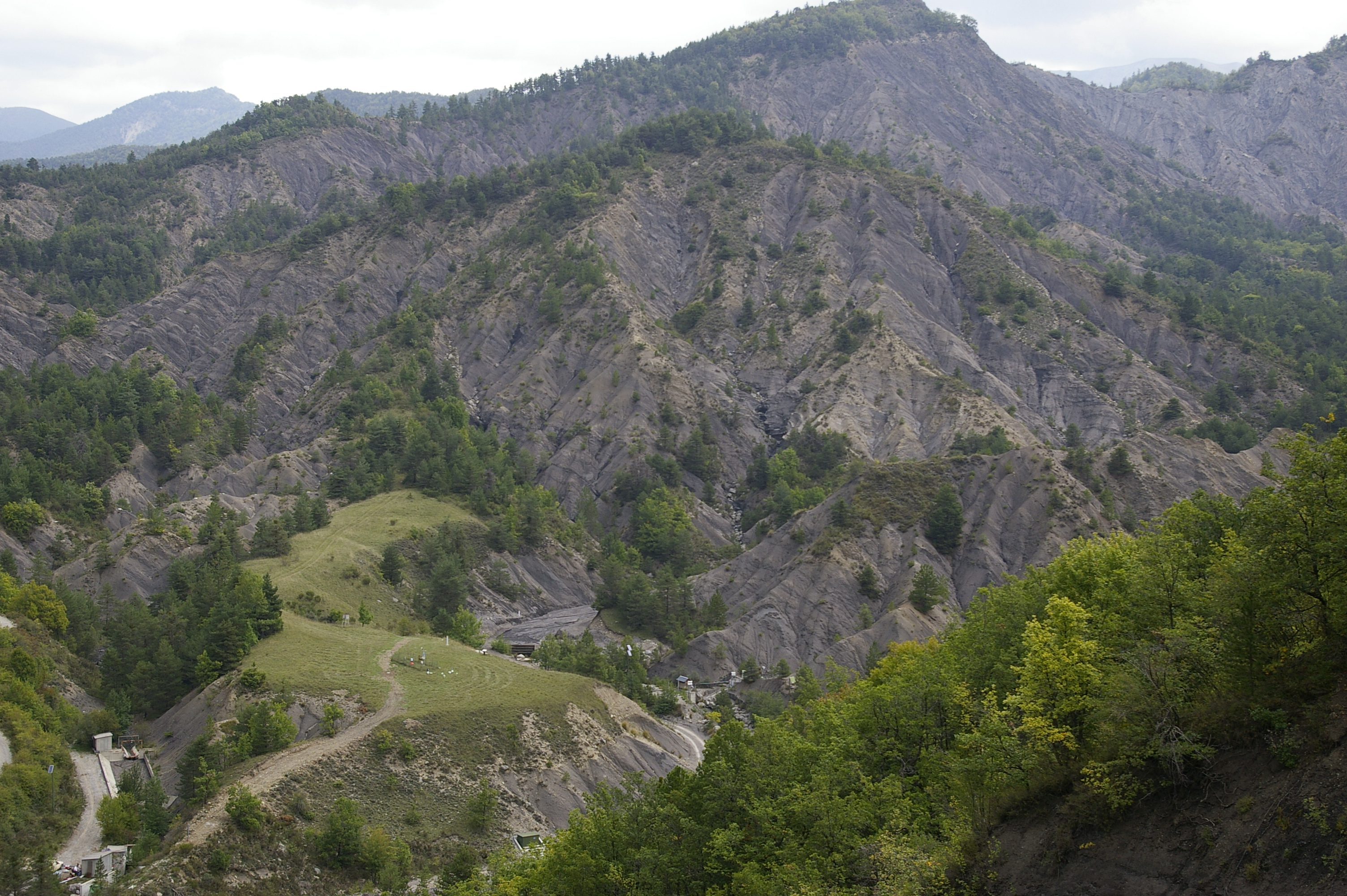
Draix site is part of Draix-Bleone observatory, located in the French South Alps, upstream of Digne, on the left side of the Bleone. Draix site was equipped in 1983 to study mountain erosion and sediment transport. It is composed of 4 catchments, which are equipped to measure water and sediment fluxes, at spatial scales ranging from 0.001 km2 to 1 km2, with contrasted land cover. These catchments are entirely situated on black marls that are very sensitive to weathering and erosion, resulting into a badland topography. One catchment was reforested at the end of the XIXth century whereas the other are mostly denuded. This site is characterized by intense erosion and intermittent sediment fluxes. The variables that are monitored on the long-term include rainfall and meteorology, high-frequency water discharge and suspended sediment concentration (1-10 minutes), event-scale bedload transport, and some physico-chemical properties of stream water and sediments.
-
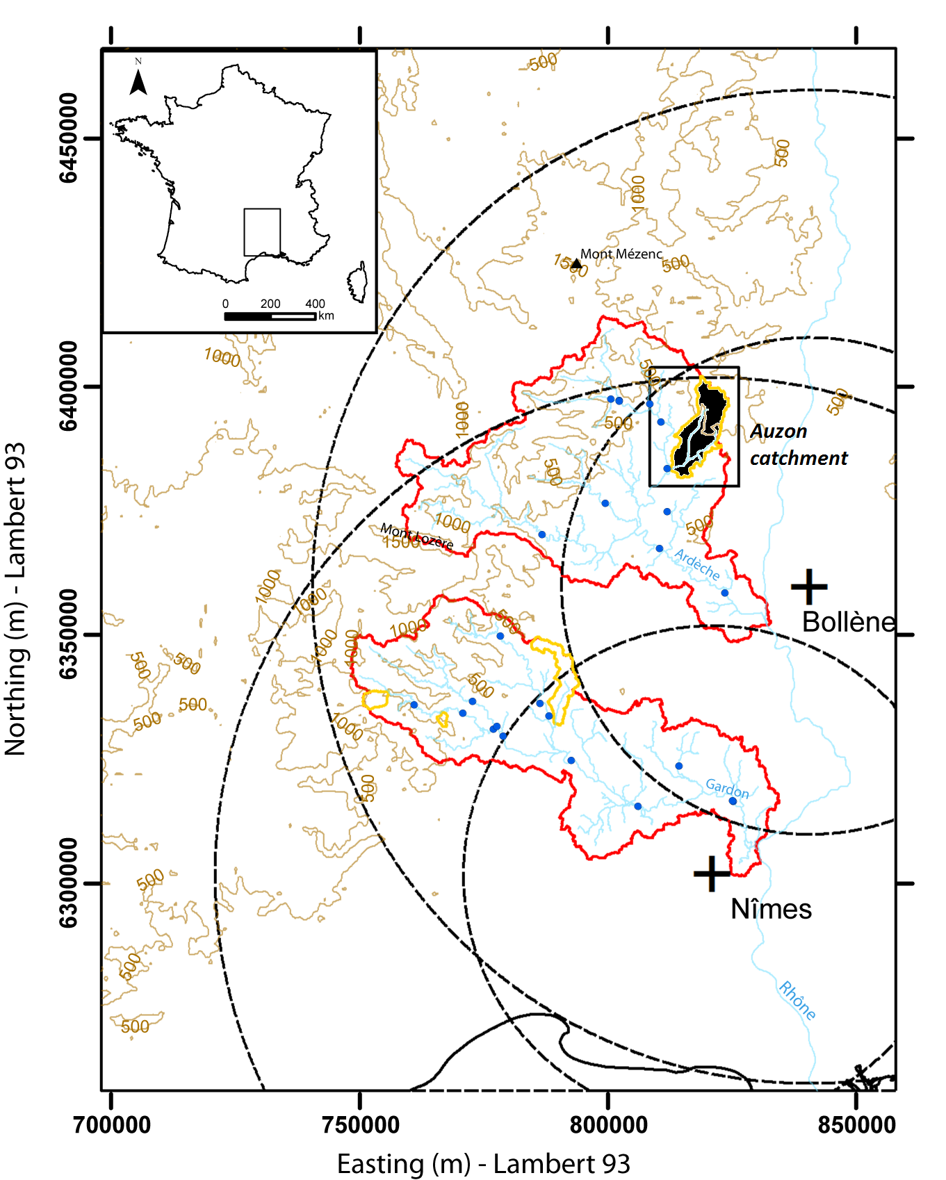
Hydrometeorological and hydrosedimentary observations within 3 embedded catchments: Gazel, Claduègne and Auzon (3.4, 43, and 116 km²). Mediterranean climate with heavy rainfall and flash floods in automn. The upper part of the catchment is characterized by basalt formations, after which a sharp transition occurs where the lower two thirds is made up of sedimentary limestone rock. The soil types are heavily infuenced by the geology of the catchment. Main land use types are pastures,vineyards and forest. More information at http://mistrals.sedoo.fr/?editDatsId=1438
-
Draix-Bleone observatory was created in 1983 to study mountain erosion and sediment transport. It is located in the French South Alps, upstream of Digne, on the left side (Draix site) and right side (Galabre site) of the Bleone river. Several catchments are equipped to measure water and sediment fluxes, at spatial scales ranging from 0.001 km2 to 34 km2, with contrasted land use and land cover. The smallest catchments are entirely situated on black marl that are very sensitive to weathering and erosion, resulting in a badland topography. The Bouinenc and Galabre catchments integrate a larger diversity of lithologies and land use that are characteristic of the Pre-Alps. The climate is mountainous and Mediterranean. These sites are characterized by their intense erosion and intermittent sediment fluxes. The variables that are monitored on the long-term include rainfall and meteorology, high-frequency water discharge and suspended sediment concentration (1-10 minutes), event-scale bedload transport, some physico-chemical properties of stream water and sediments. Draix-Bleone Observatory is managed by IGE and is funded by INRAE, INSU and OSUG. It is a member of the French research infrastructure OZCAR. The GIS Draix-Bleone gathers all research teams involved on these sites.