
TERN Ecosystem Processes Network
Type of resources
Available actions
Topics
Keywords
Contact for the resource
Provided by
Years
Formats
Representation types
-
The Boyagin Wandoo Woodland SuperSite was established in September 2017 by the University of Western Australia. Located in the Boyagin Nature Reserve, approximately 12 km west of Pingelly, Western Australia the SuperSite monitoring activities complement the Avon River Catchment Critical Zone Observatory at the UWA Future Farm in Pingelly that focusses on managed landscapes (rotational dryland wheat cropping and grazing pastures for sheep). The climate is Semi-arid (Dry) Warm Mediterranean. The Boyagin SuperSite is collocated with the Land Ecosystem Atmosphere Program (LEAP) - Boyagin. Boyagin SuperSite is located in the Avon Wheatbelt (AW2-Re-juvenated Drainage subregion) and has a high density of rare and geographically restricted flora and supports populations of several marsupials subject to fox predation (Numbat, Quenda, Woylie, Tammar, Red-tailed Phascogale, Brushtail Possum) that have disappeared from most of the Australian or Western Australian mainland. The Noongar people are the traditional owners at Boyagin.
-
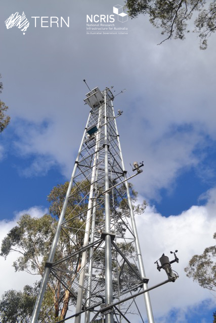
Warra Tall Eucalypt SuperSite is a member of the Australian SuperSite Network (SuperSites, http://www.supersites.net.au/), a facility within the Australian Terrestrial Ecosystem Network (TERN, http://www.tern.org.au/). SuperSites aims to answer both network wide and site-specific science questions through long term monitoring using both sensor technology and classical field methods. The Warra Tall Eucalypt SuperSite is located in southern Tasmania, where tall, wet Eucalyptus obliqua forests predominate, and are part of the cool, temperate wet forest biome. These forests are among the most productive terrestrial ecosystems in the world and their management generates a disproportionately high social and political interest. The site also includes some areas of moorland, temperate rainforest, riparian and montane conifer forest and scrubs. Warra is partly within the Tasmanian Wilderness World Heritage Area, which is managed for conservation, and partly within State forest, which is managed for multiple purposes including wood production. Warra Tall Eucalypt was established as a Long-term Ecological Research (LTER) site in 1995, and is one of Australia’s most scientifically productive. It is a hub for intensive, multi-disciplinary research to understand the fundamental ecological processes in E. obliqua forests and the long-term effects that management has on those processes in contrast with natural disturbance. Current research is focussing on the bio-physical processes that support the biota and how they fluctuate across scales both spatial and temporal. Detailed knowledge exists for many elements of the biota at Warra Tall Eucalypt their habitats, their distribution and their response to disturbance. Importantly, research done at Warra Tall Eucalypt has directly driven improvements in forest management more generally, e.g. the introduction of variable retention silviculture in mature tall, wet eucalypt forests. Key research objectives - What are the fundamental ecological processes in E. obliqua wet forests? - What are the current biodiversity and geodiversity of the site and how are these changing, evolving and interacting? - What are the long-term effects of different forest management and fire regimes on biodiversity, geodiversity and ecological processes? - What are the flows of water, nutrients and energy, the biota through which those flows occur, and how do they assemble, interact, and change over time? - How do disturbances, both natural and human-induced alter the biological, physical and geochemical properties of the ecosystem? In particular, what are the mechanisms through which the ecosystem recovers following disturbance, what are the feedbacks that determine or alter those responses, and what are the thresholds beyond which state changes occur? TERN acknowledges the palawa and pakana people (Tasmanian Aboriginal community) as Traditional Owners of lutruwita (Tasmania).
-
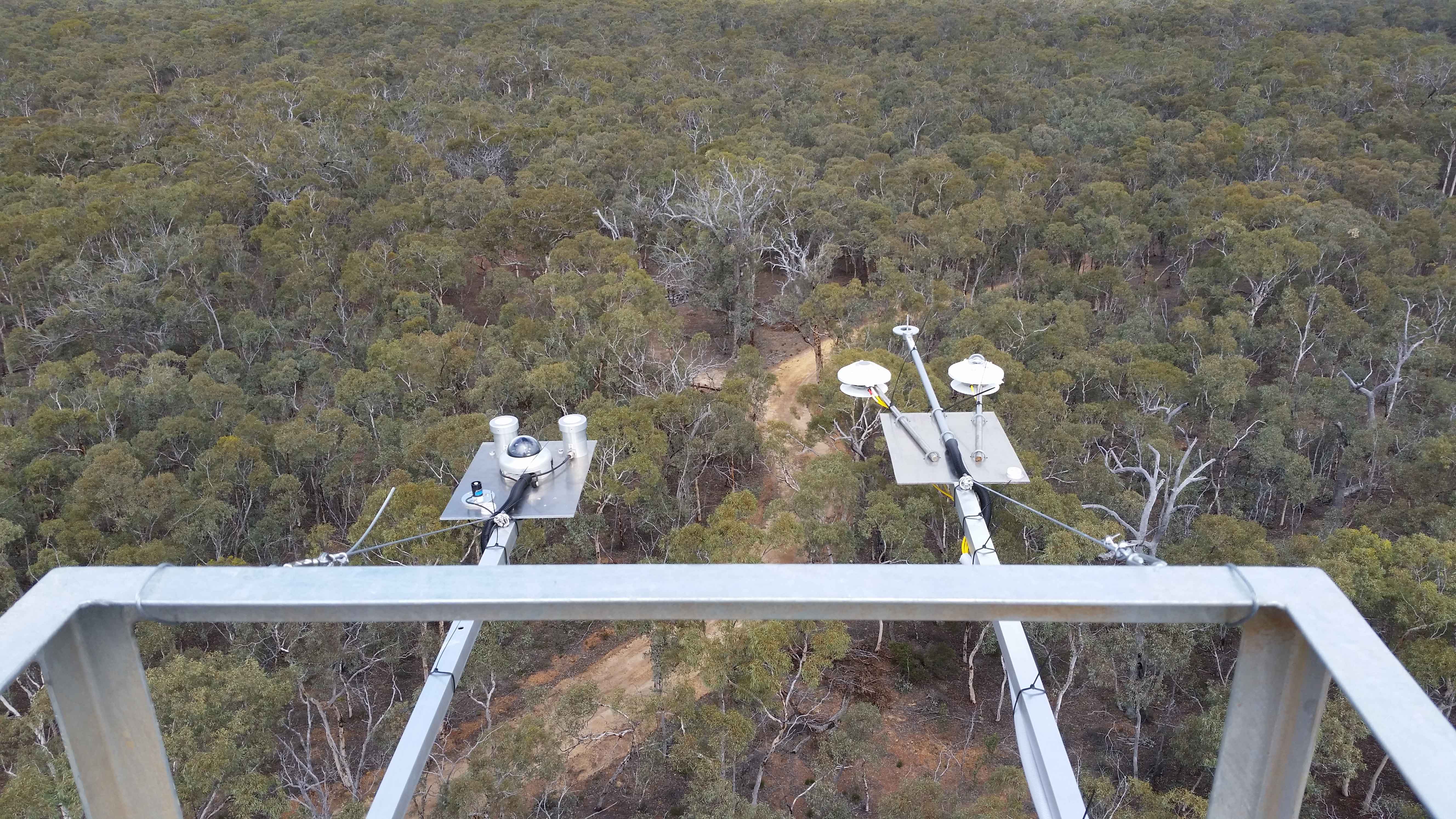
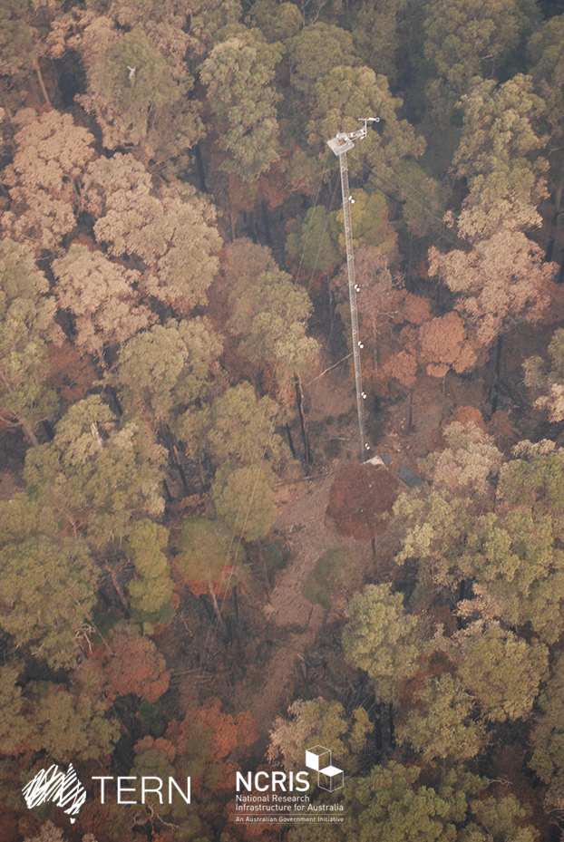
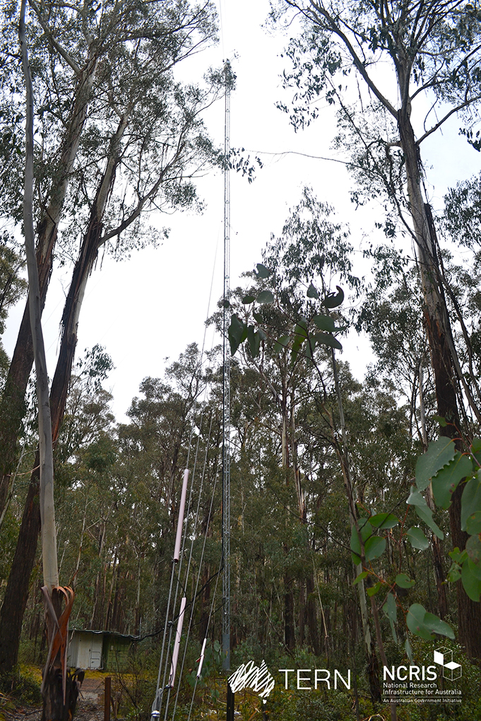
The Wombat Stringybark Eucalypt SuperSite is a member of the TERN Ecosystem Processes platform (https://www.tern.org.au/tern-observatory/tern-ecosystem-processes/), a field observatory within the Australian Terrestrial Ecosystem Network (TERN, http://www.tern.org.au/). The Wombat Stringybark Eucalypt SuperSite is located in the Wombat State Forest, Victoria, South Eastern Australia at an elevation of 713m. The site is a secondary re-growth forest that was last harvested in 1980. Dominant tree species are Eucalyptus obliqua (messmate stringybark), Eucalyptus radiata (narrow leaf peppermint) and Eucalyptus rubida (candlebark) with an average canopy height of 25 m. The understorey consists mainly of patchy grasses and the soil is a silty-clay overlying clay. The forest is managed by the Department of Environment, Land, Water and Planning and management includes selective harvesting and prescribed burning regimes. The climate of the study area is classified as cool-temperate to Mediterranean zone with cold and wet winters (May-Aug) and warm and dry summers (Dec-Feb). Key research objectives include: • What are the elements of structure, composition, functions and processes of the dry eucalypt forests of South Eastern Australia required for the sustainable management of these ecosystems? • What is the carbon sink/source strength of a dry sclerophyll forest and what is their contribution to Australia’s National Carbon Inventory? • What is the magnitude of emission and/or uptake of non-CO2 greenhouse gases, such as nitrous oxide and methane of dry eucalypt forest? • How will climate variability, drought or fire influence the ecosystem processes of dry eucalypt forest? The Dja Dja Wurrung peoples are the traditional owners at Wombat.
-
The Victorian Dry Eucalypt SuperSite is a member of the Australian SuperSite Network (SuperSites, http://www.supersites.net.au/), a facility within the Australian Terrestrial Ecosystem Network (TERN, http://www.tern.org.au/) and has two nodes (Whroo and Wombat). The Victorian Dry Eucalypt SuperSite - Whroo site near Shepparton was established in 2011. The vegetation is dominated by two main Eucalypt species: Eucalyptus microcarpa (Grey Box) and Eucalyptus leucoxylon (Yellow Gum). Smaller numbers of Eucalyptus sideroxylon (Ironbark) and Acacia pycnantha (Golden Wattle) are also found on site. The surrounding area includes the Whroo Historical area, and Rushworth State containing remnant native vegetation. Key research objectives include: • What are the elements of structure, composition, functions and processes of the dry eucalypt forests of South Eastern Australia required for the sustainable management of these ecosystems? • What is the carbon sink/source strength of a dry sclerophyll forest and what is their contribution to Australia’s National Carbon Inventory? • What is the magnitude of emission and/or uptake of non-CO2 greenhouse gases, such as nitrous oxide and methane of dry eucalypt forest? • How will climate variability, drought or fire influence the ecosystem processes of dry eucalypt forest? . The site is on the lands of the Ngurai-illam-wurrung Aboriginal people.
-

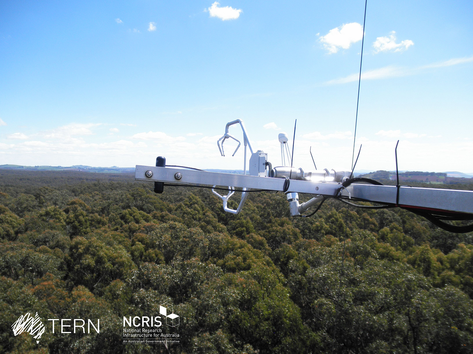
The Great Western Woodlands SuperSite is a member of the Australian SuperSite Network (SuperSites, http://www.supersites.net.au/), a facility within the Australian Terrestrial Ecosystem Network (TERN, http://www.tern.org.au/). The GWW Supersite comprises a mosaic of temperate woodland, heathland and Mallee vegetation within the Great Western Woodlands (GWW) in south-western Western Australia. The core plots are located on the proposed Credo Conservation Reserve, a former pastoral lease that was established in 1906–07 where it first carried sheep and later cattle. In 2007 the lease was sold to the government and managed by the Western Australian Department of Parks and Wildlife who are collaborators on a range of projects. Native title claims of traditional ownership at this site have been registered by the Marlinyu Ghoorlie and Maduwongga Peoples. Key research objectives include: What are the impacts of climate change and management on the fundamental flows of energy, carbon, water and nutrient stocks in semi-arid woodland ecosystems. • Are old-growth semi-arid woodlands carbon sources or carbon sinks? • Are fire regimes changing in the GWW? • How do GWW biodiversity and fire fuels change with time since fire and what are the implications for fire management? • How do GWW woodlands and shrublands persist at low rainfall? What are the ecological determinants of the Menzies line (the striking boundary between the GWW and mulga) and how does it inform management for climate adaptation? • How will GWW biodiversity be affected by climate change? Will the response of fauna depend predominantly depend on vegetation responses? • How will regional versus population-scale genetic variability in key traits such as water use efficiency contribute to climate adaptation? • What are the thresholds of woodland persistence with respect to fire and rainfall? • What exotic species are invading the GWW, and which are the greatest threat under climate change?
-
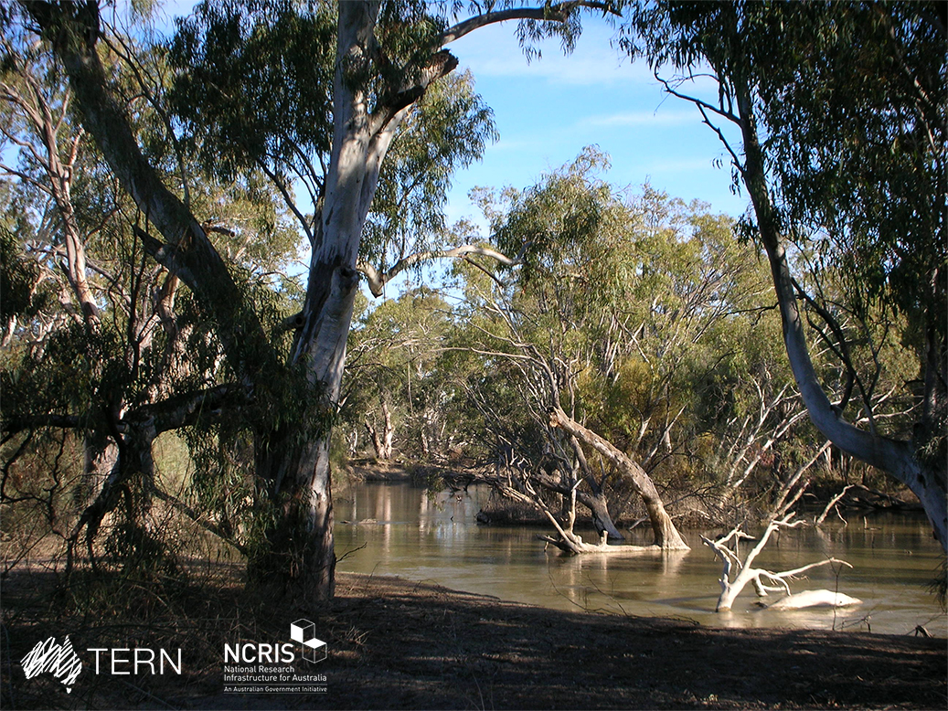
The Calperum Mallee SuperSite is a member of the Australian SuperSite Network (SuperSites, http://www.supersites.net.au/), a facility within the Australian Terrestrial Ecosystem Network (TERN, http://www.tern.org.au/). The SuperSite is located on Calperum Station, near Renmark, South Australia with research plots located in mallee woodland, Callitris woodland and floodplain black box, river red gum and lignum ecosystems. The property was a pastoral grazing lease for nearly 150 years, so it has suffered grazing-induced modifications to its ecosystems that are now being actively restored. The Native Title for the area is held by the First Peoples of the River Murray and Mallee. Key research objectives include: • What are the fundamental energy, carbon, water and nutrient stocks and flows in the Mallee, Callitris woodland and river floodplain ecosystems? • How are these stocks and flows responding to the management interventions (reduced and controlled grazing, controlled fire, controlled floods on the floodplain)? • How are the biota changing in form, frequency and distribution as climate changes and management interventions are imposed? • How important is the connectivity between these ecosystems for hydrology, faunal movement and as refugia in times of drought?
-
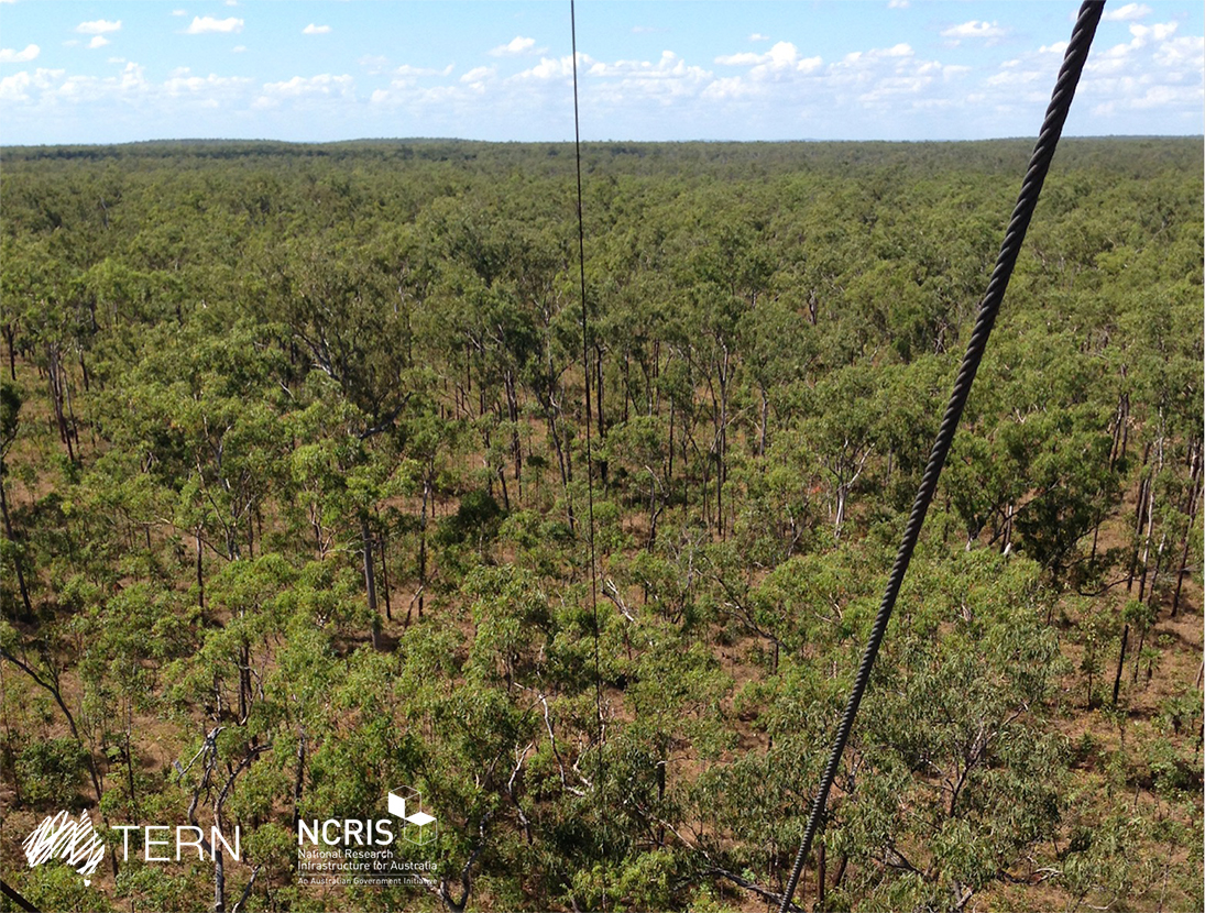
The Litchfield Savanna SuperSite is a member of the Australian SuperSite Network (SuperSites, http://www.supersites.net.au/), a facility within the Australian Terrestrial Ecosystem Network (TERN, http://www.tern.org.au/). The Litchfield Savanna SuperSite represents high rainfall, frequently burnt, tropical savanna. At 1.9 million km2, tropical savanna is the dominant ecosystem type across northern Australia. Understanding biogeochemical cycles, impacts of fire on sequestration, vegetation and fauna is a national priority. The site is a 5 km x 5 km block of relatively uniform open-forest savanna inside the park, and about 80 km south of Darwin. The infrastructure will help scientists understand the dynamics of vegetation structure and floristics by linking field observations with infrastructure measuring fluxes of carbon, water and energy. The fluxes will be linked to remotely sensed observations of vegetation cover and leaf area taken from the ground, aircraft and space. Key research objectives include: • What are the impacts of prevailing fire regimes (primarily frequency, but also intensity, extent, heterogeneity) on vegetation structure and composition, habitat quality, fragmentation and vertebrate faunal biodiversity? • How does vegetation structure, climate drivers and fire regime influence savanna carbon sequestration rate? • How can fire management contribute to greenhouse gas abatement and carbon sequestration in savanna ecosystems? • What are the impacts of climate change on fire regimes and subsequent feedbacks to savanna carbon and water cycles? Litchfield National Park encompasses the traditional boundaries of 4 Aboriginal language groups: Werat, Koongurrukun, Waray and Mak Mak Marranunggu
-
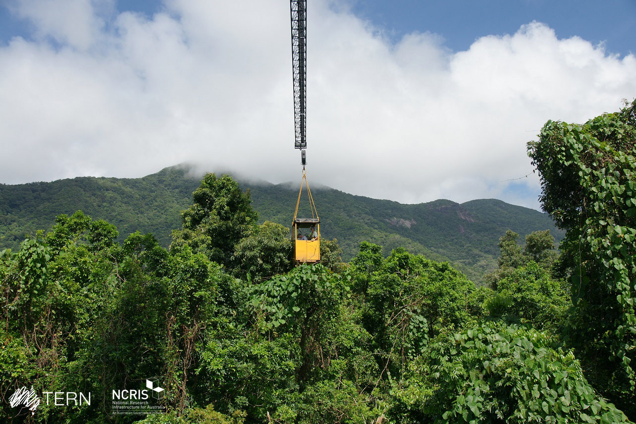
FNQ Rainforest SuperSite-Daintree is a member of the Australian SuperSite Network (SuperSites, http://www.supersites.net.au/), a facility within the Australian Terrestrial Ecosystem Network (TERN, http://www.tern.org.au/). SuperSites aims to answer both network wide and site-specific science questions through long term monitoring using both sensor technology and classical field methods. The FNQ Rainforest SuperSite is divided structurally into two transects, each based around an intensive study site node: the lowland rainforest node is based in the Daintree rainforest near Cape Tribulation and the upland rainforest is based at Robson Creek. The rainforests of FNQ occupy less than 0.2% of Australia’s landmass, yet support more than 10% of its flora, 36% of its mammals and 48% of its birds. The last remnants of the rainforests which formerly covered most of the continent, these globally significant World Heritage communities are also a repository for many ancestral lineages of the iconic species of Australia today, including kangaroos and eucalypts. Significant environmental clines (altitude, temperature, rainfall) exist over short distances in the region. This enables the monitoring of multiple parameters across a broad range of environments possible within the compact footprint of the FNQ Rainforest SuperSite. The Daintree node comprises two sites (i) the Daintree Rainforest Observatory (DRO) at Cape Tribulation, comprising a long-term monitoring plots, canopy crane, and extensive researcher and teaching infrastructure and (ii) research facilities at the Daintree Discovery Centre at Cow Bay, an award winning ecotourism interpretive centre featuring a canopy tower, aerial walkway and scientific monitoring. Key research objectives include: ● How are the biota (in particular locally endemic species) changing in form, frequency and distribution and what are the drivers for this? ● Does the vegetation represent a stable structure (overstorey versus understory dynamics) or has climate change affected it? ● Which taxa of organisms are the most sensitive to local climate change and how can these be assembled into an accurate biodiversity monitoring tool? ● What are the fundamental vertical and lateral energy, carbon, water and nutrient stocks and flows in the tropical forests of north Queensland? ● How are these stocks and flows responding to past management and climate change and how are they likely to respond in the future? ● How important is the connectivity between these ecosystems
-
The Tumbarumba Wet Eucalypt SuperSite is a member of the Australian SuperSite Network (SuperSites, http://www.supersites.net.au/), a facility within the Australian Terrestrial Ecosystem Network (TERN, http://www.tern.org.au/). The Tumbarumba Wet Eucalypt SuperSite is located in the Bago State Forest in New South Wales on the western edge of the Snowy Mountains. Key research objectives include: • How does airflow, terrain and forest structure affect the way the ecosystem takes up and releases carbon and uses water? • How can measures of carbon pools, stocks and turnover rates, atmospheric fluxes, be used to improve the surface–vegetation–atmospheric–transfer (SVAT) models? • What effects does vegetation have on the lower atmosphere, including the exchange of heat and the production of particles and chemical species that contribute to the formation of aerosols? We acknowledge and honour all traditional owners past and present of this area, including the Wiradjuri and Ngarigo people, who lived and continue to live on this land.
-
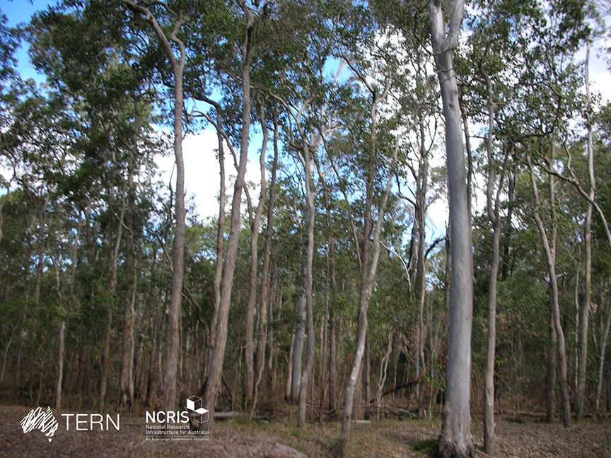
The South East Queensland Peri-urban SuperSite is a member of the Australian SuperSite Network (SuperSites, http://www.supersites.net.au/), a facility within the Australian Terrestrial Ecosystem Network (TERN, http://www.tern.org.au/). The SEQ Peri-urban Supersite’s (SEQP) core infrastructure is located at the sub-tropical 50 ha Samford Ecological Research Facility (SERF) of the Queensland University of Technology in Brisbane (https://www.qut.edu.au/research/why-qut/infrastructure/samford-ecological-research-facility). SERF is located at the western extent of the Pine longitudinal transect north of Brisbane where the urban footprint is rapidly expanding. The transect extends from the upper reaches of the Pine River catchment through the Samford Valley to Central Moreton Bay. The traditional custodians of the Samford Valley are the Yugara nation. Clan relations may well have extended into and from the neighbouring Jinibara and Kabi Kabi. The Supersite focuses on the impact of urban development and low frequency, high flow (ephemeral) events on terrestrial biogeochemistry, biodiversity and downstream water quality. Rapid population growth in SEQ is expected to continue particularly in peri-urban areas. The development, transformation of land use and exploitation of resources associated with this population growth will intensify the pressure on catchment, aquatic and coastal environments, potentially leading to significant habitat fragmentation, water quality issues, biodiversity loss and loss of economic and amenity values. The vulnerability of SEQ’s high biodiversity ecosystems will be compounded by climate change in the region. Key research questions: • Can ecosystem services be maintained in an urbanising environment? • How do carbon and energy balances change under different land uses in transition from a natural dry sclerophyll forest to a peri-urban area? • What impact will Brisbane’s peri-urban development have on water quality and soil borne greenhouse gases (carbon dioxide, nitrous oxide and methane) and surrounding vegetation? • What are the long-term effects of urbanisation on remnant vegetation? • What impact does pasture composition and management have on greenhouse gas emissions? • How will changes in the climate, land-use (e.g. from rural to residential) affect soil nutrient balances and water leaving the catchment? • How can bio-acoustic monitoring be used for measuring ecosystem biodiversity and health?