
UFZ Helmholtz Centre for Environmental Research
Type of resources
Available actions
Topics
Keywords
Contact for the resource
Provided by
Years
Formats
Representation types
-
Air temperature at 60 cm (daily mean, min and max), precipitation at 100 cm
-
Temperature and precipitation data from 1956-2017
-
Air temperature (60 cm above ground) and precipitation (100 cm above ground) from 2013-2018
-
Air temperature (60 cm above ground) and precipitation (100 cm above ground) from 2013-2018
-
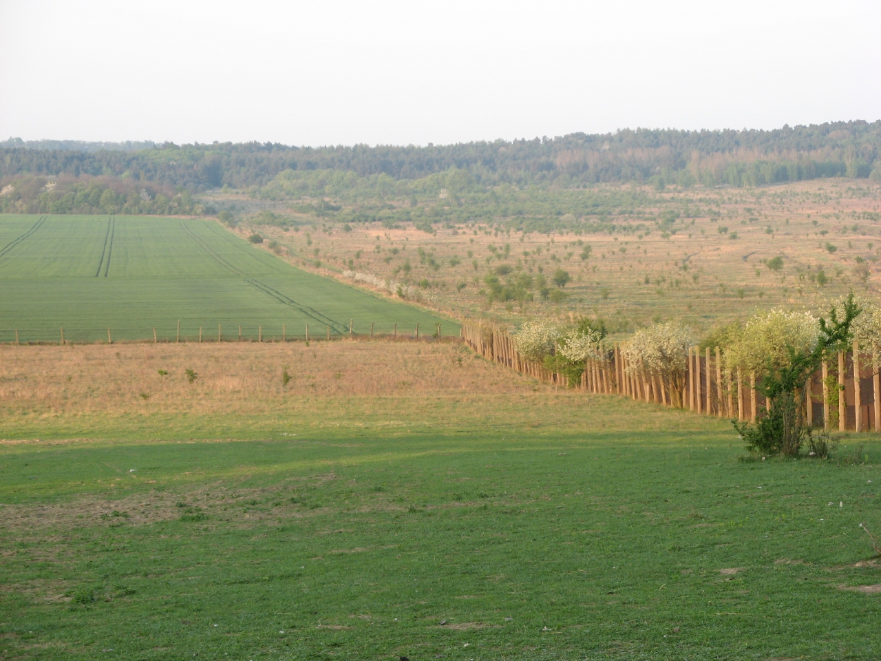
The sites Friedeburg, Greifenhagen, Harsleben, Schafstädt, Siptenfelde and Wanzleben are part of the TERENO Harz / Central German Lowland Observatory in Saxony-Anhalt run by the Helmholtz Centre for Environmental Research UFZ. These sites have a focus on biodiversity monitoring in the “normal landscape” which is characterized by agricultural use (about 60 % coverage of Saxony-Anhalt). Each site is a 4x4 km landscape of mainly arable land and semi-natural habitats like e.g. hedges and forests. The site Harsleben is north of the city of Quedlinburg. A part of it was formerly military training area which was afterwards just grazed by sheep. The site is characterized by a mostly flat topography and has a mean elevation of 143 m asl. The total area covered by crop fields is 67 % and all semi-natural habitats summing up to 17 %.
-
TERENO Harz - central german lowland - Hohes Holz Time series station data includes time series data for the year 2019 for the following parameter: LAI, Eddy Flux, Precipitation, Atmospheric Pressure, Relative Humidity, Air Temperature, Wind Direction, Wind Speed, incoming Long Wave Radiation, outgoing Long Wave Radiation, incoming Short Wave Radiation, outgoing Short Wave Radiation, Photosynthetic Photon Flux Density, Soil Water Content, Soil Temperature, Biomass, Groundwater Level. Please follow the method file for specific and detailed information.
-

The sites Friedeburg, Greifenhagen, Harsleben, Schafstädt, Siptenfelde and Wanzleben are part of the TERENO Harz / Central German Lowland Observatory in Saxony-Anhalt run by the Helmholtz Centre for Environmental Research UFZ. These sites have a focus on biodiversity monitoring in the “normal landscape” which is characterized by agricultural use (about 60 % coverage of Saxony-Anhalt). Each site is a 4x4 km landscape of mainly arable land and semi-natural habitats like e.g. hedges and forests. The site Schafstädt is part of the "Querfurter Platte" ranking about the richest soils in Germany. It is characterized by a quite flat topography and a mean elevation of 177 m asl. The average size of crop fields is highest compared to the other sites and the total area covered by crop fields is still 97 % and all semi-natural habitats summing up to 2 %.
-
The sites Friedeburg, Greifenhagen, Harsleben, Schafstädt, Siptenfelde and Wanzleben are part of the TERENO Harz / Central German Lowland Observatory in Saxony-Anhalt run by the Helmholtz Centre for Environmental Research UFZ. These sites have a focus on biodiversity monitoring in the “normal landscape” which is characterized by agricultural use (about 60 % coverage of Saxony-Anhalt). Each site is a 4x4 km landscape of mainly arable land and semi-natural habitats like e.g. hedges and forests. The site Siptenfelde is in the eastern part of the Harz mountains and characterized by a distinct topography. The mean elevation is 423 m asl and besides meadows and agricultural fields the village Siptenfelde is surrounded by forest. Thus the area covered by forest amounts to 61 %, crop fields 18 % and all semi-natural habitats sum up to 15 %.
-
The sites Friedeburg, Greifenhagen, Harsleben, Schafstädt, Siptenfelde and Wanzleben are part of the TERENO Harz / Central German Lowland Observatory in Saxony-Anhalt run by the Helmholtz Centre for Environmental Research UFZ. These sites have a focus on biodiversity monitoring in the “normal landscape” which is characterized by agricultural use (about 60 % coverage of Saxony-Anhalt). Each site is a 4x4 km landscape of mainly arable land and semi-natural habitats like e.g. hedges and forests. The site Friedeburg is close to the river Saale and about 20 km northwest of the city of Halle (Saale). It is characterized by a distinct topography with valleys and slopes with a mean elevation of 122 m asl. Accordingly the average size of crop fields is lowest compared to the other sites, but the total area covered by crop fields is still 71 % and all semi-natural habitats summing up to 10 %.
-

The sites Friedeburg, Greifenhagen, Harsleben, Schafstädt, Siptenfelde and Wanzleben are part of the TERENO Harz / Central German Lowland Observatory in Saxony-Anhalt run by the Helmholtz Centre for Environmental Research UFZ. These sites have a focus on biodiversity monitoring in the “normal landscape” which is characterized by agricultural use (about 60 % coverage of Saxony-Anhalt). Each site is a 4x4 km landscape of mainly arable land and semi-natural habitats like e.g. hedges and forests. The site Wanzleben is situated in the "Magdeburger Börde", a flat area with highest ranking of soil quailty in Germany.. It is characterized by a mostly flat topography with a mean elevation of 113 m asl. The area covered by crop fields is 77 % and all semi-natural habitats summing up to 8 %.