
US National Science Foundation (NSF)
Type of resources
Available actions
Topics
Keywords
Contact for the resource
Provided by
Years
Formats
Representation types
-
The Kellogg Biological Station (KBS) is located in southwest Michigan in the eastern portion of the U.S. cornbelt, 50 km east of Lake Michigan in the SW corner of the state (42° 24′ N, 85° 24′ W, elevation 288 m). Annual rainfall at KBS averages 1,005 mm/y with about half falling as snow; potential evapotranspiration (PET) exceeds precipitation for about 4 months of the year. Mean annual temperature is 10.1 °C. KBS is 1600 ha of cropping systems, successional communities, and small lakes. Surrounding KBS is a diverse, rural-to-semirural landscape typical of the U.S. Great Lakes and upper Midwest regions. The diversity of land use, soil and vegetation types, and aquatic habitats within a 50-km radius of the Station is high. Most of southwest Michigan is on the pitted outwash plain of the morainic system left by the last retreat of the Wisconsin glaciation, circa 12,000 years ago. Soils in the area developed on glacial till, and include well- and poorly-drained alfisols, mollisols, and entisols. Most regional soils are sandy loam and silty clay loam of moderate fertility, principal Station soils are Typic Hapludalfs. Land use around KBS ranges from urban (Kalamazoo, with a metropolitan population of 180,000, is 20 km south of the Station) to rural; vegetation ranges from cultivated and early successional old fields to older growth oak-hickory and beech-maple forests; and aquatic habitats include more than 200 bodies of water of different morphometries, alkalinities, and degrees of eutrophication within 50 km. Cropping systems in the area are typical of the U.S. cornbelt — mainly corn/soybean rotations with wheat of varying importance, and alfalfa an important forage crop. KBS yields are typical of non-irrigated yields elsewhere in the North Central Region. KBS LTER research is carried out in a variety of experimental systems. The most important of these is the Main Cropping System Experiment (MCSE), which was started in 1989 and consists of 11 different cropping systems or successional plant communities, ranging from annual corn-soybean-wheat rotations to late-successional deciduous forest. All communities are replicated within the landscape.
-
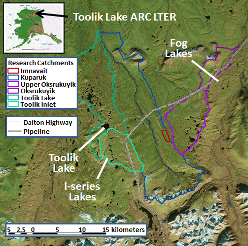
The Arctic LTER research site is in the foothills region of the North Slope of Alaska and includes the entire Toolik Lake watershed and the adjacent watershed of the upper Kuparuk River, down to the confluence of these two watersheds. This area is typical of the northern foothills of the Brooks Range, with continuous permafrost, no trees, a complete snow cover for 7 to 9 months, winter ice cover on lakes, streams, and ocean, and cessation of river flow during the winter. Tussock tundra is the dominant vegetation type but there are extensive areas of drier heath tundra on ridge tops and other well-drained sites as well as areas of river-bottom willow communities. The North Slope is divided into the Coastal Plain (6,000 km2), the Foothills (95,000 km2), and the Mountains (40,000 km2).
-
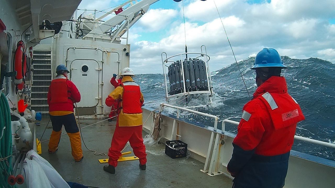
The Northeast US Shelf (NES) ecosystem spans the Middle Atlantic Bight and Gulf of Maine, is a large portion of the NW Atlantic Shelves Province, and is in a coastal biome. The waters over the NES provide an array of ecosystem services including fishing, energy development, shipping, waste disposal, recreation, and conservation. The NES ecosystem, like other productive temperate shelf ecosystems, is characterized by strong seasonality along with high levels of variability in physical forcing at timescales from days to decades, including climate impacts.
-
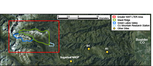
The Niwot Ridge Long Term Ecological Research (LTER) site was established in 1980 with support from the National Science Foundation. The topography, climate and biota of the research site are representative of alpine ecosystems in the southern Rocky Mountains, including extensive expanses of alpine tundra and subalpine coniferous forests, as well as a cirque glacier (Arikaree Glacier), a variety of glacial landforms, lakes and moraines, cirques, talus slopes, patterned ground, and permafrost. The LTER site includes Niwot Ridge, the southern-adjacent Green Lakes Valley, and the University of Colorado’s Mountain Research Station (MRS). Niwot Ridge is part of the Roosevelt National Forest and has been designated a United Nations Educational, Scientific and Cultural Organization (UNESCO) Biosphere Reserve and an Experimental Ecology Reserve (USDA Forest Service). The Green Lakes Valley is a part of the City of Boulder Watershed. The MRS is an interdisciplinary facility devoted to the advancement of the study of mountain ecosystems, providing research and educational opportunities for scientists, students, and the general public.
-
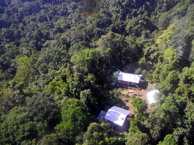
The site comprises 10,000 ha of pristine lowland rainforest in northern Papua New Guinea, owned by indigenous landowners from Wanang Village and declared as Conservation Area. The forest has >500 species of woody plants and largely intact, mildly hunted vertebrate communities. The site includes a field research station (phone, radio, accommodation, catering, solar power) accessible on foot or by helicopter. Further, the site has 50-ha forest dynamics plot from the Center for Tropical Forest Science network, with >300,000 stems tagged and monitored from 2012. There is significant background information on plants, birds, frogs, and several insect taxa. Insect monitoring programme is planned from 2013.
-
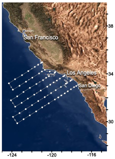
The CCE-LTER site is a coastal upwelling ecosystem. The study region encompasses the southern sector of the California Current System, extending from San Diego northward beyond Monterey Bay and from the shoreline to ~ 500 km offshore. The California Current (CC) proper forms the eastern limb of the large, clockwise circulation of the subtropical gyre of the North Pacific Ocean. As part of the water from the Westwind Drift turns southward and becomes the California Current, it carries cool, fresh water from the Subarctic Pacific. The California Current System off central and southern California includes the broad, eddy-rich southward flowing California Current; a persistent but variable subsurface California Undercurrent centered on the continental slope that carries water of tropical origin poleward; and a circulation over and near the continental shelf that is energetic and highly seasonal, shifting from a wind-driven equatorward flow and coastal upwelling in spring-summer to poleward flow in fall-winter (Hickey 1998). The pelagic ecosystem of the CCE-LTER site is forced by atmospheric and ocean processes on multiple spatial (local, regional, and basin) and temporal (diel through decadal) scales.