
latent heat
Type of resources
Available actions
Topics
Keywords
Contact for the resource
Provided by
Years
Formats
Representation types
-
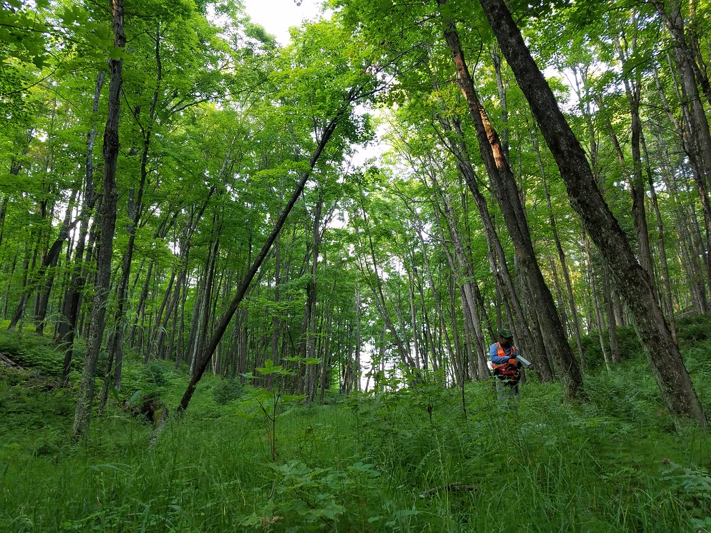
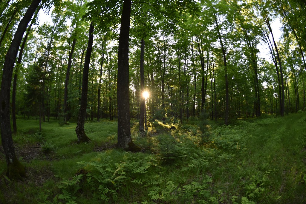
University of Notre Dame Environmental Research Center (UNDERC) is a core terrestrial site in NEON's Great Lakes Domain 5. Straddling the border between Northern Wisconsin and Michigan's Upper Peninsula, the UNDERC property comprises approximately 7500 acres and is maintained as an environmental education and research facility. UNDERC also has 30 lakes comprising 1350 acres, including Crampton Lake, a NEON aquatics site. The flux/meteorological tower at this site is 127ft with 6 measurement levels. The tower top extends above the vegetation canopy to allow sensors mounted at the top and along the tower to capture the full profile of atmospheric conditions from the top of the vegetation canopy to the ground. The tower collects physical and chemical properties of atmosphere-related processes, such as humidity, wind, and net ecosystem gas exchange. Precipitation data are collected by a tipping bucket at the top of the tower, a Double Fence Intercomparison Reference (DFIR) near the tower, and a series of throughfalls located in the soil array. UNDERC site includes airborne remote sensing surveys, automated instrument measurements and observational field sampling.There are also multiple plots for soil sensors and sampling and organismal sampling including birds,mammals, ticks and mosquitoes.
-
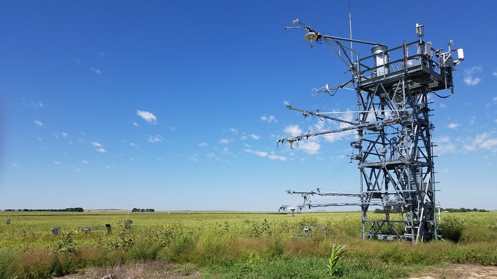
North Sterling (STER) is a relocatable terrestrial site is part of NEON's Central Plains Domain 10. STER is 100 miles to the east of CPER, is hosted by a private landowner with a strong interest in soil science and sustainable agriculture. The family farm has been in operation for nearly 100 years. Currently, the farm supports a mix of cattle grazing and field crops, primarily wheat, millet and hay. Remote sensing surveys of this field site collect lidar, spectrometer and high-resolution RGB camera data. The flux/meteorological tower at this site is 26ft with 4 measurement levels. The tower top extends above the vegetation canopy to allow sensors mounted at the top and along the tower to capture the full profile of atmospheric conditions from the top of the vegetation canopy to the ground. The tower collects physical and chemical properties of atmosphere-related processes, such as humidity, wind, and net ecosystem gas exchange. Precipitation data are collected by a tipping bucket at the top of the tower and a series of throughfalls located in the soil array. This site has five soil plots placed in an array within the airshed of the flux tower. Field ecologists collect the following types of observational data at this site: Terrestrial organisms (birds, ground beetles, mosquitoes, plants, small mammals, soil microbes, ticks), Biogeochemical data, and soil data. Total data products planned for this site: 113
-
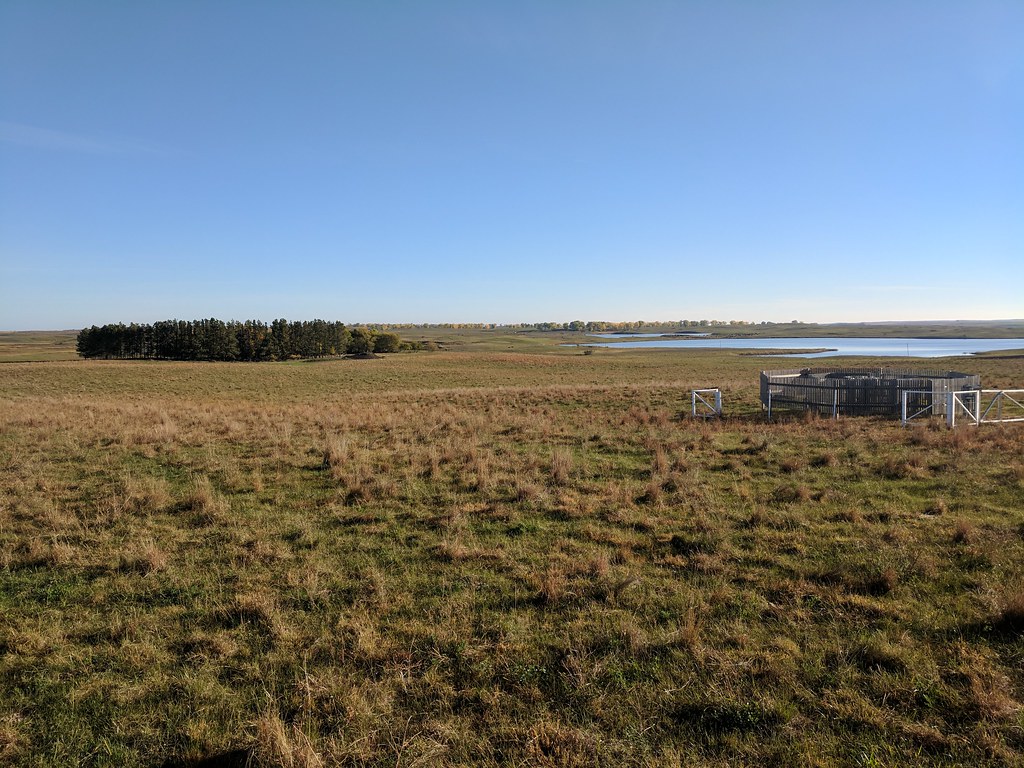
The Woodworth (WOOD) core terrestrial field site is located approximately 100 miles northeast of Bismarck, North Dakota in Stuntsman County. It is encompassed in the Northern Plains Domain, which includes a patchwork of grasslands, agricultural, and wetland/aquatic communities embedded in a matrix of small agrarian communities. This site is a restored praire located in an undulating matrix of small lakes, ponds, and ephemeral praire potholes formed by glaciers 10,000 years ago. It is managed by the U.S. Geological Survey and the U.S. Fish and Wildlife Service, and is part of the larger Chase Lake National Wildlife Refuge (NWR). Remote sensing surveys of this field site collect lidar, spectrometer and high-resolution RGB camera data. The flux/meteorological tower at this site is 26 with 4 measurement levels. The tower top extends above the vegetation canopy to allow sensors mounted at the top and along the tower to capture the full profile of atmospheric conditions from the top of the vegetation canopy to the ground. The tower collects physical and chemical properties of atmosphere-related processes, such as humidity, wind, and net ecosystem gas exchange. Precipitation data are collected by a tipping bucket at the top of the tower and a series of throughfalls located in the soil array. This site has five soil plots placed in an array within the airshed of the flux tower. Field ecologists collect the following types of observational data at this site: Terrestrial organisms (birds, ground beetles, mosquitoes, plants, small mammals, soil microbes, ticks), Biogeochemical data, and soil data.The WOOD terrestrial site produces 110 data products.
-
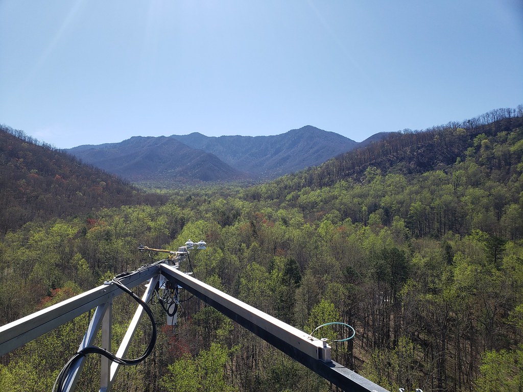
This relocatable terrestrial NEON site, comprised of 13 square miles within the 814 square miles of the Great Smoky Mountains National Park, is characterized by abundant rainfall, variable elevations, and an exceptional richness of biota hosted by closed-canopy deciduous old growth forests. It exists within the NEON Appalachians & Cumberland Plateau Domain, specifically located in the southwest area of Tennessee bordering North Carolina. As one of the largest protected areas in the eastern U.S., it is the most biodiverse park in the National Park system and the most visited. GRSM's terrestrial and aquatic plots are all contained in or near the Gatlinburg Ranger District. These plot locations were chosen because of their subjection to ecological phenomena, logistical convenience, and comparability to D07's core site (which is approximately 70 miles away). Remote sensing surveys of this field site collect lidar, spectrometer and high-resolution RGB camera data. The flux/meteorological tower at this site is 149 with 6 measurement levels. The tower top extends above the vegetation canopy to allow sensors mounted at the top and along the tower to capture the full profile of atmospheric conditions from the top of the vegetation canopy to the ground. The tower collects physical and chemical properties of atmosphere-related processes, such as humidity, wind, and net ecosystem gas exchange. Precipitation data are collected by a tipping bucket at the top of the tower and a series of throughfalls located in the soil array. This site has five soil plots placed in an array within the airshed of the flux tower. Field ecologists collect the following types of observational data at this site: Terrestrial organisms (birds, ground beetles, mosquitoes, plants, small mammals, soil microbes, ticks), Biogeochemical data, and soil data.
-
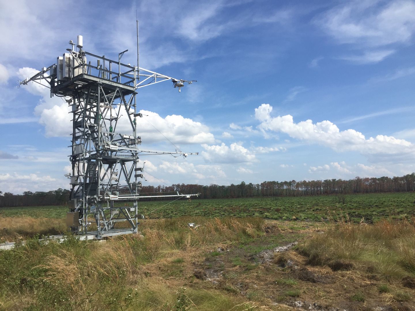
The 12,000-acre Disney Wilderness Preserve straddles the headwaters of the Everglades ecosystem in south-central Florida. This site is seasonally wet and flooded. Remote sensing surveys of this field site collect lidar, spectrometer and high-resolution RGB camera data. The flux/meteorological tower at this site is 26' with 4 measurement levels. This site has five soil plots placed in an array within the airshed of the flux tower.
-
The NEON site at the University of Kansas Field Station (UKFS) is a terrestrial field site located approximately 9 km north of Lawrence, KS, along an eastern deciduous forest and tallgrass prairie transition zone. The UKFS site is one of the two relocatable sites that are encompassed in the NEON Prairie Peninsula Domain, which includes the largest remaining areas of unplowed tallgrass prairie in North America. The Prairie Peninsula domain consists of grasslands, forests, and agricultural cover types. The Domain hosts four other NEON field sites, two aquatic and two terrestrial, all of which are located in Kansas. Remote sensing surveys of this field site collect lidar, spectrometer and high-resolution RGB camera data. The flux/meteorological tower at this site is 126 with 6 measurement levels. The tower top extends above the vegetation canopy to allow sensors mounted at the top and along the tower to capture the full profile of atmospheric conditions from the top of the vegetation canopy to the ground. The tower collects physical and chemical properties of atmosphere-related processes, such as humidity, wind, and net ecosystem gas exchange. Precipitation data are collected by a tipping bucket at the top of the tower and a series of throughfalls located in the soil array. This site has five soil plots placed in an array within the airshed of the flux tower. Field ecologists collect the following types of observational data at this site: Terrestrial organisms (birds, ground beetles, mosquitoes, plants, small mammals, soil microbes, ticks), Biogeochemical data, and soil data.
-
The TALL terrestrial field site covers 5300 hectares within the larger Oakmulgee District of the Talladega National Forest (475,000 hectares) in west-central Alabama. TALL is located within the Gulf Coastal Plain which is the dominant physiographic province (52%) of NEON's Domain 8: Ozarks Complex. It is also where the upper coastal plain gives rise to the Appalachian foothills. The lands of this region are rich a mosaic of forest types and habitats. Steep ridges to rolling hills fading to hardwood bottoms make up the diversity of forest conditions found in Oakmulgee. While known for its longleaf forests, over 40% of Oakmulgee is covered with a mixture of hardwoods and wetlands. Remote sensing surveys of this field site collect lidar, spectrometer and high-resolution RGB camera data. The flux/meteorological tower at this site is 115 with 5 measurement levels. The tower top extends above the vegetation canopy to allow sensors mounted at the top and along the tower to capture the full profile of atmospheric conditions from the top of the vegetation canopy to the ground. The tower collects physical and chemical properties of atmosphere-related processes, such as humidity, wind, and net ecosystem gas exchange. Precipitation data are collected by a tipping bucket at the top of the tower and a series of throughfalls located in the soil array. This site has five soil plots placed in an array within the airshed of the flux tower. Field ecologists collect the following types of observational data at this site: Terrestrial organisms (birds, ground beetles, mosquitoes, plants, small mammals, soil microbes, ticks), Biogeochemical data, and soil data.
-
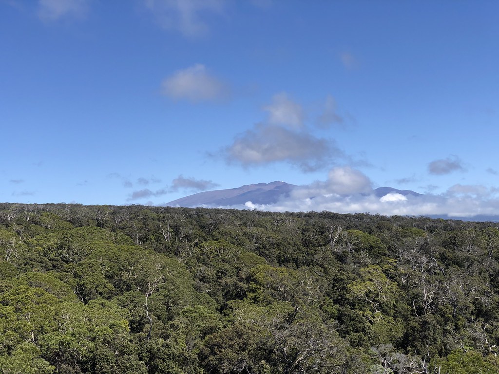
NEON's PUUM field site is located in the Pu'u Maka'ala Natural Area Reserve (NAR) on the eastern side of Hawaii's Big Island, managed by the Hawaii Division of Forestry and Wildlife (DOFAW). More than 18,000 acres in size, the NAR is home to a rainforest with many native species, some of them endangered. It was established to protect some of the Big Island's best wet native forest and unique geologic features. Part of the reserve is fenced to reduce damage from feral ungulates making the area extremely important for the protection of native species. Due to the unique mix of soil conditions, flora and fauna on the island, researchers at PUUM will need to make a number of modifications to the sampling and measurement protocols used at most other NEON field sites. Because the island is volcanic and soil depths average just 4 inches, soil measurement methods have been modified for the site. Field sampling schedules have been modified to minimize traffic through ecologically sensitive areas and accommodate Hawaii's year-round growing season. Small mammal sampling has been eliminated, as Hawaii has only one native terrestrial mammal (the Hawaiian Hoary Bat), an endangered species which is already being monitored by other research programs. Tick sampling has also been eliminated. Tree tagging methods have been modified to avoid creating entry points for ROD in `ohi`a trees. The flux/meteorological tower at this site is 105 with 6 measurement levels. The tower top extends above the vegetation canopy to allow sensors mounted at the top and along the tower to capture the full profile of atmospheric conditions from the top of the vegetation canopy to the ground. The tower collects physical and chemical properties of atmosphere-related processes, such as humidity, wind, and net ecosystem gas exchange. Precipitation data are collected by a Double Fence Intercomparison Reference (DFIR) near the tower, and a series of throughfalls located in the soil array. This site has one phenocam on the top of the flux tower and one near the bottom of the tower. This site has five soil plots placed in an array within the airshed of the flux tower. Biogeochemical data, and soil data is also collected. Total data products planned for this site: 116.
-
Treehaven, situated between Rhinelander and Tomahawk, WI, is one of two relocatable sites located in NEON's Great Lakes Domain 5. The Treehaven property is owned and operated by the University of Wisconsin-Stevens Point (UWSP), College of Natural Resources. UWSP uses the property and conference center for summer field techniques courses but welcomes other educators, researchers, and the public to use and enjoy their forests, trails, and facility. The flux/meteorological tower at this site is 116' with 6 measurement levels. The Treehaven tower location and surrounding tower plots are approximately 1 mile due south of the Steigerwaldt tower and its surrounding plots. Because the sites are managed differently, the close proximity of the towers could help isolate the effect of management practices on carbon cycling dynamics. The tower top extends above the vegetation canopy to allow sensors mounted at the top and along the tower to capture the full profile of atmospheric conditions from the top of the vegetation canopy to the ground. The tower collects physical and chemical properties of atmosphere-related processes, such as humidity, wind, and net ecosystem gas exchange. Precipitation data are collected by a tipping bucket at the top of the tower and a series of throughfalls located in the soil array.site includes airborne remote sensing surveys, automated instrument measurements and observational field sampling.There are also multiple plots for soil sensors and sampling and organismal sampling including birds, ticks, mammals, and mosquitoes. Total data products planned for this site: 112
-
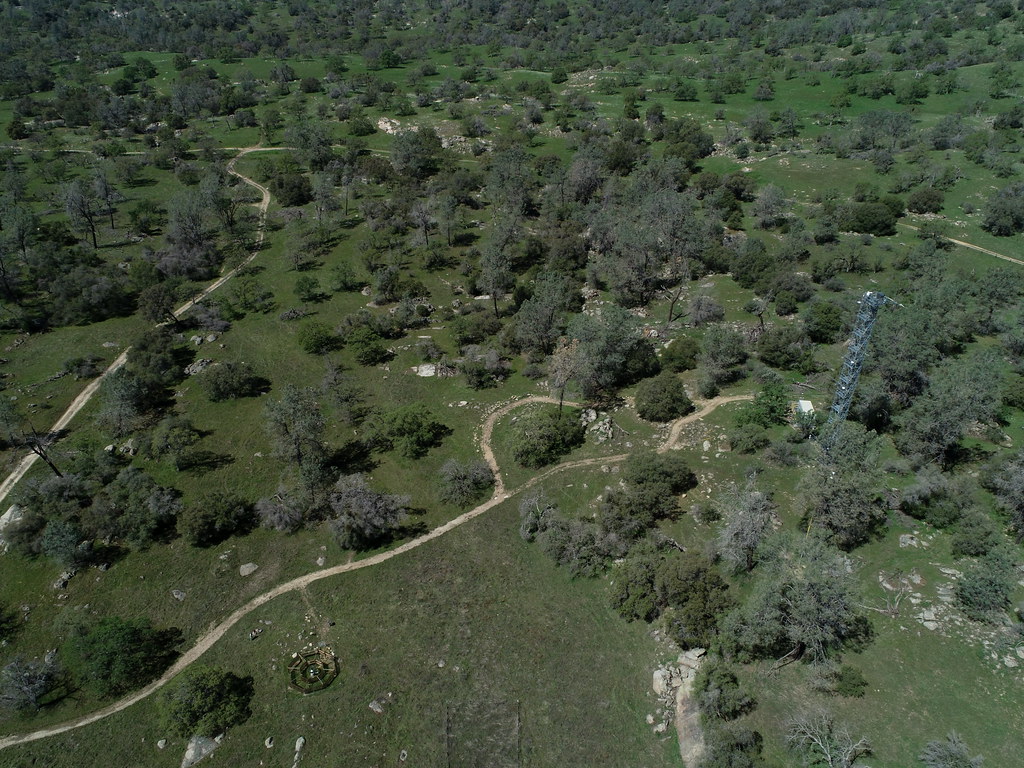
The San Joaquin Experimental range is located approximately 20 miles north of Fresno, CA. The site sits at 210-520 m above sea level, in the foothills of the Sierra Nevada mountains. The area is mainly grassy open oak woodland, and drains into the San Joaquin River basin. SJER is currently managed in collaboration by the Pacific Southwest Research station of the United States Forest Service and California State University at Fresno's Agricultural foundation. It hosts the university's commercial cow-calf herd. The range serves as an outdoor lab for agriculture students at Fresno State and Fresno City College, and is used for extensive ecological and agricultural research. This core site provides: A representative wildland to contrast the design of the relocatable sites, Statistical power for regional-scale understanding, robust design to address expected future changes in climate that are, in turn, expected to influence biodiversity, biogeochemistry, and infectious and invasive species biology. The area immediately surrounding SJER is agricultural, primarily cattle pasture with some wine and fruit production. The site is situated relatively close to two urban areas: the city of Fresno 20 miles south, and Coarsegold/Oakhurst 15 miles north. The site includes a 127' tall flux tower and an underground soil array surrounded by observational sampling plots for plants, animals, soils and microbes.