
ammonium content
Type of resources
Available actions
Topics
Keywords
Contact for the resource
Provided by
Years
Formats
Representation types
-
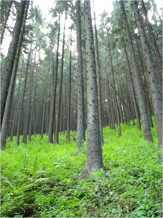
In 1998 a permanent plot (50 x 50 m) was established on the slope of the Nosal Mountain at the height of 970 m asl in 120 year old spruce stand, where in the 120-year-old spruce stand bulk deposition, throughfall and soil solution are collected. The investigations of health status of trees and floral characteristic have been carried out since 2001. The analyses are carried out in a certified laboratory of the Institute for Ecology of Industrial Areas, Katowice (Certificate No AB 325). The basic meteo data are taken from the monitoring station located at Kuźnice (about 1 kn from the plot).
-
UK ECN site. The River Stinchar is situated in South Ayrshire. It rises close to Loch Doon and flows for 46km before entering the Firth of Clyde at Ballantrae. It has a catchment area of 340km2 and its average flow is 11.2 cumecs. The catchment is largely rural with only a few small and scattered communities. Farming is mostly dairy cattle and sheep rearing, and there have been some pollution problems associated with the latter in particular through spillages of sheep dip chemicals. The upper part of the catchment is extensively forested with conifers for commercial use. The granitic geology and the maturity of the trees have resulted in low pH values in the uppermost routine sampling point. Part of the flow of the upper reaches of the river is diverted by an aqueduct to feed water into the Loch Braden water supply reservoir. The ECN site is situated in the lowest reach of the river where the acidity has been buffered by the base cations in the lower part of the catchment.
-
UK ECN site. The River Esk rises on the uplands of the North York Moors National Park and is the only major river in the county of Yorkshire that drains directly into the North Sea. The catchment is sparsely populated without the pressures of industrialisation and urbanisation affecting other rivers in the Region. Open moorland characterises much of the catchment and is an important habitat for a wide variety of wildlife. Within the Esk valley there are six Sites of Special Scientific Interest (SSSIs), two of which extend south and cross the boundary of the Derwent catchment. The source of the Esk is upstream of Westerdale, where a series of small streams (becks) known as the Esklets merge to form the River Esk. Many of these moorland streams are affected by natural "flushes" of acidity, as well as iron run-off from natural ironstone strata and old mineral workings, making some of these becks an ochreous-orange colour after periods of rainfall. The combination of the two factors restrict the invertebrate fauna in these head-streams. The majority of the River Esk downstream of the Esklets has very good water quality, with the diverse invertebrate fauna dominated by mayflies, stoneflies, caddisflies and other pollution sensitive groups. This good water quality is also very important in sustaining other species such as salmon, sea trout, dippers and otters. The ECN site is at Briggswath (NGR: NZ 868 081), approximately 2km upstream of the tidal limit. At this point the river is approximately 15m wide, and in normal summer flows the depths vary between 20cm and 30cm.
-

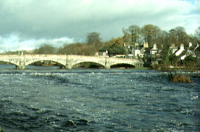
UK ECN site. The catchment area of the River Clyde is about 2000km2 and the river changes in character a great deal in its 121km journey to the tidal weir in Glasgow. In its upper reaches, it is used to fill the Daer reservoir which supplies drinking water to much of South Lanarkshire; there is also sheep farming and commercial afforestation in this part of the catchment. The river is joined by tributaries of various sizes and quality reflecting the land uses of their catchments: there is much opencast coal mining in some, whilst others are urban or agricultural. The Clyde passes through a fertile valley in its middle reaches where there is extensive market gardening, fruit growing and garden centres. In its lower reaches the river receives a considerable amount of treated sewage effluent from large regional sewage works. The river is quite sluggish in its flow because of the flat landscape. As a result of this and the BOD of the effluents, there is serious oxygen depletion in the lower reaches during the summer months. The ECN sampling site is situated in the lowest reach, where average flow is 41 cumecs.
-
UK ECN site. The River Eden drains some 400 km2 of north Fife, 307 sq. kms of which lie upstream of the ECN site at Kemback. The river rises at around 220 m.o.d. and the catchment is predominantly low-lying. The major land use in the area is arable farming and approximately 76% of the catchment is prime agricultural land with very fertile soils or imperfectly drained brown forest and alluvial types. Underlying geology comprises Devonian and Carboniferous strata, the former including the most productive aquifer in Scotland, the Knox Pulpit formation. Water is abstracted from groundwater, the river and its tributaries for irrigating crops. The Balmalcolm area of the catchment is a designated Nitrate Vulnerable Zone under the EEC Nitrate Directive. Although treated sewage is discharged to the river from several small communities and from the town of Cupar, the effect of diffuse inputs from agriculture is believed to be critical to river water quality. There is a modest salmon run to the river and otters are present. The river enters the sea 4 km to the north of St Andrews and its estuary forms the Eden Estuary Local Nature Reserve - an important overwintering site for wildfowl and waders.
-
UK ECN site. The River Cree has a catchment area of 515.7km2, much of which is afforested, and a total river length of 57.5km. It has become one of the most acidic catchments in SW Scotland, with pH values as low as 5.0 being recorded occasionally. The raises concerns about its ability to meet the EC requirements for freshwater fisheries and about the survival of the salmon fishery. There are many sewage effluent discharges entering the river along its course, most of which have small flow rates; the largest discharge is from Newton Stewart. In the early 1980's, large stretches of the river were subject to excessive weed growth, believed to be due to the aerial application of fertilisers over large tracts of forest. The mean pH at Newton Stewart is 6.5, with lower mean pH levels upstream.
-
UK ECN site. The River Eden is a tributary of the River Medway in Kent. It rises south of Caterham and flows eastward through the Wealden clay to join the River Medway near Penshurst. Its main tributaries are the Gibbs Brook, Eden Vale Stream, Eden Brook, and the Felbridge Water. The Eden catchment is largely rural and agricultural although much of the dairy farming which predominated has now declined and has been replaced by mixed farming. The sampling point is east of Penshurst in a flat valley surrounded by agricultural land which is not wooded, and is upsteam of the sluice where the river is slow flowing. There is no industry in the area. Water quality in the Eden is mainly classified as General Quality Assessment (GQA) Class C, although the headwaters near Oxted are Class D. The river receives treated sewage effluent from two Southern Water Services Limited Sewage Treatment Works (STW), serving Edenbridge and Oxted repectively; the stretches receiving these effluents are both subject to EC Urban Water Treatment "Sensitive Waters" investigations. There are other much smaller private sewage treatment works throughout the catchment. The river and its tributaries support coarse fisheries. Average flows at Penshurst range from 3.909 cumecs in January to 0.485 cumecs in July.
-
UK ECN site. The River Bure is one of the major rivers flowing through the Norfolk Broads. The sampling site at Horstead Mill (National Grid Ref. 6267 3198) is in its middle reaches, approximately 40km from the source of the river, at the limit of navigation, and at an elevation of less than10m. Here the river is 17-20m wide and up to 4m deep with a predominantly silty substrate. The surrounding catchment is underlain by Quaternary deposits of Norwich crag with chalk at depth and superficial glacial till and outwash deposits. Land use in the catchment is predominantly agricultural, especially arable. Due to problems with eutrophication of the Broads, there has been a programme of phosphate stripping at the major sewage treatment works on the Bure since 1986. Invertebrate monitoring takes place downstream of the Mill where the river is divided into two channels and there is a riffle area of gravel, pebbles and sand and areas of emergent plants (Sparganium erectum, Glyceria sp.) at the margins. Macrophyte and diatom monitoring takes place between 0.5-1km upstream of the Mill at a semi-natural stretch of river away from man-made structures. The substrate is predominantly silty. There is a diverse submerged plant community, including a good cover of Elodea nuttallii. Several marginal and emergent species are also present.
-
UK ECN site. The River Wye is one of the largest rivers in Britain. It rises on the Plynlimon mountains at 741m AOD and flows through several towns including Rhayader, Builth Wells, Hay-on-Wye and Hereford before meeting the Severn Estuary at Chepstow. The total catchment area is 4136 km2 and the population is centred on the main towns. The River Wye catchment is one of idyllic beauty and unspoilt scenery. The River Wye itself is a Site of Special Scientific Interest (SSSI) and one of the most important rivers in Britain in nature conservation terms. Much of the lower valley is an Area of Outstanding Natural Beauty. The surface water in the Wye and its tributaries is mostly unpolluted, so much of it is suitable as a source of drinking water and for supporting a salmon and trout fishery. Nevertheless, certain rivers and streams in the upper catchment suffer from acidification and localised pollution problems from inadequate sewerage and agricultural sources also exist. The Wye is one of the best known salmon rivers in England and Wales. Shad and Sea Lamprey also migrate into the Wye. The river corridor supports a variety of plant communities, otters, water voles, several bat species, dippers, sandmartins, kingfishers and little ringed plovers. The biological quality of the river is generally good and supports several rare or scarce species including the mayfly Potamanthus luteus , the freshwater pearl mussel Margaritifera margaritifera and the native crayfish. The river also supports several rare species of non-aquatic invertebrates associated with gravel shoals.
-
UK ECN site. The River Ewe, in Wester Ross, is a short stretch of river running north-westwards out of Loch Maree into the sea at Poolewe. The large upland catchment (441.1 km2), which includes Loch Maree and Loch Ewe, is mainly peaty moorland predominantly managed for deer grazing, with some limited hill sheep farming and negligible arable farming. It is well-known for its populations of feral goats. Land rises to over 900m on a number of mountains incuding Slioch and Ben Eighe. Average annual catchment rainfall is 2272mm and long-term average flow at the Poolewe gauging station is 29.64 cumecs. The Ewe catchment is as close to pristine as is possible on the Scottish mainland and, unusually for this part of Scotland, it has no discharges from intensive fish farming. Parts of the catchment are of national scenic and conservation interest and have been designated as a National Nature Reserve (NNR) and National Scenic Area (NSA). There are large areas of deer forest and protected (by SSSI status) woodlands of Scots pine and native oak. There is one small-scale hydro-electric scheme on a tributary flowing into Loch Maree; two further small schemes are proposed. The River Ewe and Loch Maree are important for their salmonid fisheries, but the decline of the trout fishery in Loch Maree is a well recorded phenomenon which is under investigation by the Scottish Office Agriculture, Environment and Fisheries Department (SOAEFD); it is regarded as indicative of such declines generally on the west coast of Scotland.