
environment
Type of resources
Available actions
Topics
Keywords
Contact for the resource
Provided by
Years
Formats
Representation types
Update frequencies
status
Scale
Resolution
-
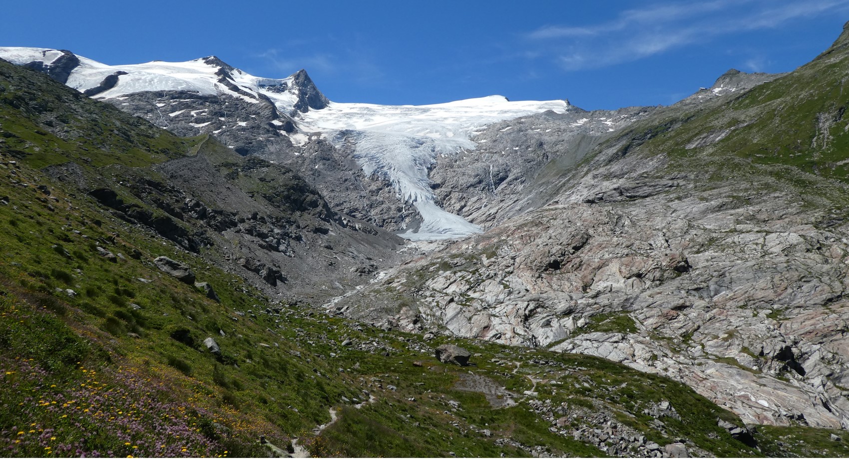
The Hohe Tauern National Park (NPHT) and its region has been conducting specific monitoring programs for research purposes for years, all with links to eLTER. The platform includes a number of measuring facilities, which are all described in specific research sites each, i.e. LTER Hohe Tauern National Park (NPHT), Sonnblick Observatory, Oberes Stubachtal, Mullwitzkees, Venedigerkess and Pasterze. This LTSER platform picks up all possible monitoring acvities within the NPHT region and makes them available for eLTER. The platform is able to carry out and promote natural and social science work.
-
None
-
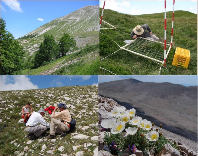
The site consists of orographic islands with high elevation vegetation in central Mediterranean basin, along the Apennines mountain range. It includes 133 plots distributed in the three geographical sectors of Apennines
-
UK ECN site. The River Coln rises at an altitude of about 200m AOD near Sevenhampton in Gloucestershire and flows from the limestone Cotswold Hills in a south-easterly direction to Lechlade where it joins the River Thames at an altitude of about 75m AOD. There are no major tributaries. The sampling site is located in Lechlade about 70m above the confluence with the Thames.The source of the river is in the Inferior Oolite aquifer in which it flows for the first few kilometers, but most of the river runs on the Great Oolite aquifer. Both of the limestone aquifers are sources for water abstration; a total of 55 ml per day are consented from the catchment. The river crosses Oxford Clay before running into the Thames. The catchment is mostly rural, with farming the main industry. The upper catchment is mainly grazing land, and there are large areas of deciduous woodland in the south-west. The upper two-thirds of the catchment is within the Cotswold Area of Outstanding Natural Beauty (AONB), and around Fairford the river has been designated as a Nitrate-sensitive area. There are no large conurbations on the upper catchment, although Cheltenham, from where surface water drains into the limestone above the river's source, has a population of over 100,000. The Coln catchment supports a population of around 9,000. The main sewage inputs to the river are from works at Andoversford, Bibury and Fairford. Bibury Tout farm is the largest discharge into the river, although most of this is 'on-line' through fish-ponds. The river has been subject to various enhancement schemes to improve ecology and fisheries. Water quality was recorded as 'good to fair' in the 1995 General Quality Assessment survey; the classification varies throughout the river, due to the effects of both discharges and low flows. The biological quality of the river is very good. The river supports a brown trout (Salmo trutta) fishery with good spawning beds. Natural populations of grayling (Thymallus thymallus) also exist. Native crayfish (Austropotamobius pallipes) have been recorded but not since 1991; populations of the introduced American signal crayfish (Pacifastacus leniusculus) are also present. Several pollution-sensitive caddisfly and mayfly families have been found, along with true-bugs, beetles and snails.
-
UK ECN site. Lochs Davan and Kinord are situated adjacent to each other in an area of the River Dee catchment known as the Muir of Dinnet. The Muir of Dinnet (area 2287ha) is an SSSI and a Natural Nature Reserve designated because of its value as a habitat for flora and fauna, and important geomorphological features. The Muir forms the south-western corner of the Howe of Cromar, a wide saucer shaped plain at the foot of the Grampian Mountains. The landscape of the area was moulded by gravel and meltwater in the post-glacial era, and Lochs Kinord and Davan are kettleholes (ice depressions), surrounded by fluvio-glacial hummocks, ridges and hollows. Loch Kinord (area 79.0 ha) is oligotrophic whereas Loch Davan (31.1 ha) is mesotrophic with recent research suggesting a transition towards eutrophication. The difference in trophic status reflects the higher proportion of agricultural land use in the Davan catchment.
-
None
-
None
-
None
-
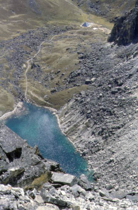
The lake is located in the Khumbu Valley, Sagarmatha National Park (SNP), Nepal. SNP is situated in the Solu-Khumbu district, in the north-eastern region of Nepal and represents the northernmost part of the Dudh Koshi River Basin, which is part of the Koshi River Basin (or SaptaKoshi Basin), one of the seven major hydrographic basins into which Nepal is subdivided. The SNP covers an area of 1141 km2 and is surrounded on all sides by the highest mountain ranges on Earth. The terrain is extremely irregular, with altitudes that reach 8848 m. The lower topographic limit of permanent snow cover is located at an altitude of 5500–5600 m. The climate of the SNP is driven by the Asian monsoon. The lake bedrock is mainly Late Tertiary Granites, with a primarily quartz–silicate composition and a low weathering rate. Soils are absent or very thin in most of the catchments. Vegetation cover is restricted to small areas of alpine meadow. The lake surface area is 0.017 km2. The lake lies above 5000 m a.s.l., the tree line limit. The lake is fed by the outflowing water of an upper lake (lake Piramide Superiore) and indirectly by a small glacier located in the catchment of the upper lake. The lake is ice-covered for ca. 9–10 months every year (from October–November to June–July).Chlorophyll a concentrations are below 1 lg l-1 and are probably controlled by strong grazing pressure from a large pigmented (keto-carotenoid of astaxanthin type) zooplankton community. Total phosphorus concentrations (mean values) are at 3 µg P l-1, whereas total nitrate concentrations are about 100 µg N l-1. Concentrations of particulate organic carbon (POC) and dissolved organic carbon (DOC) are very low.
-
None